
Glossop is a market town in the borough of High Peak, Derbyshire, England, 15 miles (24 km) east of Manchester, 24 miles (39 km) north-west of Sheffield and 32 miles (51 km) north of Matlock. Near Derbyshire's borders with Cheshire, Greater Manchester, South Yorkshire and West Yorkshire, between 150 and 300 metres above sea level, it is bounded by the Peak District National Park to the south, east and north. In 2021, it had a population of 17,825.

Hallamshire is the historical name for an area of South Yorkshire, England, approximating to the current City of Sheffield local government area.

The A57 is a major road in England. It runs east from Liverpool to Lincoln via Warrington, Salford and Manchester, and then through the Pennines over the Snake Pass (between the high moorlands of Bleaklow and Kinder Scout), around the Ladybower Reservoir, through Sheffield and past Worksop. Between Liverpool and Glossop, the road has largely been superseded by the M62, M602 and M67 motorways. Within Manchester a short stretch becomes the Mancunian Way, designated A57(M).

High Bradfield is a rural village 6.5 miles (10 km) north-west of the centre of Sheffield in South Yorkshire, England and within the city's boundaries. The village lies just within the Peak District National Park, 1.3 miles (2 km) inside the park's north-eastern border, is at an altitude of 260 metres (850 feet) AOD, and has extensive views across Bradfield Dale towards Derwent Edge and the Dark Peak.

Low Bradfield is a village within the civil parish of Bradfield in South Yorkshire, England. It is situated within the boundary of the city of Sheffield in the upper part of the Loxley Valley, 6¼ miles west-northwest of the city centre and just inside the northeast boundary of the Peak District National Park. Low Bradfield and the surrounding area is noted for its attractive countryside which draws many visitors from the more urban parts of Sheffield. At weekends the village can become quite crowded, especially when there is a match on the village cricket pitch. Low Bradfield which stands in the shadow of Agden Reservoir has a sister village High Bradfield which is located at a higher altitude, ½ mile to the northeast. The two villages are joined by the steep Woodfall Lane.

Stanage Edge, or simply Stanage is a gritstone escarpment in the Peak District, England, famous as a location for climbing. It lies a couple of miles to the north of Hathersage, and the northern part of the edge forms the border between the High Peak of Derbyshire and Sheffield in South Yorkshire. Its highest point is High Neb at 458 metres (1,503 ft) above sea level. Areas of Stanage were quarried in the past to produce grindstones, and some can still be seen on the hillside—carved, but never removed.

The River Rivelin is a river in Sheffield, South Yorkshire, England.
Malin Bridge is a suburb of the city of Sheffield, England. It is located at grid reference SK325893 and stands 2+1⁄2 miles north-west of the city centre where the rivers Loxley and Rivelin meet. Malin Bridge is only a small district centred on the road bridge over the River Loxley which carries the B6076 road to Stannington ; it is surrounded by the suburbs of Hillsborough, Wisewood, Walkley and Stannington.

Ringinglow is a village in the western section of Sheffield, England. It is on the western border of Ecclesall Ward, and although it is within the boundary of Sheffield, it is self-contained, being entirely surrounded by open countryside. The village now falls within the Fulwood ward of the City.

Fulwood ward—which includes the districts of Fulwood, Lodge Moor, and Ranmoor—is one of the 28 electoral wards in the City of Sheffield, England. It is located in the far western part of the city and covers an area of 23.2 km2. The population of this ward in 2011 was 18,233 people in 6,476 households. Fulwood ward is one of the five wards that make up the Sheffield Hallam Parliamentary constituency. As of June 2022, Andrew Sangar, Sue Alston, and Cliff Woodcraft, all Liberal Democrats, were councillors for the ward. The current Member of Parliament is Labour's Olivia Blake.
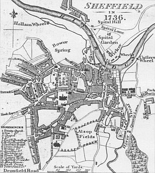
The history of Sheffield, a city in South Yorkshire, England, can be traced back to the founding of a settlement in a clearing beside the River Sheaf in the second half of the 1st millennium AD. The area now known as Sheffield had seen human occupation since at least the last ice age, but significant growth in the settlements that are now incorporated into the city did not occur until the Industrial Revolution.
Sheffield is a geographically diverse city in England. It nestles in the eastern foothills of the Pennines and the confluence of five rivers: Don, Sheaf, Rivelin, Loxley and Porter. As such, much of the city is built on hillsides, with views into the city centre or out to the countryside. The city is roughly one third urban, one third rural and one third in the Peak District. At its lowest point the city stands just 29 metres above sea level at Blackburn Meadows on the Rotherham border, rising up to over 500 m in some parts of the city to a peak of 548m at High Stones on the Derbyshire border; however, 89% of the housing in the city is between 100 and 200 metres above sea level. Over 95% of the population resides in the main urban area.

The Wyming Brook is a river in the City of Sheffield, England. Its source is the Redmires Reservoirs near the Hallam Moors. It flows in a north-easterly direction for over 0.6 miles (1 km) down quite steep terrain into an underground chamber where it joins the Rivelin tunnel before it flows into the lower of the Rivelin Dams. The river flows almost its entire length within the Wyming Brook Nature Reserve, a Site of Special Scientific Interest which is managed by the Wildlife Trust for Sheffield and Rotherham.
The Sheffield Town Trust, formerly officially known as the Burgery of Sheffield, is a charitable trust operating in Sheffield, South Yorkshire, England.

Dungworth is a hamlet in the civil parish of Bradfield, west of Sheffield in South Yorkshire, England.

Rivelin Dams are a pair of water storage reservoirs situated in the upper part of the Rivelin Valley, 5 miles (8 km) west of Sheffield in South Yorkshire, England. The dams are owned by Yorkshire Water and provide water to 319,000 people as well as compensation water for the River Rivelin. They are named Upper and Lower and fall just within the eastern boundary of the Peak District.

The King Edward VII Orthopaedic Hospital was a hospital in the Rivelin Valley area of Sheffield, England. The hospital closed in 1992 and the building has been converted into residential apartments.

Rivelin Valley Park is a public recreation area in the Rivelin Valley area of Sheffield, England. The facilities consist of a playground and a small water park as well as a café. The park is situated on the Rivelin Valley Nature Trail, which is maintained by volunteers from the Rivelin Valley Conservation Group.

Storrs is a hamlet within the boundaries of the City of Sheffield in England, 4 miles (6.4 km) west-northwest of the city centre. It is between the suburb of Stannington and the village of Dungworth in the civil parish of Bradfield at a height of 210 metres above sea level between the Loxley and Rivelin valleys. Although historically a farming settlement, water-powered milling on the Storrs Brook and small-scale cutlery making has also taken place in the hamlet.
Fulwood is a residential suburb and ward of the City of Sheffield in England, it lies 5.5 km west-southwest of the city centre. Formerly an ancient settlement and village on the Porter Brook, it became integrated into the city in the 1930s. It is bounded by the suburbs of Lodge Moor to the NW, Ranmoor to the east and Crosspool to the NE. The open countryside of the Peak District lies to the west and SW. The sub districts of Stumperlowe and Goole Green are part of the suburb. The population of the ward at the 2011 Census was 18,233. Fulwood is located in the Sheffield Hallam constituency which, as of the 2019 general election voted Labour.


