Hillsborough is an electoral ward which includes the districts of Malin Bridge, Owlerton, Wadsley and Wisewood. It is one of the 28 electoral wards in City of Sheffield, England. It is located in the northwestern part of the city and covers an area of 4.6 km2. The population of this ward in 2011 was 18,605 people in 8,012 households.

Park Hill is a housing estate in Sheffield, South Yorkshire, England. It was built between 1957 and 1961, and in 1998 was given Grade II* listed building status. Following a period of decline, the estate is being renovated by developers Urban Splash into a mostly private mixed-tenure estate made up of homes for market rent, private sale, shared ownership, and student housing while around a quarter of the units in the development will be social housing. The renovation was shortlisted for both the 2013 and 2024 RIBA Stirling Prize, for the first and second phases of the redevelopment respectively. The Estate falls within the Manor Castle ward of the City. Park Hill is also the name of the area in which the flats are sited. The name relates to the deer park attached to Sheffield Manor Lodge, the remnant of which is now known as Norfolk Park.

Ecclesall Ward—which includes the neighbourhoods of Banner Cross, Bents Green, Carterknowle, Ecclesall, Greystones, Millhouses, and Ringinglow—is one of the 28 electoral wards in the Sheffield district, in the county of South Yorkshire, England. It is located in the southwestern part of the city and covers an area of 3.6 square miles. The population of this ward in 2007 was 19,211 people in 7,626 households, reducing to 6,657 at the 2011 Census. Ecclesall ward is one of the four wards that make up the South West Community Assembly and one of five wards that make up the Sheffield Hallam Parliamentary constituency. The Member of Parliament is Olivia Blake, a Labour MP. Ecclesall is one of the least socially deprived wards in the entire country, with a 2002 deprivation score of 4.7—making it the 8,105th most deprived ward out of 8,414 wards in the country. The demographic consists largely of white, middle-class families.

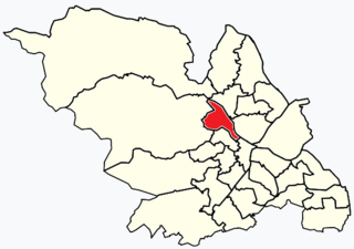
Broomhill and Sharrow Vale — which includes the districts of Broomhill, Broomhall, Crookesmoor, Endcliffe, Sharrow Vale and Tapton Hill — is one of the 28 electoral wards in City of Sheffield, England. The ward was created following the 2015 local government boundary review out of parts of the old Broomhill, Central and Nether Edge wards. It is located in the western part of the city. The population of the Broomhill ward in 2011 was 16,966 people in 5,708 households, covering an area of 2.7 km2. Broomhill & Sharrow Vale is one of the wards that make up the Sheffield Central Parliamentary Constituency.

Walkley is an electoral ward in Sheffield, South Yorkshire, England.

Beighton —which includes the districts of Beighton, Hackenthorpe, Owlthorpe, and Sothall—is one of the 28 electoral wards in City of Sheffield, England. It is located in the eastern part of the city, on the border with Rotherham and covers an area of 5.7 km2. The population of this ward in 2011 was 17,939 people in 7,538 households.

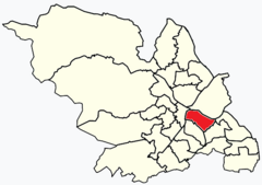
Park & Arbourthorne ward—which includes the districts of Arbourthorne, Gleadless, and Norfolk Park—is one of the 28 electoral wards in City of Sheffield, England. It is located in the southeastern part of the city and covers an area of 1.74 square miles (4.5 km2). The population of this ward in 2001 was 17,500 people in 7,800 households. The ward population at the 2011 Census was 19,133. It is one of the five wards that form the Sheffield Heeley parliamentary constituency.

Southey ward—which includes the districts of Fox Hill, New Parson Cross, Southey, Wadsley Bridge, and part of Old Parson Cross—is one of the 28 electoral wards in City of Sheffield, England. It is located in the northern part of the city and covers an area of 1.8 square miles. The population of this ward in 2011 was 19,086 people in 8,295 households. It is one of the wards that make up the Sheffield Brightside and Hillsborough constituency.
Meersbrook is a suburban district in the south-west of Sheffield, England bordered by Nether Edge to the west, Norton Lees to the south, Heeley to the north and the Meersbrook allotment site to the east. Until 1950 it was part of the Sheffield Ecclesall constituency and now forms part of the Sheffield Heeley constituency. The district falls within the Gleadless Valley ward of the city. The name comes from the stream, the Meers Brook, a tributary of the River Sheaf which means 'boundary brook' and in ancient times this, along with the River Sheaf was thought to have formed the boundary between the kingdoms of Northumbria and Mercia. It remained as the boundary between Yorkshire and Derbyshire into the 20th century. Meersbrook itself was once several small communities which have given many roads their names; Rush Dale, Carfield & Cliffe Field and in 1857 was known as Mears Brook.
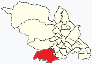
Beauchief and Greenhill ward—which includes the districts of Batemoor, Beauchief, Chancet Wood, Greenhill, Jordanthorpe, Lowedges and Meadowhead—is one of the 28 electoral wards in the City of Sheffield, England. It is in the southern part of the city and covers an area of 2.4 square miles (6.2 km2). The population of the ward in 2016 was estimated to be 19,669 people in 9,209 houses.

Richmond is a suburb of Sheffield in South Yorkshire, England. It lies in the eastern part of the city.

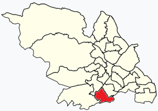
Gleadless Valley ward—which includes the districts of Gleadless Valley, Heeley, Lowfield, and Meersbrook—is one of the 28 electoral wards in City of Sheffield, England. It is located in the southern part of the city and covers an area of 4.5 km2. The population of this ward in 2011 was 21,089 people in 9,516 households. It is one of the five wards that form the Sheffield Heeley parliamentary constituency in the House of Commons. Gleadless Valley actually describes the valley that separates Hemsworth from Herdings, and is a broad area that covers several housing estates: Hemsworth, Herdings and Rollestone. Gleadless Valley is bordered by Gleadless and Norton.
Dore and Totley ward—which includes the districts of Bradway , Dore, Totley, and Whirlow—is one of the 28 electoral wards in City of Sheffield, England. It is currently represented by three Liberal Democrat councillors. It is located in the southwestern part of the city and covers an area of 26.3 km2. The population of this ward in 2001 was 16,404 people in 7,037 households. Dore and Totley ward is one of the five wards that make up the Sheffield Hallam Parliamentary constituency. The population of Dore and Totley is 16,740 (2011) with 7,334 Households.

Fulwood ward—which includes the districts of Fulwood, Lodge Moor, and Ranmoor—is one of the 28 electoral wards in the City of Sheffield, England. It is located in the far western part of the city and covers an area of 23.2 km2. The population of this ward in 2011 was 18,233 people in 6,476 households. Fulwood ward is one of the five wards that make up the Sheffield Hallam Parliamentary constituency. As of June 2022, Andrew Sangar, Sue Alston, and Cliff Woodcraft, all Liberal Democrats, were councillors for the ward. The current Member of Parliament is Labour's Olivia Blake.

Birley ward — which includes the area of Frecheville, and parts of Gleadless and Hackenthorpe — is one of the 28 electoral wards in City of Sheffield, England. It is located in the southeastern part of the city and covers an area of 5.1 square kilometres (2 sq mi). The population of this ward in 2011 was 16,943 people in 7,393 households. It is one of the five wards that make up the Sheffield South East constituency.

Burngreave ward—which includes the districts of Burngreave, Fir Vale, Grimesthorpe, Pitsmoor, and Shirecliffe—is one of the 28 electoral wards in City of Sheffield, England. It is located in the northern part of the city and covers an area of 2.8 square miles. The population of this ward in 2011 was 27,481 people in 9,906 households. It is one of the wards that make up the Sheffield, Brightside and Hillsborough constituency. Most of the ward is served by a free community newspaper, the Burngreave Messenger.

Mosborough is an electoral ward of the City of Sheffield, England, in the eastern part of the city, on the border with North East Derbyshire District. The population in 2011 was 17,097. It is one of the wards that make up the Sheffield South East constituency.

Firth Park ward—which includes the districts of Firth Park, Longley, Parson Cross and parts of Wincobank—is one of the 28 electoral wards in City of Sheffield, England located in the northern part of the city and covering an area of 1.66 square miles (4.3 km2). The population of this ward in 2011 was 21,141 people in 8,602 households.
Middlewood is a north western suburb of Sheffield, South Yorkshire, England. The suburb falls within the Stannington ward of the City.
Fulwood is a residential suburb and ward of the City of Sheffield in England, it lies 5.5 km west-southwest of the city centre. Formerly an ancient settlement and village on the Porter Brook, it became integrated into the city in the 1930s. It is bounded by the suburbs of Lodge Moor to the NW, Ranmoor to the east and Crosspool to the NE. The open countryside of the Peak District lies to the west and SW. The sub districts of Stumperlowe and Goole Green are part of the suburb. The population of the ward at the 2011 Census was 18,233. Fulwood is located in the Sheffield Hallam constituency which, as of the 2019 general election voted Labour.