
Beckenham is a town in Greater London, England, within the London Borough of Bromley. Prior to 1965, it was part of Kent. It is situated north of Elmers End and Eden Park, east of Penge, south of Lower Sydenham and Bellingham, and west of Bromley and Shortlands, and 8.4 miles (13.5 km) south-east of Charing Cross. Its population at the 2011 Census was 46,844.

Catford is a district in south east London, England, and the administrative centre of the London Borough of Lewisham. It is southwest of Lewisham itself, mostly in the Rushey Green and Catford South wards. The population of Catford, including Bellingham, was 44,905 in 2011.

Chislehurst is a suburban district of south-east London, England, in the London Borough of Bromley. It lies east of Bromley, south-west of Sidcup and north-west of Orpington, 10 miles (16 km) south-east of Charing Cross. Before the creation of Greater London in 1965, it was in Kent. According to the 2021 census, Chislehurst has a population of 15,600.

Crofton Park is a mainly residential suburb and electoral ward in the London Borough of Lewisham.

Sydenham is a district of south-east London, England, which is shared between the London boroughs of Lewisham, Bromley and Southwark. Prior to the creation of the County of London in 1889, Sydenham was located in Kent, bordering Surrey. Historically, the area was very affluent, with the Crystal Palace being relocated to Sydenham Hill in 1854. Today, Sydenham is a diverse area, with a population of 28,378 and borders Forest Hill, Dulwich, Crystal Palace, Penge, Beckenham, Catford and Bellingham.

Lewisham is a London borough in south-east London, England. It forms part of Inner London. The principal settlement of the borough is Lewisham. The local authority is Lewisham London Borough Council, based in Catford. The Prime Meridian passes through Lewisham. Blackheath, Goldsmiths, University of London and Millwall F.C. are located within the borough.

Lewisham is an area of southeast London, England, six miles south of Charing Cross. It is the principal area of the London Borough of Lewisham, and was within the historic county of Kent until 1889. It is identified in the London Plan as one of 35 major centres in Greater London, with a large shopping centre and street market. Lewisham had a population of 60,573 in 2011.

The Metropolitan Borough of Lewisham was a metropolitan borough in the County of London between 1900 and 1965, when it became part of the London Borough of Lewisham along with the Metropolitan Borough of Deptford.

Downham is a district of South East London, England, primarily within the London Borough of Lewisham and some parts in the London Borough of Bromley. It is located north of Bromley and south of Catford.
New Eltham is a suburban area of South East London, England, primarily in the Royal Borough of Greenwich with some parts in the London Borough of Bexley. It is located south east of Eltham and north west of Sidcup.

Lewisham West was a borough constituency in south-east London represented in the House of Commons of the Parliament of the United Kingdom. It elected one Member of Parliament (MP) by the first past the post system of election from 1918, until it was abolished for the 2010 general election.

Lewisham parks and open spaces are part of the "green lung" of London and include a diverse range of sites, from small urban parks and gardens to one of the most historic natural landscapes in Greater London at Blackheath. While overall control rests with London Borough of Lewisham, management of borough-owned parks and their facilities is contracted out to Glendale Grounds Management.

Lewisham West and Penge was a constituency in Greater London created in 2010 and represented in the House of Commons of the UK Parliament.

Sydenham Hill forms part of a longer ridge and is an affluent locality in southeast London. It is also the name of a road which runs along the northeastern part of the ridge, demarcating the London Boroughs of Southwark, Bromley, and Lewisham. Its highest part is the apex of the Boroughs of Southwark and Lewisham and the 15th-highest peak in London, at 367 feet (112 m).

Horn Park is an area of south east London south west of Eltham. It is located 12.5 km (7.8 mi) southeast of Charing Cross on the southwest edge of the Royal Borough of Greenwich and borders both the London Borough of Lewisham and the London Borough of Bromley. There is a public park also named Horn Park and two schools in the area. The River Quaggy flows northward though Horn Park, and the suburb is covered by the postcode district SE12, which was previously called the Lee postal district. There is community centre located in Horn Park Estate on Sibthorpe Road, that hosts a number of activities, such as Christian, council and MP meetings, and numerous classes including dance, karate and English.
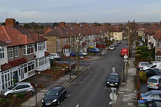
Whitefoot was until 2022 an electoral ward in the London Borough of Lewisham. Its area is 13 km (8.1 mi) south-east of Charing Cross, and north of Downham, south of Catford, west of Grove Park, and east of Bellingham. The ward was named after Whitefoot Lane, which formed much of its northern boundary.

The Mid-Kent line is a British railway line running from Courthill Loop North junction to Hayes railway station in the London Borough of Bromley. Despite its name, none of the line is in the present-day county of Kent.

Southend is a small residential locality in the London Borough of Lewisham in southeast London, England. It was historically a rural village at the south of the parish of Lewisham, Kent that remained undeveloped until after the First World War. It is now a residential suburb, with some large retail stores, within the built-up area of London.

Forster Memorial Park, is a public park in London Borough of Lewisham. It takes up the land between Bellingham Road and Whitefoot Lane, Catford – the park and surrounding roads form Southend or Southend Village. The nearest stations are Bellingham and Beckenham Hill.
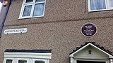 Plaque showing former home of heavyweight boxing champion Henry Cooper at 120 Farmstead Road, Bellingham, London Borough of Lewisham
 Adolf Street in the Bellingham Estate which was constructed during Adolf Hitler's rise to power as leader of the German Nationalist Socialist Party


