
Bloomsbury is a district in the West End of London, part of the London Borough of Camden in England. It is considered a fashionable residential area, and is the location of numerous cultural, intellectual, and educational institutions. Bloomsbury is home of the British Museum, the largest museum in the United Kingdom, and several educational institutions, including University College London and a number of other colleges and institutes of the University of London as well as its central headquarters, the New College of the Humanities, the University of Law, the Royal Academy of Dramatic Art, the British Medical Association and many others. Bloomsbury is an intellectual and literary hub for London, as home of world-known Bloomsbury Publishing, publishers of the Harry Potter series, and namesake of the Bloomsbury Group, a group of British intellectuals which included author Virginia Woolf, biographer Lytton Strachey, and economist John Maynard Keynes.

Clerkenwell is an area of central London, England.

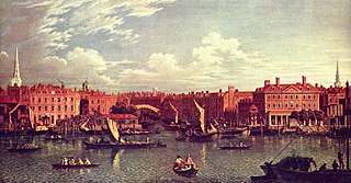
Holborn, an area in central London, covers the south-eastern part of the London Borough of Camden and a part of the Ward of Farringdon Without in the City of London.
The River Fleet is the largest of London's subterranean rivers, all of which today contain foul water for treatment. It has been used as a culverted sewer since the development of Joseph Bazalgette's London sewer system in the mid-19th century with the water being treated at Beckton Sewage Treatment Works. Its headwaters are two streams on Hampstead Heath, each of which was dammed into a series of ponds—the Hampstead Ponds and the Highgate Ponds—in the 18th century. At the southern edge of Hampstead Heath these descend underground as sewers and join in Camden Town. The waters flow 4 miles (6 km) from the ponds.

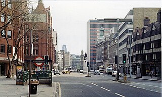
Hatton Garden is a street and commercial zone in the Holborn district of the London Borough of Camden, abutting the narrow precinct of Saffron Hill which then abuts the City of London. It takes its name from Sir Christopher Hatton, a favourite of Queen Elizabeth I, who established a mansion here and gained possession of the garden and orchard of Ely Place, the London seat of the Bishops of Ely. It remained in the Hatton family and was built up as a stylish residential development in the reign of King Charles II. For some decades it often went, outside of the main street, by an alternative name St Alban's Holborn, after the local church built in 1861.
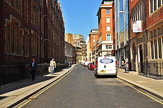
High Holborn is a street in Holborn and Farringdon Without, Central London, which forms a part of the A40 route from London to Fishguard. It starts in the west at the eastern end of St Giles High Street and runs past the Kingsway and Southampton Row, becoming Holborn at its eastern junction with Gray's Inn Road. The western stretch, as far as Drury Lane, was formerly known as Broad Street. On High Holborn, traffic flows one-way westbound from its junction with Drake Street to its western end, and flows both ways for the remainder.
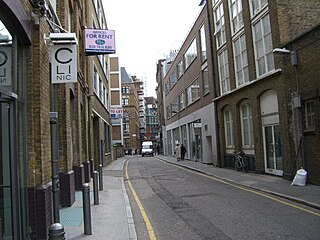
Saffron Hill is a street and former ward in Holborn, in the south eastern corner of the London Borough of Camden, between Farringdon Road and Hatton Garden. The name of the street derives from the fact that it was at one time part of an estate on which saffron grew. The ecclesiastical parish was St Peter, Saffron Hill, a daughter parish of Holborn, which is now combined with St Alban, Holborn.

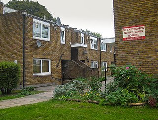
The Holly Lodge Estate is a housing estate in Highgate, north London.

Robin Hood Gardens is a residential estate in Poplar, London, designed in the late 1960s by architects Alison and Peter Smithson and completed in 1972. It was built as a council housing estate with homes spread across 'streets in the sky': social housing characterised by broad aerial walkways in long concrete blocks, much like the Park Hill estate in Sheffield; it was informed by, and a reaction against, Le Corbusier's Unité d'Habitation. The estate was built by the Greater London Council, but subsequently the London Borough of Tower Hamlets became the landlord.
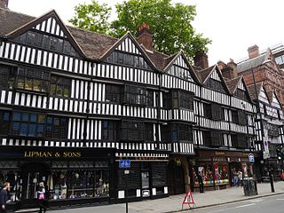
Staple Inn is a part-Tudor building on the south side of High Holborn street in the City of London, London, England. Located near Chancery Lane tube station, it is used as the London venue for meetings of the Institute and Faculty of Actuaries, and is the last surviving Inn of Chancery. It was designated a Grade I listed building in 1974.

Grahame Park, located on the site of the old Hendon Aerodrome in North West London, is a north London housing estate in the London Borough of Barnet, including 1,777 council homes built in the 1970s.

Gray's Inn Road is an important road in Central London, located in the London Borough of Camden. The road begins at its junction with Holborn at the City of London boundary, passes north through the Holborn and King's Cross districts and terminates at King's Cross railway station. It is designated as part of the A5200 road.
Chancery Lane is a one-way street that forms part of the western boundary of the City of London. The east side of the street is entirely within the City, whilst the west side is in the City of Westminster south of Carey Street and the London Borough of Camden north of that street. The route originated as a 'new lane' created by the Knights Templar from their original 'old Temple' on the site of the present Southampton Buildings on Holborn, in order to access to their newly acquired property to the south of Fleet Street sometime before 1161.

Regent's Park Estate is a large housing estate in the London Borough of Camden. The estate consists of nearly 2,000 homes across 49 buildings and lies on either side of Robert Street, between Albany Street and Hampstead Road. It is immediately to the east of the Regent's Park estate owned by the Crown Estate. The estate includes the sites of Cumberland Market, Munster Square and Clarence Gardens.

The London Borough of Camden is a London borough in Inner London, England. Camden Town Hall, on Euston Road, lies 1.4 mi (2.3 km) north of Charing Cross. The borough was established on 1 April 1965 from the former metropolitan boroughs of Holborn, St Pancras and Hampstead.

Charles Fitzroy Doll JP, FRIBA (1850–1929), was an English architect of the Victorian and Edwardian eras who specialised in designing hotels. He also designed the dining room on the RMS Titanic, which was based on his design for that in the Hotel Russell in Bloomsbury.

The Ossulston Estate is a multi-storey council estate built by the London County Council on Chalton Street in Somers Town between 1927 and 1931. It was unusual at the time both in its inner-city location and in its modernist design, and all the original parts of the estate are now Grade II listed buildings.
In London, the Metropolitan Association for Improving the Dwellings of the Industrious Classes (MAIDIC) was a Victorian-era, philanthropically-motivated model dwellings company. The association, established in 1841, was fore-runner of the modern housing association which sought to provide affordable housing for the working classes on a privately run basis, with a financial return for investors. Although not the first society to build such homes, the Association was the first to be founded expressly for this purpose. As such it was one of the earliest adopters of the principal of the five per cent philanthropy model, outlined in the Company's resolution: "that an association be formed for the purpose of providing the labouring man with an increase of the comforts and conveniences of life, with full return to the capitalist."

Central Saint Giles is a mixed-use development in central London. Built at a cost of £450 million and completed in May 2010, it was designed by the Italian architect Renzo Piano and is his first work in the UK. The development consists of two buildings of up to 15 storeys in height, arranged around a public courtyard lined with shops and restaurants. It is chiefly notable for its façades, covered with 134,000 glazed tiles in vivid shades: orange, red, lime green and a warm yellow. It has attracted a number of high-profile tenants including NBCUniversal, MindShare, and Google.
Cressingham Gardens is a council garden estate in Lambeth. It is located on the southern edge of Brockwell Park. It comprises 306 dwellings, a mixture of four, three and two-bedroom houses, and one-bedroom apartments. It was designed at the end of the 1960s by the Lambeth Borough Council Architect Edward Hollamby and second architect Roger Westman, and built at the start of the 1970s. In 2012 Lambeth Council proposed demolishing the estate, to replace the terraced houses by apartment blocks. Most of the apartments would then be for sale to the private sector. The residents, those in Lambeth who wish to prevent the gentrification of the borough, and those who want to conserve what they believe to be important architectural heritage, are campaigning to prevent its demolition.
