
Holborn, an area in central London, covers the south-eastern part of the London Borough of Camden and a part of the Ward of Farringdon Without in the City of London.

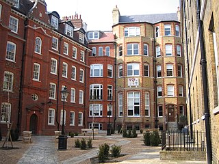
The Honourable Society of the Middle Temple, commonly known simply as Middle Temple, is one of the four Inns of Court entitled to call their members to the English Bar as barristers, the others being the Inner Temple, Gray's Inn and Lincoln's Inn. It is located in the wider Temple area of London, near the Royal Courts of Justice, and within the City of London. As a liberty, it functions largely as an independent local government authority.

The Honourable Society of Lincoln's Inn is one of the four Inns of Court in London to which barristers of England and Wales belong and where they are called to the Bar.
The Honourable Society of the Inner Temple, commonly known as the Inner Temple, is one of the four Inns of Court and is a professional association for barristers and judges. To be called to the Bar and practise as a barrister in England and Wales, a person must belong to one of these Inns. It is located in the wider Temple area, near the Royal Courts of Justice, and within the City of London. As a liberty, it functions largely as an independent local government authority.

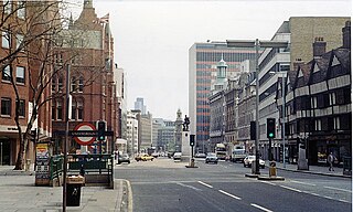
Fleet Street is a street in Central London, England. It runs west to east from Temple Bar at the boundary of the Cities of London and Westminster to Ludgate Circus at the site of the London Wall and the River Fleet from which the street was named.
Farringdon is an area in London and is located in the London Borough of Islington. It lies just north of the border with the City of London in Central London and close to Holborn. The term is used to describe the area around Farringdon station.
High Holborn is a street in Holborn and Farringdon Without, Central London, which forms a part of the A40 route from London to Fishguard. It starts in the west at the eastern end of St Giles High Street and runs past the Kingsway and Southampton Row, becoming Holborn at its eastern junction with Gray's Inn Road. The western stretch, as far as Drury Lane, was formerly known as Broad Street. On High Holborn, traffic flows one-way westbound from its junction with Drake Street to its western end, and flows both ways for the remainder.

Holborn Viaduct is a road bridge in London and the name of the street which crosses it. It links Holborn, via Holborn Circus, with Newgate Street, in the City of London, England financial district, passing over Farringdon Street and the subterranean River Fleet. The viaduct spans the steep-sided Holborn Hill and the River Fleet valley at a length of 1,400 feet (430 m) and 80 feet (24 m) wide. City surveyor William Haywood was the architect and the engineer was Rowland Mason Ordish.

The Temple is an area of the City of London surrounding Temple Church. It is one of the main legal districts in London and a notable centre for English law, since the middle ages to the present day. It consists of the Inner Temple and the Middle Temple, which are two of the four Inns of Court and act as local authorities in place of the City of London Corporation as to almost all structures and functions. Before the establishment of these Inns of Court, the Temple area was the precinct given to the Knights Templar until they were suppressed in 1312, but the area has retained the name from that time. It became a centre of the legal profession soon thereafter.
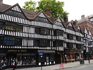
Staple Inn is a part-Tudor building on the south side of High Holborn street in the City of London, London, England. Located near Chancery Lane tube station, it is used as the London venue for meetings of the Institute and Faculty of Actuaries, and is the last surviving Inn of Chancery. It was designated a Grade I listed building in 1974.

Farringdon Without is the most westerly ward of the City of London, England. Its suffix Without reflects its origin as lying beyond the City's former defensive walls. It was first established in 1394 to administer the suburbs west of Ludgate and Newgate, including West Smithfield and Temple. This was achieved by splitting the very large, pre-existing Farringdon Ward into two parts, Farringdon Within and Farringdon Without. The large and prosperous extramural suburb of Farringdon Without has been described as having been London's first West End.

The Liberty of the Rolls was a liberty, and civil parish, in the metropolitan area of London, England.

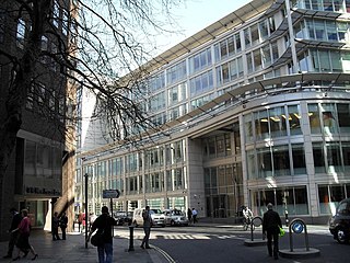
The Maughan Library is the main university research library of King's College London, forming part of the Strand Campus. A 19th-century neo-Gothic building located on Chancery Lane in the City of London, it was formerly the home to the headquarters of the Public Record Office, known as the "strong-box of the Empire", and was acquired by the university in 2001. Following a £35m renovation designed by Gaunt Francis Architects, the Maughan is the largest new university library in the United Kingdom since World War II.
Fetter Lane is a street in the ward of Farringdon Without in the City of London, England. It forms part of the A4 road and runs between Fleet Street at its southern end and Holborn.
Thavie's Inn was a former Inn of Chancery, associated with Lincoln's Inn, established at Holborn, near the site of the present side street and office block still known as Thavies Inn Buildings. Thavie's Inn is one of the earliest Inns of Chancery on record, both by date of establishment and dissolution. It remains a well-known City of London landmark, where Lloyd's Bank is situated, on the opposite side of Holborn Circus from Ely Place.

Holborn and Covent Garden is a ward of the London borough of Camden, in the United Kingdom. As the name suggests, it covers the parts of Holborn and Covent Garden that lie in Camden; the eastern part of Holborn lies in the City of London and the southern part of Covent Garden lies in the City of Westminster. For elections to Parliament, Holborn and Covent Garden is part of Holborn and St Pancras.

Stone Buildings, Lincoln's Inn were constructed from 1774 to 1780. The architect was Sir Robert Taylor. Stone Buildings is a Grade I listed building. Stone Buildings appear in Anthony Trollope's novel The Prime Minister.

The dragon boundary marks are cast iron statues of dragons on metal or stone plinths that mark the boundaries of the City of London. The dragons are painted silver, with details of their wings and tongue picked out in red. The dragon stands on its left rear leg, with the right rear leg lifted forward to support a shield, with the right foreleg raised and the left foreleg holding the top of the shield. The shield bears the City of London's coat of arms painted in red and white: the red cross of Saint George on a white background, with a red sword in the first quarter, an attribute of Saint Paul. Saint George and Saint Paul are respectively the patron saints of England and of London. The dragon's stance is the equivalent of the rampant heraldic attitude of the supporters of the City's arms, which may allude to the legend of Saint George and the Dragon.
This is a list of the etymology of street names in the London district of Holborn. Holborn has no formally defined boundaries - those utilised here are: Theobald’s Road to the north, Gray's Inn Road and the City of London boundary to the east, Victoria Embankment/the Thames to the south, and Lancaster Place, the north-west curve of the Aldwych semi-circle, Kingsway/Southampton Row to the west.
The New Inn was one of the Inns of Chancery or Hospida Cancellarie. It existed from the late 15th century until 1902 and was located near Aldwych in London.


