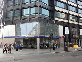
Tottenham Court Road is an interchange station in the West End of London for London Underground and Elizabeth line services.

Notting Hill Gate is a London Underground station near Notting Hill, London, located on the street called Notting Hill Gate. It is served by three lines: Central, Circle and District. On the Central line, the station is between Holland Park and Queensway stations. On the Circle and District lines, it is between High Street Kensington and Bayswater stations. It is on the boundary of Travelcard Zone 1 and Zone 2.

Bounds Green is a London Underground station, located at the junction of Bounds Green Road and Brownlow Road in Bounds Green in the London Borough of Haringey, North London. The station is on the Piccadilly line, between Wood Green and Arnos Grove stations, and is on the boundary between Zone 3 and Zone 4.

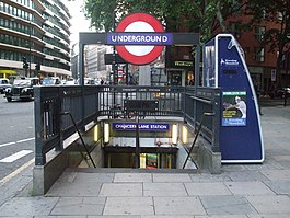
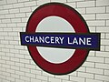
Holborn is a London Underground station in Holborn, Central London, located at the junction of High Holborn and Kingsway. It is served by the Central and Piccadilly lines and is located in Travelcard Zone 1. On the Central line the station is between Tottenham Court Road and Chancery Lane stations, and on the Piccadilly line it is between Covent Garden and Russell Square stations. Close by are the British Museum, Lincoln's Inn Fields, Red Lion Square, Bloomsbury Square, London School of Economics and Sir John Soane's Museum.

Oxford Circus is a London Underground station in Central London, serving Oxford Circus at the junction of Regent Street and Oxford Street, with entrances on all four corners of the intersection. The station is served by three lines: Bakerloo, Central and Victoria. As of 2023, it was the fourth-busiest station on the London Underground., and as such access to the station is frequently restricted at peak times. On the Bakerloo line the station is between Regent's Park and Piccadilly Circus stations, on the Central line it is between Bond Street and Tottenham Court Road stations, and on the Victoria line it is between Green Park and Warren Street stations. The station is in Travelcard Zone 1.

South Kensington is a London Underground station in the district of South Kensington, south west London. It is served by three lines: Circle, District and Piccadilly. On the Circle and District lines the station is between Gloucester Road and Sloane Square stations, and on the Piccadilly line it is between Gloucester Road and Knightsbridge stations. The station is located in Travelcard Zone 1. The main station entrance is located at the junction of Old Brompton Road (A3218), Thurloe Place, Harrington Road, Onslow Place and Pelham Street. Subsidiary entrances are located in Exhibition Road giving access by pedestrian tunnel to the Natural History, Science and Victoria and Albert Museums. Also close by are the Royal Albert Hall, Imperial College London, the Royal College of Music, the London branch of the Goethe-Institut and the Ismaili Centre.

Rayners Lane is a London Underground station in the district of Rayners Lane in north west London, amid a 1930s development originally named Harrow Garden Village. The station is on the Uxbridge branch of both the Metropolitan and Piccadilly lines. On the Metropolitan line, the station is between Eastcote and West Harrow stations. On the Piccadilly line, it is between Eastcote and South Harrow stations. The station is located to the west of the junction of Rayners Lane, Alexandra Avenue and Imperial Drive (A4090). It is in Travelcard Zone 5.

St Paul's is a London Underground station located in the City of London financial district. The station, which takes its name from the nearby St Paul's Cathedral, is on the Central line, between Chancery Lane and Bank stations, and is in fare zone 1.
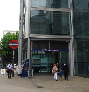
Euston Square is a London Underground station at the corner of Euston Road and Gower Street, just north of University College London – its main (south) entrance faces the tower of University College Hospital. The multi-interchange Euston station is beyond Euston Square Gardens, which is one street east. The station is between Great Portland Street and King's Cross St Pancras stations on the Circle, Hammersmith & City and Metropolitan lines in Travelcard Zone 1.
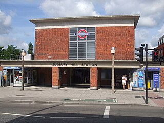
Sudbury Hill is a London Underground station in Sudbury, north-west London. It is on the Uxbridge branch of the Piccadilly line between South Harrow and Sudbury Town stations, and is in Travelcard Zone 4. The station is located on Greenford Road (A4127) north of the junction with Whitton Avenue, on the border between the London Boroughs of Harrow and Ealing. The station is close to Sudbury Hill Harrow railway station.

Alperton is a London Underground station in Alperton, north-west London. It is on the Uxbridge branch of the Piccadilly line between Sudbury Town and Park Royal stations, and is located in Travelcard Zone 4. It is located on Ealing Road (A4089), a short distance from the junction with Bridgewater Road (A4005), and is close to the Paddington branch of the Grand Union Canal.

Ealing Common is a London Underground station on the Uxbridge branch of the Piccadilly line and on the Ealing Broadway branch of the District line. Eastbound, the next station is Acton Town; westbound, the next station is North Ealing on the Piccadilly line and Ealing Broadway on the District line. Here, the District and Piccadilly lines share the same pair of tracks through the station – the only other example where a deep level line and a sub surface line share the same pair of tracks is further up the Uxbridge branch, where the Piccadilly line shares tracks with the Metropolitan line from Rayners Lane to Uxbridge. It is the only station west of Acton Town to be served by both the Piccadilly and District lines.
Park Royal is a London Underground station. It is on the Uxbridge branch of the Piccadilly line between Alperton and North Ealing stations and is in Travelcard Zone 3. It is situated on the south side of the east–west Western Avenue (A40), surrounded by residential Ealing and industrial Park Royal. There is a pedestrian subway under the A40 road near the station. Hanger Lane station on the Central line is within walking distance from this station.

Greenford is a London Underground and National Rail station in Greenford, Greater London, and is owned and managed by London Underground. It is the terminus of the National Rail Greenford branch line, 2 miles 40 chains down the line from West Ealing and 9 miles 6 chains measured from London Paddington. On the Central line, it is between Perivale and Northolt stations while on National Rail, the next station to the south on the branch is South Greenford.
Gants Hill is a London Underground station in the largely residential Gants Hill district of Ilford in east London. It is served by the Central line and is between Redbridge and Newbury Park stations on the Hainault loop. It is in Travelcard Zone 4. It is the easternmost station to be below ground on the London Underground network and the busiest on the Hainault loop.

North Acton is a London Underground station in North Acton, west London in the London Borough of Ealing. The station is on the Central line between East Acton and Hanger Lane on the West Ruislip Branch and West Acton on the Ealing Broadway Branch. It is on the boundary of Travelcard Zone 2 and Zone 3.
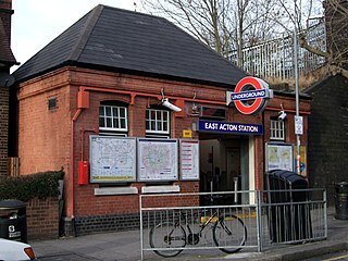
East Acton is a London Underground station in East Acton in London Borough of Hammersmith and Fulham. The station is on the Central line, between White City and North Acton stations, and in Travelcard Zone 2. Wormwood Scrubs, Queen Charlotte's and Chelsea Hospital, Hammersmith Hospital, Wormwood Scrubs prison and Imperial College Hammersmith branch are accessible from the station.

Shepherd's Bush is a London Underground station in the district of Shepherd's Bush in the London Borough of Hammersmith and Fulham. The station is on the Central line, between White City and Holland Park stations, and it lies in Travelcard Zone 2.

Sudbury Town is a London Underground station in Sudbury, north-west London. It is on the Uxbridge branch of the Piccadilly line between Sudbury Hill and Alperton stations, and is in Travelcard Zone 4. It is located on the border between the London Boroughs of Brent and Ealing, with its main entrance on Station Approach in Sudbury. The forecourt of the station is known as Station Crescent. The station serves Sudbury, which forms the western part of Wembley.

Paddington is a London Underground station in Paddington, London. It is located on Praed Street to the south of Paddington mainline station and has entrances from Praed Street and from within the mainline station. This station is served by three lines: Bakerloo, Circle and District. On the Bakerloo line the station is between Warwick Avenue and Edgware Road stations, and on the Circle and District lines it is between Bayswater and Edgware Road station. It is in London Fare Zone 1.