Leyton tube station

Last updated

Leyton Underground no-text.svg
Leyton stn building.JPG
Entrance on Leyton High Road (A112)
Greater London UK location map 2.svg
Red pog.svg
Leyton
Location of Leyton in Greater London
Location Leyton
Local authority London Borough of Waltham Forest
Managed by London Underground
Owner Transport for London
Number of platforms2
Fare zone 3
London Underground annual entry and exit
2018Decrease2.svg 12.04 million [1]
2019Decrease2.svg 11.26 million [2]
2020Decrease2.svg 7.33 million [3]
2021Decrease2.svg 5.29 million [4]
2022Increase2.svg 8.36 million [5]
Railway companies
Original company Eastern Counties Railway
Pre-grouping Great Eastern Railway
Post-grouping London and North Eastern Railway
Key dates
22 August 1856 (1856-08-22)Opened as Low Leyton
27 November 1867Renamed Leyton
5 May 1947Central line service introduced
6 May 1968Goods yard closed [6]
Other information
External links
WGS84 51°33′24″N0°00′19″W / 51.5566°N 0.0052°W / 51.5566; -0.0052
Underground sign at Westminster.jpg  London transportportal

Leyton is a London Underground station in Leyton, in the London Borough of Waltham Forest, East London. Located on Leyton High Road, adjacent to the A12, the station is on the Central line between Stratford and Leytonstone stations. It is in Travelcard zone 3.

Contents

Location

Leyton Mills Retail Park, Leyton Library, New Spitalfields Market, Leyton Orient F.C. stadium, and St. Patrick's Catholic Cemetery are within proximity of the station. Around Leyton station, the line runs parallel to the A12 road, while the station entrance is connected by the A112. It serves the area of the name itself, situated to the north of the A12 in the London Borough of Waltham Forest. Leyton is largely residential, [7] with houses built from 1870 to 1910. The origin of its name was derived from its geographical location, being at the "tun" of the river Lea, and the ancient parish was named Low Leyton. [8] [9] [note 1] To the south, it covers the Cathall housing estate in Leytonstone. [7]

History

The railway line from Loughton Branch Junction (on the Lea Valley line between Stratford and Lea Bridge} to Loughton was built by the Eastern Counties Railway, and opened on 22 August 1856. [11] A station at Leyton was opened on the same day, and was originally named Low Leyton. It was renamed Leyton on 27 November 1867 by the Great Eastern Railway. [12] [13] [14] The current station buildings largely date from the reconstruction of 1879, which saw the original level crossing replaced by a bridge, although some alterations were carried out in connection with the transfer of the station from the London & North Eastern Railway to London Underground as part of the eastern extensions of the Central line.

When the Central line (then known as the Central London Railway) was amalgamated under the management of London Passenger Transport Board in 1933, [15] plans for major expansions to the line were developed. [16] [note 2] The station was first served by the Central line on 5 May 1947, as part of the extension of the line to Leytonstone.

In the 1990s, the northern ticket office and entrance – dating from 1901 – were removed as part of the controversial M11 extension (now the A12) that was built adjacent to the station. In the mid-2000s, the station was comprehensively refurbished as part of the London Underground PPP. [17]

Planned upgrade and step free access

According to TfL, the station is severely overcrowded at peak periods, due to the small ticket hall (as a result of the station's location on top of the bridge over the tracks), and the proximity of the ticket barriers to the narrow pavement outside the station. [18] In 2011, it was announced the capacity of the station would be increased, in order to cope with the predicted additional users of the station during the 2012 Olympic Games, and to ease the existing congestion. This work would have created a new access to Goodall Road from the westbound platform. [19] [20] This work never materialised. [21]

In 2019, it was announced that Waltham Forest and Transport for London would fund a £18million expansion and upgrade of the station, including step free access. [22] [23] This work will involve construction of a new, larger ticket hall north of the current one, a new footbridge, wider stairs and step free access to both platforms. The existing ticket hall building would then be repurposed as a retail unit by TFL Property. [18] In 2020, a funding agreement between Waltham Forest and TFL was signed, with works estimated to begin in 2021 – with completion by 2023. [24] [25]

Services and connections

Eastbound platform looking west, with the curve towards the tunnel portal in the background. Leyton tube west.JPG
Eastbound platform looking west, with the curve towards the tunnel portal in the background.

Services

Leyton is between Stratford and Leytonstone stations on the London Underground Central line. The station is registered under Fare Zone 3, and sits between two adjacent stations assigned to two zones. [26] Trains generally operate between West Ruislip and Epping, and between Ealing Broadway and Hainault. The typical off-peak services, in trains per hour (tph) is: [27]

Night Tube services also operate at this station. Trains run every 10 minutes to Hainault via Newbury Park or Loughton eastbound, and to Ealing Broadway or White City westbound. [28]

Preceding station Underground no-text.svg London Underground Following station
Stratford Central line Leytonstone
Historical railways
Stratford
Line closed, station open
  Great Eastern Railway
Eastern Counties Railway
Loughton branch
  Leytonstone
Line and station open

Connections

London Buses routes 58, 69, 97 and 158 serve the station. [29]

Notes and references

Notes

  1. The prefix was subsequently dropped in 1921. [10]
  2. This was known as The 1935–40 New Works Programme. [16]

Related Research Articles

<span class="mw-page-title-main">Ealing Broadway station</span> London Underground and railway station

Ealing Broadway is a major single-level interchange station located in Ealing, in the London Borough of Ealing, West London for London Underground services and also Elizabeth line services on the National Rail Great Western Main Line.

<span class="mw-page-title-main">Aldgate East tube station</span> London Underground station

Aldgate East is a London Underground station on Whitechapel High Street in Whitechapel, in London, England. It takes its name from the City of London ward of Aldgate, the station lying to the east of the ward. It is on the Hammersmith & City line between Liverpool Street and Whitechapel, and on the District line between Tower Hill and Whitechapel, in Travelcard Zone 1.

<span class="mw-page-title-main">Barons Court tube station</span> London Underground station

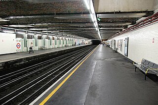
Barons Court is a London Underground station in West Kensington in the London Borough of Hammersmith and Fulham, Greater London. This station serves the District line and the Piccadilly line. Barons Court is between West Kensington and Hammersmith on the District line, and between Earl's Court and Hammersmith on the Piccadilly line and is in Travelcard Zone 2. East of the station, the Piccadilly line descends into tunnel towards Earl's Court and the District line continues in a cutting to West Kensington. The station is the last open air stop for eastbound trains on the Piccadilly line until Arnos Grove and has cross-platform interchange with the District line.

<span class="mw-page-title-main">Stepney Green tube station</span> London Underground station

Stepney Green is a London Underground station located on Mile End Road in Stepney, London, United Kingdom. It is between Whitechapel and Mile End on the District line and the Hammersmith & City line, and is in Travelcard Zone 2.

<span class="mw-page-title-main">Bow Road tube station</span> London Underground station

Bow Road is a London Underground station located on Bow Road in Bow, London, England. It is on the District and Hammersmith & City lines. The station is interlinked as an out of station interchange (OSI) with Bow Church station on the Docklands Light Railway which is about 300 m (980 ft) away via Bow Road. The two stations are classed as a single station for ticketing purposes as well as on tube maps but both are managed separately.

<span class="mw-page-title-main">Woodford tube station</span> London Underground station

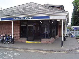
Woodford is a London Underground station in the town of Woodford in the London Borough of Redbridge, East London. The station is on the Central line, between South Woodford and Buckhurst Hill stations and is in Travelcard Zone 4. The station also acts as a terminus for services via the Hainault loop.

<span class="mw-page-title-main">Sudbury Hill tube station</span> London Underground station

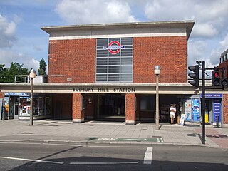
Sudbury Hill is a London Underground station on the Uxbridge branch of the Piccadilly line. The station is between Sudbury Town and South Harrow, and is in Travelcard Zone 4. It is located on Greenford Road (A4127) north of the junction with Whitton Avenue, on the border between the London Boroughs of Harrow and Ealing. The station is close to Sudbury Hill Harrow railway station.

<span class="mw-page-title-main">Park Royal tube station</span> London Underground station

Park Royal is a London Underground station. It is on the Piccadilly line between North Ealing and Alperton stations and is in Travelcard Zone 3. It is situated on the south side of the east–west Western Avenue (A40), surrounded by residential Ealing and industrial Park Royal. There is a pedestrian subway under the A40 road near the station.

<span class="mw-page-title-main">Leytonstone tube station</span> London Underground station

Leytonstone is a London Underground station in Leytonstone in the London Borough of Waltham Forest, east London. It is on the Central line, on the boundary of Zones 3 and 4. Towards Central London, the next station is Leyton, while going east from Leytonstone, the line divides into two branches. On the direct route to Woodford and Epping the next stop is Snaresbrook, and on the Hainault loop it is Wanstead. The station is close to Whipps Cross University Hospital. It is a terminus for some services and returns westbound.

<span class="mw-page-title-main">Loughton tube station</span> London Underground station

Loughton is a London Underground station in the Epping Forest district of Essex. It is entirely above ground, and platforms are accessed by staircases which rise from ground level.

<span class="mw-page-title-main">Greenford station</span> London Underground & National Rail station

Greenford is a London Underground and National Rail station in Greenford, Greater London, and is owned and managed by London Underground. It is the terminus of the National Rail Greenford branch line, 2 miles 40 chains down the line from West Ealing and 9 miles 6 chains measured from London Paddington. On the Central line, it is between Perivale and Northolt stations while on National Rail, the next station to the south on the branch is South Greenford.

<span class="mw-page-title-main">Gants Hill tube station</span> London Underground station

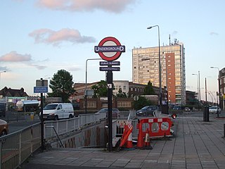
Gants Hill is a London Underground station in the largely residential Gants Hill district of Ilford in East London. It is served by the Central line and is between Redbridge and Newbury Park stations on the Hainault loop. It is in Travelcard Zone 4. It is the easternmost station to be below ground on the London Underground network and the busiest on the Hainault loop.

<span class="mw-page-title-main">East Acton tube station</span> London Underground station

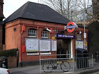
East Acton is a London Underground station in East Acton in London Borough of Hammersmith and Fulham. The station is on the Central line, between White City and North Acton stations, and in Travelcard Zone 2. Wormwood Scrubs, Queen Charlotte's and Chelsea Hospital, Hammersmith Hospital, Wormwood Scrubs prison and Imperial College Hammersmith branch are accessible from the station.

<span class="mw-page-title-main">Sudbury Town tube station</span> London Underground station

Sudbury Town is a London Underground station on the Uxbridge branch of the Piccadilly line. The station is between Alperton and Sudbury Hill, and is in Travelcard Zone 4. It is located on the border between the London Boroughs of Brent and Ealing, with its main entrance on Station Approach in Sudbury. The forecourt of the station is known as Station Crescent. The station serves Sudbury, which forms the western part of Wembley.

<span class="mw-page-title-main">North Ealing tube station</span> London Underground station

North Ealing is a London Underground station on the Uxbridge branch of the Piccadilly line between Ealing Common and Park Royal. The station is located on Station Road, a short distance from the junction of Queen's Drive and Hanger Lane. It is in Travelcard Zone 3. West Acton station on the Central line is located about 550 metres to the east at the other end of Queen's Drive.

<span class="mw-page-title-main">Newbury Park tube station</span> London Underground station

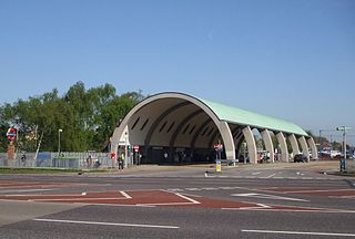
Newbury Park is a London Underground station in Newbury Park, Ilford, East London. It is between Barkingside and Gants Hill stations on the Hainault loop of the Central line, in Travelcard Zone 4. The station was initially opened by the Great Eastern Railway on 1 May 1903 and subsequently transferred its services to the London & North Eastern Railway due to the amalgamation. Underground trains only started serving the station on 14 December 1947, operating via the Gants Hill tunnel. The line was extended to Hainault on 31 May 1948. The Grade II listed bus shelter designed by Oliver Hill opened on 6 July 1949. Lifts were fully installed at Newbury Park in November 2018 to provide step-free access to the station, approximately 10 years after TfL abandoned the project.

<span class="mw-page-title-main">Redbridge tube station</span> London Underground station

Redbridge is a London Underground station on Eastern Avenue in the Redbridge district of Ilford in North East London, on the Hainault Loop of the Central line, in Zone 4. It opened on 14 December 1947 as an extension of the Central line to form the new part of the Hainault loop.

<span class="mw-page-title-main">Barkingside tube station</span> London Underground station

Barkingside is a London Underground station on the Central line. It is on the eastern edge of Barkingside in east London at the end of a cul-de-sac off Station Road. The station is next door to the home of Redbridge F.C. It is between Newbury Park and Fairlop stations and has been in Travelcard Zone 4 since 2 January 2007.

<span class="mw-page-title-main">Hainault tube station</span> London Underground station

Hainault is a London Underground station in Hainault, east London, England. The station is on the Central line between Fairlop and Grange Hill stations. Since 2 January 2007, the station has been in Travelcard Zone 4. It is also home to one of the three Central line depots.

<span class="mw-page-title-main">Debden tube station</span> London Underground station

Debden is a London Underground station on the Central line in the east of Loughton, in the Epping Forest district of Essex. The station is between Loughton and Theydon Bois. It is located in Station Approach off Chigwell Lane (A1168) and is in Travelcard Zone 6.

References

  1. "Station Usage Data" (CSV). Usage Statistics for London Stations, 2018. Transport for London. 23 September 2020. Archived from the original on 14 January 2023. Retrieved 11 October 2023.
  2. "Station Usage Data" (XLSX). Usage Statistics for London Stations, 2019. Transport for London. 23 September 2020. Archived from the original on 9 November 2020. Retrieved 9 November 2020.
  3. "Station Usage Data" (XLSX). Usage Statistics for London Stations, 2020. Transport for London. 16 April 2021. Retrieved 1 January 2022.
  4. "Station Usage Data" (XLSX). Usage Statistics for London Stations, 2021. Transport for London. 12 July 2022. Retrieved 7 September 2022.
  5. "Station Usage Data" (XLSX). Usage Statistics for London Stations, 2022. Transport for London. 4 October 2023. Retrieved 10 October 2023.
  6. Hardy, Brian, ed. (March 2011). "How it used to be – freight on The Underground 50 years ago". Underground News (591). London Underground Railway Society: 175–183. ISSN   0306-8617.
  7. 1 2 "Google Maps" (Map). Leyton Tube Station . Retrieved 3 July 2020.
  8. Ordnance Survey Map 2½" (Map) (6" ed.). 1:50000. Leyton: P.N. Essex (E.P.N.S.), 102. 1952. p. 180. § TQ 38.
  9. Powell, W. R. (1973). Leyton: Introduction. A History of the County of Essex. Vol. 6. London: British History Online (Victoria County History). pp. 174–184. Archived from the original on 3 July 2020. Retrieved 3 July 2020.
  10. Census (County of Essex), 1911, 1921
  11. Allen, Cecil J. (1956) [1955]. The Great Eastern Railway (2nd ed.). Hampton Court: Ian Allan. pp. 20, 216.
  12. Chronology of London Railways by H.V.Borley page69
  13. Forgotten Stations of Greater London by J.E.Connor and B.Halford page 124
  14. Butt, R.V.J. (1995). The Directory of Railway Stations. Yeovil: Patrick Stephens Ltd. pp. 142, 150. ISBN   1-85260-508-1. R508.
  15. Day & Reed 2010, p. 212.
  16. 1 2 Day & Reed 2010, p. 116.
  17. "Waltham Forest to benefit as Mayor unveils £10bn investment programme to transform Londons transport network". Transport for London. 12 October 2004. Retrieved 28 April 2020.
  18. 1 2 "Leyton Underground Station - Council funding contribution towards proposed capacity improvement and Step Free Access scheme" (PDF). London Borough of Waltham Forest . 17 January 2019.
  19. Jackson-Obot, Ima (13 September 2011). "LEYTON: Station capacity to double". East London and West Essex Guardian. Retrieved 28 April 2020.
  20. Binns, Daniel (26 May 2012). "LEYTON: Thousands to use station during Olympics". East London and West Essex Guardian Series. Retrieved 28 April 2020.
  21. "'Our Olympics': (1) LBWF and Leyton Market - the Council wins a 'gold medal for ineptitude'". Waltham Forest Matters. 8 April 2015. Retrieved 29 April 2020.
  22. Richardson, Alice (18 January 2019). "Step-free access planned for Leyton tube station". East London and West Essex Guardian. Retrieved 28 April 2020.
  23. "Cabinet decision – LEYTON UNDERGROUND STATION: CAPACITY IMPROVEMENT AND STEP FREE ACCESS SCHEME". democracy.walthamforest.gov.uk. 18 October 2018. Retrieved 28 April 2020.
  24. "Leyton Underground Station: Funding Agreement with Transport for London" (PDF). London Borough of Waltham Forest . 16 March 2020.
  25. Munro, Victoria (10 March 2020). "Leyton Tube station expansion could start by August next year". East London and West Essex Guardian. Retrieved 28 April 2020.
  26. Standard Tube Map (PDF) (Map). Not to scale. Transport for London. November 2022. Archived (PDF) from the original on 7 November 2022. Retrieved 12 November 2022.
  27. Clive, Feather (8 May 2020). "Central Line". Clive's Underground Line Guides. Archived from the original on 7 July 2020. Retrieved 7 July 2020.
  28. "The Night Tube". Improving the Tube – What We're Doing. Transport for London. Archived from the original on 7 July 2020. Retrieved 6 February 2018.
  29. "Buses from Leyton Station" (PDF). TfL. 26 August 2023. Retrieved 5 February 2024.

Bibliography