Marble Arch

Last updated

The arch with The Cumberland Hotel, Great Cumberland Place and the trees of Bryanston Square beyond, parts of the British Regency-architecture Portman Estate Marble Arch (29797251968).jpg
The arch with The Cumberland Hotel, Great Cumberland Place and the trees of Bryanston Square beyond, parts of the British Regency-architecture Portman Estate

The Marble Arch is a 19th-century white marble-faced triumphal arch in London, England. The structure was designed by John Nash in 1827 as the state entrance to the cour d'honneur of Buckingham Palace; it stood near the site of what is today the three-bayed, central projection of the palace containing the well-known balcony. [1] In 1851, on the initiative of architect and urban planner Decimus Burton, a one-time pupil of John Nash, the arch was relocated to its current site, near the northeast corner of Hyde Park, so that expansion of Buckingham Palace could proceed.

Contents

The arch gives its name to the area surrounding it, particularly the southern portion of Edgware Road and also to the underground station. The arch is not part of the Royal Parks and is maintained by Westminster City Council.

Design and construction

Model of John Nash's original design for the arch, now in the Victoria and Albert Museum in London Nashvanda.jpg
Model of John Nash's original design for the arch, now in the Victoria and Albert Museum in London

Nash's three-arch design is based on that of the Arch of Constantine in Rome and the Arc de Triomphe du Carrousel in Paris. [2] [3] The triumphal arch is faced with Carrara marble with embellishments of marble extracted from quarries near Seravezza in Tuscany.

John Flaxman was chosen to make the commemorative sculpture. After his death in 1826, the commission was divided between Sir Richard Westmacott, Edward Hodges Baily and J. C. F. Rossi. In 1829, a bronze equestrian statue of George IV was commissioned from Sir Francis Chantrey, with the intention of placing it on top of the arch. [4]

Construction began in 1827, but was cut short in 1830, following the death of the spendthrift King George IV – the rising costs were unacceptable to the new king, William IV, who later tried to offload the uncompleted palace onto Parliament as a substitute for the recently destroyed Palace of Westminster. [5]

Work restarted in 1832, this time under the supervision of Edward Blore, who greatly reduced Nash's planned attic stage and omitted its sculpture, including the statue of George IV. The arch was completed in 1833. [1]

Some of the unused sculpture, including parts of Westmacott's frieze of Waterloo and the Nelson panels, were used at Buckingham Palace. His victory statues and Rossi's relief of Europe and Asia were used at the National Gallery. In 1843 the equestrian statue of George IV was installed on one of the pedestals in Trafalgar Square. [1]

The white marble soon lost its light colouring in the polluted London atmosphere. In 1847, Sharpe's London Magazine described it as "discoloured by smoke and damp, and in appearance resembling a huge sugar erection in a confectioner's shop window." [6]

The arch is 45 feet (14 m) high, [7] and measures 60 by 30 feet (18.3 by 9.1 m) east-west by north–south. [1]

Relocation

Marble Arch (left) before its relocation to Hyde Park in 1847. It was constructed in 1832-1833, as the ceremonial entrance to the newly rebuilt Buckingham Palace courtyard Buckingham Palace engraved by J.Woods after Hablot Browne & R.Garland publ 1837 edited.jpg
Marble Arch (left) before its relocation to Hyde Park in 1847. It was constructed in 1832–1833, as the ceremonial entrance to the newly rebuilt Buckingham Palace courtyard

Buckingham Palace remained unoccupied, and for the most part unfinished, until it was hurriedly completed upon the accession of Queen Victoria in 1837. Within a few years, it was deemed that the palace was too small to accommodate the large court and the Queen's expanding family. The solution was to enlarge the palace by enclosing the cour d'honneur with a new east range. This façade is today the principal front and public face of the palace and shields the inner façades containing friezes and marbles matching and complementing those of the arch.

When building work began in 1847, the arch was dismantled and rebuilt by Thomas Cubitt as a ceremonial entrance to the northeast corner of Hyde Park at Cumberland Gate. [8] The reconstruction was completed in March 1851. [1] A popular story says that the arch was moved because it was too narrow for the Queen's state coach to pass through, but, in fact, the Gold State Coach passed under it during Elizabeth II's coronation in 1953. [9]

Three small rooms inside the rebuilt arch were used as a police station from 1851 until at least 1968 (John Betjeman made a television programme inside it in 1968 and referred to it as a fully functional police station). [10] It firstly housed officers of the Royal Parks Constabulary and later the Metropolitan Police. One policeman stationed there during the early 1860s was Samuel Parkes, who won the Victoria Cross in the Charge of the Light Brigade in 1854, during the Crimean War.

Park Lane widening

Nic Fiddian-Green's Still Water, with Marble Arch in the background Still Water Marble Arch 2020 (1).jpg
Nic Fiddian-Green's Still Water , with Marble Arch in the background

Park Lane was widened as part of the Park Lane Improvement Scheme of the London County Council, and the Marble Arch became stranded on a traffic island. The scheme required an act of Parliament – the Park Lane Improvement Act 1958 (6 & 7 Eliz. 2. c. 63) – and during the passage of this act the possibility of providing an underpass instead of a roundabout was dismissed due to excessive cost and the need to demolish buildings on Edgware Road. [11] As part of the scheme, gardens were laid out around the arch on the traffic island. [12] The works took place between 1960 and 1964. [13]

Still Water , a large bronze sculpture of a horse's head by Nic Fiddian-Green, was unveiled on the same traffic island a short distance from the arch in 2011.

In 2005 it was speculated that the arch might be moved across the street to Hyde Park, or to a more accessible location than its position on what was then a large traffic island. [14]

Marble Arch area

Aerial view of the arch and its surroundings Marble Arch - geograph.org.uk - 1512461.jpg
Aerial view of the arch and its surroundings

In 1900 the Central London Railway opened Marble Arch tube station across the road from the arch. The station is now on the Central line of the London Underground.

Having a tube station means that the arch gives rise to a colloquial, entirely modern London "area", with no parishes or established institutions bearing its name. This generally equates to parts in view of the arch of Mayfair, Marylebone and often all of St George's Fields, Marylebone (west of Edgware Road) all in the City of Westminster, London, W1H.

The area around the arch forms a major road junction connecting Oxford Street to the east, Park Lane (A4202) to the south, Bayswater Road (A402) to the west, and Edgware Road (A5) to the north-west. The short road directly to the north of the arch is also known as Marble Arch.

The former cinema Odeon Marble Arch was located directly adjacent to the junction. Before 1997 this had the largest cinema screen in London. The screen was originally over 75 feet (23 m) wide. The Odeon showcased 70 mm films in a large circle-and-stalls auditorium. It closed in 2016 and was demolished later that same year.

The arch also stands close to the former site of the Tyburn gallows (sometimes called "Tyburn Tree"), a place of public execution from 1388 until 1793.

In 2021 the Marble Arch Mound, a temporary viewing platform, was opened at the site. [15]

Sculptures intended for the arch used elsewhere

Related Research Articles

<span class="mw-page-title-main">Charing Cross</span> The point from which distances from London are measured

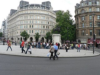
Charing Cross is a junction in Westminster, London, England, where six routes meet. Since the early 19th century, Charing Cross has been the notional "centre of London" and became the point from which distances from London are measured. Clockwise from north, the routes that meet at Charing Cross are the east side of Trafalgar Square leading to St Martin's Place and then Charing Cross Road; the Strand leading to the City; Northumberland Avenue leading to the Thames Embankment; Whitehall leading to Parliament Square; The Mall leading to Admiralty Arch and Buckingham Palace; and two short roads leading to Pall Mall.

<span class="mw-page-title-main">Paddington</span> Area of central London, England

Paddington is an area in the City of Westminster, in central London, England. A medieval parish then a metropolitan borough, it was integrated with Westminster and Greater London in 1965. Paddington station, designed by the engineer Isambard Kingdom Brunel opened in 1847. It is also the site of St Mary's Hospital and the former Paddington Green Police Station.

<span class="mw-page-title-main">Edward Hodges Baily</span> English sculptor (1788–1867)

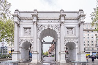
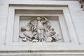
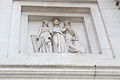
Edward Hodges Baily was a prolific British sculptor responsible for numerous public monuments, portrait busts, statues and exhibition pieces as well as works in silver. He carved friezes for both the Marble Arch and Buckingham Palace in London. His numerous statues of public figures include that of Horatio Nelson on top of Nelson's Column and Charles Grey, 2nd Earl Grey on Grey's Monument in Newcastle upon Tyne. Throughout his career Baily was responsible for creating a number of monuments and memorials for British churches and cathedrals, including several in St Paul's Cathedral.

<span class="mw-page-title-main">Park Lane</span> Road in London

Park Lane is a dual carriageway road in the City of Westminster in Central London. It is part of the London Inner Ring Road and runs from Hyde Park Corner in the south to Marble Arch in the north. It separates Hyde Park to the west from Mayfair to the east. The road has a number of historically important properties and hotels and has been one of the most sought after streets in London, despite being a major traffic thoroughfare.

<span class="mw-page-title-main">Hyde Park, London</span> Royal Park in London, United Kingdom

Hyde Park is a 350 acres (140 ha), historic Grade I-listed urban park in Westminster, Greater London. A Royal Park, it is the largest of the parks and green spaces that form a chain from Kensington Palace through Kensington Gardens and Hyde Park, via Hyde Park Corner and Green Park, past Buckingham Palace to St James's Park. Hyde Park is divided by the Serpentine and the Long Water lakes.

<span class="mw-page-title-main">Hyde Park Corner</span> Road junction in London, England

Hyde Park Corner is between Knightsbridge, Belgravia and Mayfair in London, England. It primarily refers to a major road junction at the southeastern corner of Hyde Park, that was originally planned by architect Decimus Burton. The junction includes a broad green-space roundabout in its centre, which is now the setting for Burton's triumphal Wellington Arch.

<span class="mw-page-title-main">Constitution Hill, London</span> Historic road in the City of Westminster, London

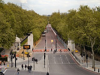
Constitution Hill is a road in the City of Westminster in London. It connects the western end of The Mall with Hyde Park Corner, and is bordered by Buckingham Palace Gardens to the south, and Green Park to the north. At the top of the rise in the roadway at the Corner is the Wellington Arch, near where the road is flanked by the Memorial Gates war memorial.

<span class="mw-page-title-main">St James's Park</span> Royal Park in the City of Westminster, central London

St James's Park is a 23-hectare (57-acre) urban park in the City of Westminster, central London. A Royal Park, it is at the southernmost end of the St James's area, which was named after a once isolated medieval hospital dedicated to St James the Less, now the site of St James's Palace. The area was initially enclosed for a deer park near the Palace of Whitehall for King Henry VIII in the 1530's. It is the most easterly of a near-continuous chain of public parks that includes Green Park, Hyde Park, and Kensington Gardens.

<span class="mw-page-title-main">Connaught Square</span> Square in London, England

Connaught Square in London, England, was the first square of city houses to be built in Bayswater. It is named after a royal, the Earl of Connaught who was from 1805 until death in 1834 the second and last Duke of Gloucester and Edinburgh, and who maintained his fringe-of-London house and grounds on the land of this square and Gloucester Square. Its appearance is essentially the same as in the 1820s. Its south-east is 115 metres north of Hyde Park and the same west of Edgware Road. This point is 302 m (991 ft) WNW of Marble Arch, which sits on a very large green roundabout marking the western end of Oxford Street. Connaught Street runs along is northern end.

<span class="mw-page-title-main">Wellington Arch</span> Triumphal arch in London

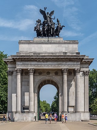
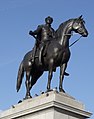
The Wellington Arch, also known as the Constitution Arch or (originally) as the Green Park Arch, is a Grade I-listed triumphal arch by Decimus Burton that forms a centrepiece of Hyde Park Corner in central London, between the corner where Hyde Park meets Green Park. The Arch stands on a large green-space traffic island with crossings for pedestrian access. From its construction (1826–1830) the arch stood in a nearby location, slightly to the east, directly across from Burton's Ionic screen entrance to Hyde Park; it was moved a short distance to its current site at the top of the Constitution Hill road in 1882–1883. The triumphal arch originally supported a colossal equestrian statue of the 1st Duke of Wellington by the sculptor Matthew Cotes Wyatt, acquiring its name as a result. Peace descending on the Quadriga of War by sculptor Adrian Jones, a bronze of the Goddess of Victory Nike riding a quadriga, has surmounted the arch since 1912.

<span class="mw-page-title-main">Bayswater Road</span> Road in west London, running along the northern boundary of Hyde Park

Bayswater Road is the main road running along the northern edge of Hyde Park in London. Originally part of the A40 road, it is now designated part of the A402 road.

<span class="mw-page-title-main">Richard Westmacott</span> British sculptor

Sir Richard Westmacott was a British sculptor.

<span class="mw-page-title-main">Waterloo Vase</span>

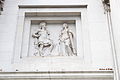
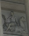
The Waterloo Vase is a 15-foot (4.6 m) stone urn, situated in the garden of Buckingham Palace in central London. Fashioned from a single piece of Carrara marble, it was initially presented to Napoleon I, who intended to have it carved in celebration of anticipated future military victories. After the Emperor’s defeat at the Battle of Waterloo, the uncarved vase was given to the Prince Regent, later George IV. The Prince commissioned the sculptor, Richard Westmacott to decorate the vase with reliefs celebrating the victory at Waterloo. The original plan to place the vase in the Waterloo Gallery at Windsor Castle proved unrealisable, the weight of the vase being greater than the gallery’s floors could bear. It was therefore given to the National Gallery in Trafalgar Square. Considering the vase surplus to its requirements, the gallery placed it first in Hyde Park, London and then into storage at the Victoria and Albert Museum. In 1903, it was offered by the museum to the new king, Edward VII, who installed it as a garden ornament in the grounds of Buckingham Palace, where it remains. The vase is a Grade I listed structure.

<span class="mw-page-title-main">John Edward Carew</span>

John Edward Carew was a notable Irish sculptor during the 19th century. His most prominent work is The Death of Nelson, one of the four bronze panels on the pedestal of Nelson's Column in Trafalgar Square.

<span class="mw-page-title-main">A40 road in London</span> Major trunk road connecting London to Fishguard, Wales

The A40 is a major trunk road connecting London to Fishguard, Wales. The A40 in London starts in the City of London and passes through six London Boroughs: Camden, Westminster, Kensington & Chelsea, Hammersmith & Fulham, Ealing and Hillingdon, to meet the M40 motorway junction 1 at Denham, Buckinghamshire.

<span class="mw-page-title-main">Marylebone</span> Area in London, England

Marylebone is an area in London, England and is located in the City of Westminster. It is in Central London and part of the West End. Oxford Street forms its southern boundary.

<span class="mw-page-title-main">Equestrian statue of George IV, Trafalgar Square</span> Sculpture by Francis Legatt Chantrey

The statue of George IV in Trafalgar Square, London, is a bronze equestrian statue by Sir Francis Legatt Chantrey. It depicts the King dressed in ancient Roman attire and riding bareback. The sculpture was originally designed to sit on top of the Marble Arch at the entrance to Buckingham Palace, but was placed in its current location following the King's death.

<span class="mw-page-title-main">Eia</span> Former Medieval manor in Middlesex, England

Eia or Eye was an early Medieval manor in Westminster, Middlesex and is now a part of Central London. It was about one mile west of the Palace of Westminster/Whitehall, about 2 miles west-south-west of the walled City of London, and about half a mile north of the River Thames.

References

Citations

  1. 1 2 3 4 5 "Pastscape-Detailed Result". English Heritage. Retrieved 7 October 2011.
  2. Weinreb et al. 2008, p. 528.
  3. Timbs, John (1868). London and Westminster: City and Suburb. London. pp. 190–91.{{cite book}}: CS1 maint: location missing publisher (link)
  4. Cunningham, Peter (1850). Handbook of London: Past and Present. Vol. 1. London: John Murray. p. 511.
  5. Ziegler, Phillip (1971). King William IV. Collins. p. 280. ISBN   0-00-211934-X.
  6. "A Little Talk About Buckingham Palace". Sharpe's London Magazine. 13 (4): 355. 1847.
  7. "Memorial: Marble Arch". London Remembers. Retrieved 3 May 2019.
  8. Holland & Hannen and Cubitts – The Inception and Development of a Great Building Firm, published 1920, p. 35
  9. "Coronation route" . Retrieved 21 September 2011.
  10. "Marble Arch to Edgware". BBC TV. 1968. Retrieved 21 February 2020.
  11. "Park Lane Improvement Bill (1958)". Parliamentary Debates (Hansard) . House of Lords. 17 June 1958. Retrieved 29 April 2020.
  12. Marble Arch, London Gardens Trust. Accessed: 13 August 2021.
  13. Smith, Denis, ed. (2001). London and the Thames Valley. London: Institution of Civil Engineers / Thomas Telford. ISBN   9780727728760.
  14. "Marooned Marble Arch may be moved". BBC News. 28 February 2005. Retrieved 21 September 2011.
  15. Prynn, Jonathan (24 June 2021). "Marble Arch's £2m mound is mounting up for summer". Evening Standard. London.

Sources

Commons-logo.svg Media related to Marble Arch at Wikimedia Commons

51°30′47″N0°09′32″W / 51.51317°N 0.15888°W / 51.51317; -0.15888