This is a list of public art in the London Borough of Havering .
This is a list of public art in the London Borough of Havering .
| Image | Title / subject | Location and coordinates | Date | Artist / designer | Type | Designation | Notes |
|---|---|---|---|---|---|---|---|
 | The Diver:Regeneration | Coldharbour 51°29′51″N0°10′57″E / 51.4974°N 0.1824°E | 2000 | John Kaufman | Statue | — |
| Image | Title / subject | Location and coordinates | Date | Artist / designer | Type | Designation | Notes |
|---|---|---|---|---|---|---|---|
| Harold Hill War Memorial | Hilldene Avenue, Harold Hill 51°36′26″N0°13′05″E / 51.6071°N 0.2180°E | 1998 | Hammond and Partners | Memorial stone | — | [1] | |
| The Art of Recycling | Outside Harold Hill Library, Hilldene Avenue, Harold Hill 51°36′27″N0°13′06″E / 51.6076°N 0.2184°E | 2003 | Mark Wydler, Karen Wydler and Carrie Reichardt | Mural | — | [2] | |
 | Sustrans Portrait Bench | Central Park, Harold Hill 51°36′26″N0°13′43″E / 51.6071°N 0.2286°E | 2011 | ? | Sculpture | — | Depicts Henry VIII, Dick Bouchard (founder of the Romford Drum & Trumpet Corps), and Harry Eccleston. [3] [4] |
| Image | Title / subject | Location and coordinates | Date | Artist / designer | Type | Designation | Notes |
|---|---|---|---|---|---|---|---|
 | Bull's head | St Andrew's Church 51°33′37″N0°13′35″E / 51.5604°N 0.2264°E | c. 1824 | Architectural sculpture | [5] | ||
 | Hornchurch War Memorial | Upminster Road, near St Andrew's Church 51°33′39″N0°13′32″E / 51.5608°N 0.2255°E | 1921 | Charles A. Nicholson | Memorial cross | — | [6] |
| Image | Title / subject | Location and coordinates | Date | Artist / designer | Type | Material | Designation | Notes |
|---|---|---|---|---|---|---|---|---|
 More images | Rainham War Memorial | Rainham town centre 51°31′07″N0°11′25″E / 51.518611°N 0.190278°E | 1920 | Mr Vinton (builder) | Clock tower | Grade II | [7] | |
| Litmus Towers | A13, Marsh Way and Ferry Lane junctions | 2005 | Jason Bruges Studio | Sculpture | Galvanised Steel & Aluminium | Four towers. Each displays different data via LEDs. [8] [9] | ||
| Railing Hall | Viking Way Passage | 2010 | Mark Pimlott | Installation | [10] [11] | |||
| Wildspace Warehouse | Ferry Lane North | 2011 | Alison Brooks | Cladding | Industrial warehouses alongside the High Speed 1 tracks. [10] | |||
| Rainham Tokens | Bridge Road, Broadway & Upminster Road South | 2012 | Elaine Tribley, Amanda Westbury | Medallions | Bronze | Twelve tokens set into the pavement. [12] [13] | ||
| Mural | Viking Way Passage | 2012 | Painter: Peter O'Connor, Design: Objectif (Marta dos Santos, Gaetan Billault) | Mural | Paint | [10] | ||
| Cardinal Seat | Rainham town centre | 2013 | Mark Pimlott | Bench | [11] | |||
| Orchard Fruit | Orchard Village Community Square | 2015 | Andrew McKeown | Sculpture | Bronze | Seven separate pieces of varying dimensions. [14] | ||
| Flightway | Ingrebourne Hill, near Lake Stillwell | Sculpture |
| Image | Title / subject | Location and coordinates | Date | Artist / designer | Type | Designation | Notes |
|---|---|---|---|---|---|---|---|
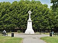 More images | Romford War Memorial | Coronation Gardens (originally in Laurie Square; moved here in 1969) 51°34′53″N0°11′07″E / 51.5814°N 0.1852°E | 1921 | J. W. Hammond | Memorial cross | Grade II | [15] |
| Image | Title / subject | Location and coordinates | Date | Artist / designer | Type | Designation | Notes |
|---|---|---|---|---|---|---|---|
 | Upminster War Memorial | St Laurence's Church, Corbets Tey Road | 1921 | Memorial cross | Grade II | [16] |