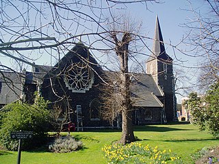
Erith is an area in south-east London, England, 13.3 miles (21.4 km) east of Charing Cross. Within the historic county of Kent, it has formed part of the London Borough of Bexley since 1965. It lies north-east of Bexleyheath and north-west of Dartford, on the south bank of the River Thames. The population is 45,345. The town centre has been modernised with further dwellings added since 1961. The curved riverside high street has three listed buildings, including the Church of England church and the Carnegie Building. Erith otherwise consists mainly of suburban housing. It is linked to central London and Kent by rail and to Thamesmead by a dual carriageway. It has the longest pier in London, and retains a coastal environment with salt marshes alongside industrial land.

Hornchurch is a suburban town in East London, England, and part of the London Borough of Havering. It is located 15.2 miles (24.5 km) east-northeast of Charing Cross. It comprises a number of shopping streets and a large residential area. It historically formed a large ancient parish in the county of Essex that became the manor and liberty of Havering. The economic history of Hornchurch is underpinned by a shift away from agriculture to other industries with the growing significance of nearby Romford as a market town and centre of administration. As part of the suburban growth of London in the 20th century, Hornchurch significantly expanded and increased in population, becoming an urban district in 1926 and has formed part of Greater London since 1965. It is the location of Queen's Theatre, Havering Sixth Form College and Havering College of Further and Higher Education.

Thamesmead is an area of south-east London, England, straddling the border between the Royal Borough of Greenwich and the London Borough of Bexley. It is located 11 miles (18 km) east of Charing Cross, north-east of Woolwich and west of Erith. It mainly consists of social housing built from the mid-1960s onwards on former marshland on the south bank of the River Thames.

The London Borough of Havering in East London, England, forms part of Outer London. It has a population of 259,552 inhabitants; the principal town is Romford, while other communities are Hornchurch, Upminster, Collier Row and Rainham. The borough is mainly suburban, with large areas of protected open space. Romford is a major retail and night time entertainment centre, and to the south the borough extends into the London Riverside redevelopment area of the Thames Gateway. The name Havering is a reference to the Royal Liberty of Havering which occupied the area for several centuries. The local authority is Havering London Borough Council. It is the easternmost London borough.

The London Borough of Bexley is a London borough in south-east London, forming part of Outer London. It has a population of 248,287. The main settlements are Sidcup, Erith, Bexleyheath, Crayford, Welling and Old Bexley. The London Borough of Bexley is within the Thames Gateway, an area designated as a national priority for urban regeneration. The local authority is Bexley London Borough Council.
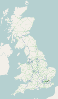
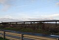
The A13 is a major road in England linking Central London with east London and south Essex. Its route is similar to that of the London, Tilbury and Southend line via Rainham, Grays, Tilbury & Stanford-Le-Hope, and runs the entire length of the northern Thames Gateway area, terminating on the Thames Estuary at Shoeburyness. It is a trunk road between London and the Tilbury junction, a primary route between there and Sadlers Hall Farm near South Benfleet, and a non-primary route between there and Shoeburyness.

Tilbury is a town in the borough of Thurrock, Essex, England. The present town was established as separate settlement in the late 19th century, on land that was mainly part of Chadwell St Mary. It contains a 16th century fort and an ancient cross-river ferry. Tilbury is part of the Port of London with a major deep-water port which contributes to the local economy.
Belvedere is a town in south-east London, England, within the London Borough of Bexley. It lies close to the River Thames, with Erith to the east, Bexleyheath to the south, and Abbey Wood and Thamesmead to the west. Prior to the creation of Greater London in 1965, Belvedere was in the administrative county of Kent.
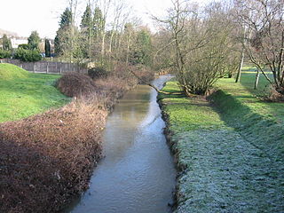
The River Ingrebourne is a tributary of the River Thames 27 miles (43.3 km) in length. It is considered a strategic waterway in London, forming part of the Blue Ribbon Network. It flows through the London Borough of Havering roughly from north to south, joining the Thames at Rainham.

Wennington is a small village and former civil parish in the London Borough of Havering, within the Metropolitan Green Belt. It is situated 14.8 miles (23.8 km) east of Charing Cross.

Slade Green is an area of South East London, England, within the London Borough of Bexley and the historic county of Kent. It lies northeast of Bexleyheath, northwest of Dartford and south of Erith, and 14 miles (23 km) east-southeast of Charing Cross.

The London Riverside is a redevelopment area on the north side of the River Thames in East London, England and part of the larger Thames Gateway redevelopment zone. The London Riverside area forms part of the Green Enterprise District, a project to create a low-carbon economy region in Greater London. Land available for redevelopment is owned by GLA Land and Property. From 2004 to 2013 the redevelopment of London Riverside and the Lower Lea Valley was the responsibility of the London Thames Gateway Development Corporation. There is also a London Riverside business improvement district which covers a smaller area.
South Hornchurch is a locality to the south of Hornchurch in London Borough of Havering, east London. It is a suburban development situated 13.6 miles (21.8 km) east of Charing Cross. The area is a relatively recent addition, compared with the more mature suburbs in Havering. It was built on open farmland and the former site of RAF Hornchurch.

Rainham Marshes is an RSPB nature reserve in the east of London, adjacent to the Thames Estuary in Purfleet, Thurrock and the London Borough of Havering. In 2000, the area of land was bought from the Ministry of Defence, who used it as a test firing range. With no activity for several years, the nature reserve was officially opened to the public in 2006. It has maintained much of its medieval landscape, and is the largest area of wetland on the upper parts of the Thames Estuary.
The Wildspace Conservation Park, also known as London Riverside Conservation Park or Wildspace, is a major new conservation park under development. The conservation park is predominantly in London, within the London Borough of Havering, but also extends across the capital's administrative boundary and into Thurrock in Essex. It covers much of the Rainham Marshes near to Rainham and Wennington and its area is 645 hectares.

The Diver is a sculpture by John Kaufman located in the River Thames at Rainham, east London. The Diver is made of galvanised steel bands on a steel frame and is 15 feet (4.6 m) tall and approximately 6 feet (1.8 m) wide and is partly submerged every high tide and totally submerged by spring and neap tides.

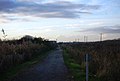
National Cycle Route 1 is a route of the National Cycle Network, running from Dover to Tain. The 1,022 km-long (635-mile) cycle-path is located in the United Kingdom.

Rainham is a suburb of East London, England, in the London Borough of Havering. Rainham is 13.6 miles (21.9 km) east of Charing Cross and is surrounded by a residential area, which has grown from the historic village, to the north and a commercial area, fronting the River Thames, to the south.

Rainham railway station is on the London, Tilbury and Southend line, serving the town of Rainham in the London Borough of Havering, east London. Historically in the county of Essex, in official literature the station is sometimes shown as Rainham (Essex) in order to distinguish it from the station of the same name in Kent.