
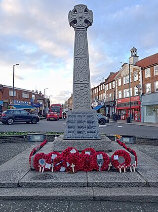
Hendon War Memorial in Hendon, North London is located on the central reservation at the junction between Watford Way and The Burroughs. It was unveiled on St George's Day, 23 April 1922, but was moved to its present location in 1962. [1] [2]
Hendon War Memorial in Hendon, North London is located on the central reservation at the junction between Watford Way and The Burroughs. It was unveiled on St George's Day, 23 April 1922, but was moved to its present location in 1962. [1] [2]
By 1906, Sir Audley Neeld was building on the land that had been Renters Farm, starting with a new road from Station Road to Queens Road, later called Vivian Avenue. The eventual estate used many names associated with the family: Dallas, Audley, Elliot, Graham, Rundell, Vivian, Algernon and Neeld. Other names are associated with Neeld estates in Grittleton, including Alderton, Foscote, Sevington, and Allington.
Hendon Central Underground station and the Watford Way were constructed in 1923. Originally, the road was planned to cut through the Neeld Estate, but in January 1924 a local ratepayers' group in Hendon Central, backed by Hendon Urban District Council, petitioned the County Council and central government, and the route was changed so that it would pass up Queen's Road (better known now as Hendon Way).

The Bakerloo line is a London Underground line that runs from Harrow & Wealdstone in suburban north-west London to Elephant & Castle in south London, via the West End. Printed in brown on the Tube map, it serves 25 stations, 15 of which are underground, over 23.2 kilometres (14.4 mi). It runs partly on the surface and partly through deep-level tube tunnels.

The Northern line is a London Underground line that runs from North London to South London. It is printed in black on the Tube map. The Northern line is unique on the Underground network in having two different routes through central London, two southern branches and two northern branches. Despite its name, it does not serve the northernmost stations on the Underground, though it does serve the southernmost station at Morden, the terminus of one of the two southern branches.
Hendon is an urban area in the London Borough of Barnet, northwest London 7 miles (11 km) northwest of Charing Cross. Hendon was an ancient manor and parish in the county of Middlesex and a former borough, the Municipal Borough of Hendon; it has been part of Greater London since 1965. Hendon falls almost entirely within the NW4 postcode, while the West Hendon part falls in NW9. Colindale to the northwest was once considered part of Hendon but is today separated by the M1 motorway.

The London Borough of Barnet is a local authority area on the northern outskirts of London. The borough was formed in 1965 from parts of the ceremonial counties of Middlesex and Hertfordshire. It is the second largest London borough by population with 389,344 inhabitants as of 2021, also making it the 17th largest district in England. The borough covers an area of 86.74 square kilometres (33 sq mi), the fourth highest of the 32 London boroughs, and has a population density of 45.8 people per hectare, which ranks it 25th.

Edgware Road is a major road in London, England. The route originated as part of Roman Watling Street and, unusually in London, it runs for 10 miles (16 km) in an almost perfectly straight line. Forming part of the modern A5 road, Edgware Road undergoes several name changes along its length, including Maida Vale, Kilburn High Road, Shoot Up Hill and Cricklewood Broadway; but the road is, as a whole, known as the Edgware Road, as it is the road to Edgware.

Watford is a town and borough in Hertfordshire, England, 15 mi (24 km) north-west of Central London, on the banks of the River Colne.

Bushey is a town in the Hertsmere borough of Hertfordshire in the East of England. It had a population of 25,328 in the 2011 census, rising to 28,416 in the 2021 census, an increase of 12.19%. This makes Bushey the second most populated town in Hertsmere. Bushey Heath is a large neighbourhood south east of Bushey on the boundary with the London Borough of Harrow reaching elevations of 165 metres (541 ft) above sea level.
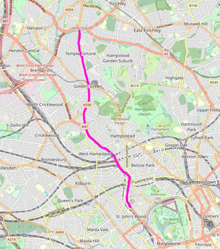
Finchley Road is a designated 4.5-mile (7-kilometre) arterial road in north-west London, England. The Finchley Road starts in St John's Wood near central London as part of the A41; its southern half is a major dual carriageway with high traffic levels often frequented by lorries and long-distance coaches as it connects central London, via the A41 Hendon Way, to the M1 motorway at Brent Cross and other roads at that interchange.
West Hendon is a district of Hendon in North London, in the London Borough of Barnet. It is the NW9 part of Hendon, located around the A5 Edgware Road and the Welsh Harp. The area is known for the West Hendon Estate which is undergoing controversial regeneration.

Cassiobury Park is the principal public park in Watford, Hertfordshire, in England. It was created in 1909 from the purchase by Watford Borough Council of part of the estate of the Earls of Essex around Cassiobury House which was subsequently demolished in 1927. It comprises over 190 acres (77 ha) and extends from the A412 Rickmansworth Road in the east to the Grand Union Canal in the west, and lies to the south of the Watford suburb of Cassiobury, which was also created from the estate. The western part is a 62-acre (25.1 ha) Local Nature Reserve managed by the Herts and Middlesex Wildlife Trust. The park hosts the free, weekly timed parkrun 5 km event every Saturday morning at 9 am, starting on the field near the Shepherds Road entrance to the park, and finishing by the bandstand.

Grittleton House is a country house in the village of Grittleton, Wiltshire, England, about 5+1⁄2 miles (9 km) northwest of the town of Chippenham. It is a building of historical significance and is Grade II* listed on the English Heritage Register.

The A4008 is a local road in south east England.

Sunny Hill Park is a park in Hendon, in the London Borough of Barnet, England. It is a large hilly park, 22 hectares, mainly grassed, which has extensive views to the north and the west. Together with the neighbouring Hendon Churchyard, it is a Site of Local Importance for Nature Conservation.
This article provides brief details of primary schools in the borough of Watford in Hertfordshire, England, United Kingdom. Some Watford children attend schools in the neighbouring boroughs of Three Rivers and Hertsmere.

Watford Borough Council is the local authority for the Watford non-metropolitan district in the south-west of Hertfordshire, England. The council is based in the Town Hall on Hempstead Road. The council comprises 36 councillors plus a directly-elected mayor.
Hendon Park is a 12 hectare London suburban park situated 7 miles (11 km) north west of Charing Cross. It borders the Northern line, and Hendon Park and Northern line Railway Cutting are a Site of Local Importance for Nature Conservation.
Sir John Neeld, 1st Baronet (1805–1891) was a member of Parliament for Cricklade between 1835 and 1859, and Chippenham, Wiltshire, England, between 1865 and 1868.
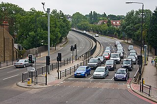
Hendon Way is one of London's busiest roads. It connects Finchley Road to Watford Way. It passes through Hampstead and Hendon, and forms part of the A41 road. (London-Birkenhead). It is a road that passes Staples Corner and meets the Watford Bypass.

Eia or Eye was an early Medieval manor in Westminster, Middlesex and is now a part of Central London. It was about one mile west of the Palace of Westminster/Whitehall, about 2 miles west-south-west of the walled City of London, and about half a mile north of the River Thames.
East Barnet War Memorial is a memorial to the dead of the First and Second World Wars from East Barnet, London. It was unveiled on 27 June 1920 and originally stood on the crossroads of East Barnet Road and Church Hill Road, but was later moved a short distance so that it now stands in front of the Brookside Methodist Church.
| | This article about a London building or structure is a stub. You can help Wikipedia by expanding it. |