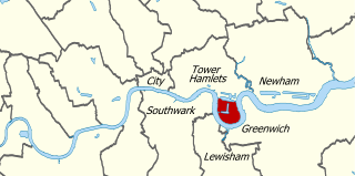
Traffic Light Tree

Last updated

Traffic Light Tree
Traffic Light Tree, Poplar.jpg
Pierre Vivant's Traffic Light Tree in its current location on the Trafalgar Way roundabout
ArtistPierre Vivant
Year1998
LocationLondon, England
Traffic Light Tree in its original location, without visible control cabinet Traffic Light Tree Canary Wharf.jpg
Traffic Light Tree in its original location, without visible control cabinet
A photograph taken with a slow shutter speed to show all of the sculpture's lights illuminated Traffic Light Tree.jpg
A photograph taken with a slow shutter speed to show all of the sculpture's lights illuminated
A video showing a 1¼-minute sequence of the lights

Traffic Light Tree is a public sculpture in between Poplar and Blackwall, London, England, created by the French sculptor Pierre Vivant following a competition run by the Public Art Commissions Agency for the London Docklands Development Corporation under their Public Art programme. Originally situated on a roundabout in Limehouse, near Canary Wharf and Millwall, at the junction of Heron Quay, Marsh Wall and Westferry Road, [1] it is now located on a different roundabout near Billingsgate Market in Poplar.

Contents

Eight metres tall and containing 75 sets of lights, each controlled by computer, the sculpture was described by Vivant thus:

The Sculpture imitates the natural landscape of the adjacent London Plane Trees, while the changing pattern of the lights reveals and reflects the never ending rhythm of the surrounding domestic, financial and commercial activities. [2]

The Public Art Commissions Agency has said "the arbitrary cycle of light changes is not supposed to mimic the seasonal rhythm of nature, but the restlessness of Canary Wharf." [3]

Traffic Light Tree was installed in 1998 on the site of a plane tree [4] that was suffering as a result of pollution. [5] It was initially intended that the lights would be triggered to reflect flurries of activity on the London Stock Exchange, but this proved to be too expensive to put into practice. [6]

Although some motorists were initially confused by the traffic lights, mistaking them for real signals, the sculpture soon became a favourite among both tourists and locals. In 2005, Saga Motor Insurance commissioned a survey asking British motorists about the best and worst roundabouts in the country. The one containing Traffic Light Tree was the clear favourite. [7]

Relocation

In December 2011, the sculpture was removed from Limehouse by the owner, Tower Hamlets Council, as part of remodelling work to the Westferry roundabout. [8] In January 2012, the council stated that the work would remain on the Isle of Dogs, but no specific location was named, [9] although it was reported in early 2013 that a planning application had been received by the council to re-install the piece on the Trafalgar Way roundabout near Billingsgate Market. [10] Re-erection was planned to begin at the Trafalgar Way roundabout on 11 November 2013 and to be completed by 11 December 2013.[ citation needed ]

There was an official lighting-up ceremony at the new location on 20 January 2014, led by Mayor of Tower Hamlets Lutfur Rahman. [11] [12]

See also

Related Research Articles

<span class="mw-page-title-main">Limehouse</span> District in Tower Hamlets, London

Limehouse is a district in the London Borough of Tower Hamlets in East London. It is 3.9 miles (6.3 km) east of Charing Cross, on the northern bank of the River Thames. Its proximity to the river has given it a strong maritime character, which it retains through its riverside public houses and steps, such as The Grapes and Limehouse Stairs. It is part of the traditional county of Middlesex. It became part of the ceremonial County of London following the passing of the Local Government Act 1888, and then part of Greater London in 1965.

<span class="mw-page-title-main">Poplar, London</span> Area of East London, England

Poplar is a district in East London, England, now part of the London Borough of Tower Hamlets. Five miles (8 km) east of Charing Cross, it is part of the East End.

<span class="mw-page-title-main">London Borough of Tower Hamlets</span> Borough in London, England

The London Borough of Tower Hamlets is a borough of London, England. Situated on the north bank of the River Thames and immediately east of the City of London, the borough spans much of the traditional East End of London and includes much of the regenerated London Docklands area. The 2019 mid-year population for the borough is estimated at 324,745.

<span class="mw-page-title-main">Canary Wharf</span> Major business and financial district in London, England

Canary Wharf is an area of East London, England, located near the Isle of Dogs in the London Borough of Tower Hamlets. Canary Wharf is defined by the Greater London Authority as being part of London's central business district, alongside Central London. Alongside the City of London, it constitutes one of the main financial centres in the United Kingdom and the world, containing many high-rise buildings including the third-tallest in the UK, One Canada Square, which opened on 26 August 1991.

<span class="mw-page-title-main">Limehouse station</span> Docklands Light Railway and National Rail station

Limehouse is a National Rail and connected Docklands Light Railway (DLR) station in Limehouse, London, England. It is served by regional services operated by c2c to and from Fenchurch Street, and by light metro services provided by the DLR to and from Tower Gateway or Bank. On the main line, Limehouse is located 1 mile 58 chains (2.8 km) from Fenchurch Street and the following station is West Ham; on the DLR it is between Shadwell and Westferry in Travelcard Zone 2.

<span class="mw-page-title-main">Westferry DLR station</span> Docklands Light Railway station

Westferry is a station on the Docklands Light Railway (DLR), at the junction of Limehouse Causeway and Westferry Road in Limehouse in London Docklands, England. The station is located in Travelcard Zone 2. To the west is Limehouse station, whilst to the east the DLR splits, with one branch going to Poplar station and the other to West India Quay station.

<span class="mw-page-title-main">Millwall</span> Area of the Isle of Dogs in London, England

Millwall is a district on the western and southern side of the Isle of Dogs, in east London, England, in the London Borough of Tower Hamlets. It lies to the immediate south of Canary Wharf and Limehouse, north of Greenwich and Deptford, east of Rotherhithe, west of Cubitt Town, and has a long shoreline along London's Tideway, part of the River Thames. It was part of the County of Middlesex and from 1889 the County of London following the passing of the Local Government Act 1888, it later became part of Greater London in 1965.

<span class="mw-page-title-main">London Docklands Development Corporation</span> English regeneration agency (1981–1998)

The London Docklands Development Corporation (LDDC) was a quango agency set up by the UK Government in 1981 to regenerate the depressed Docklands area of east London. During its seventeen-year existence, it was responsible for regenerating an area of 8.5 square miles (22 km2) in the London Boroughs of Newham, Tower Hamlets and Southwark. LDDC helped to create Canary Wharf, Surrey Quays shopping centre, London City Airport, ExCeL Exhibition Centre, London Arena and the Docklands Light Railway, bringing more than 120,000 new jobs to the Docklands and making the area highly sought after for housing. Although initially fiercely resisted by local councils and residents, today it is generally regarded as having been a success and is now used as an example of large-scale regeneration, although tensions between older and more recent residents remain.

<span class="mw-page-title-main">Limehouse Link tunnel</span> Road tunnel under Limehouse in East London

The Limehouse Link tunnel is a 1.1-mile (1.8 km) long tunnel under Limehouse in East London on the A1203 road. The tunnel links the eastern end of The Highway to Canary Wharf in London Docklands. Built between 1989 and 1993 at a cost of £293,000,000 it has been calculated as the most expensive road scheme in Britain per mile, working out at £50,500 per foot at 2011 prices. It is the second largest non-estuarial road tunnel in the UK, after the Hindhead Tunnel in Surrey.

<span class="mw-page-title-main">Narrow Street</span>

Narrow Street is a narrow road running parallel to the River Thames through the Limehouse area of east London, England. It used to be much narrower, and is the oldest part of Limehouse, with many buildings originating from the eighteenth century.

<span class="mw-page-title-main">Poplar DLR station</span> Docklands Light Railway station

Poplar is a Docklands Light Railway (DLR) station in Poplar in London, England. Poplar is a cross-platform interchange station for three of the six lines on the DLR making it one of the busiest stations on the network in terms of services. It is also nearby the Canary Wharf Station on Crossrail's Elizabeth Line.

<span class="mw-page-title-main">West India Quay DLR station</span> Docklands Light Railway station

West India Quay is a Docklands Light Railway (DLR) station in Canary Wharf’s West India Quay. It is located at the point where the line from Lewisham splits into branches to Tower Gateway/Bank and Stratford. The next stations on each line are Canary Wharf DLR station, Westferry and Poplar DLR station. The station is in Travelcard Zone 2.

<span class="mw-page-title-main">St Anne's Limehouse</span> Church

St Anne's Limehouse is a Hawksmoor Anglican Church in Limehouse, in the London Borough of Tower Hamlets. It was consecrated in 1730, one of the twelve churches built through the 1711 Act of Parliament.

<span class="mw-page-title-main">Poplar and Limehouse (UK Parliament constituency)</span> Constituency represented in the UK Parliament

Poplar and Limehouse is a constituency created in 2010 and represented in the House of Commons of the UK Parliament since 2019 by Apsana Begum of the Labour Party. From its creation until 2019, it was represented by Jim Fitzpatrick, also of Labour.

<span class="mw-page-title-main">London Buses route 277</span> London bus route

London Buses route 277 is a Transport for London contracted bus route in London, England. Running between Cubitt Town and Dalston Junction station, it is operated by Stagecoach London.

<span class="mw-page-title-main">London Buses route 135</span> London bus route

London Buses route 135 is a Transport for London contracted bus route in London, England. Running between Cubitt Town and Moorfields Eye Hospital, it is operated by Stagecoach London.

<span class="mw-page-title-main">A1206 road (Great Britain)</span> Road around the Isle of Dogs, in the east of London, England

The A1206, also known as the Isle of Dogs Distributor Road, is a crescent-shaped ring road around the Isle of Dogs, in the East End of London. It is made up of Westferry Road, Manchester Road and Prestons Road and is the main road through the area, connecting parts of the London Docklands.

<span class="mw-page-title-main">Landmark Pinnacle</span> Residential skyscraper in London

Landmark Pinnacle is a 233-metre (764 ft) skyscraper constructed by developer Chalegrove Properties in Marsh Wall on the Isle of Dogs, London, United Kingdom. The 75-storeys Landmark Pinnacle is a short distance west from the financial center of Canary Wharf. It is the tallest residential tower in the United Kingdom, the tallest residential building in western Europe and has more habitable floors than any other building in western Europe. As of 2023, Landmark Pinnacle is the fourth tallest building in the United Kingdom. The development was formerly known as City Pride, the same name as the public house it replaced, before a name change in 2016.

<span class="mw-page-title-main">Westferry Circus</span> Public space in Canary Wharf

Westferry Circus is a road interchange and public space within the Westferry Complex and is part of the Canary Wharf in London, and contains a two-level road interchange. There are two roundabouts, one above the other. It was designed by Laurie Olin. In this context, a circus, from the Latin word meaning "circle", is a round open space at a street junction.

References

  1. "The Traffic Light Tree, Pierre Vivant 1998". City Noise. 12 June 2006. Archived from the original on 18 April 2010. Retrieved 29 September 2009.
  2. Ivanov, Alexander. "London's Lesser Known". mindzgap.co.ukdate=24 March 2009. Archived from the original on 22 August 2011. Retrieved 29 September 2009.
  3. Hackett, Regina (8 September 2008). "Bladerunner, continued". Seattle P-I. Retrieved 29 September 2009.
  4. "Pierre Vivant". canarywharf.com. Archived from the original on 23 July 2008. Retrieved 29 September 2009.
  5. Sumpter, Helen (10 April 2006). "Sculpture club". Time Out. London. Retrieved 29 September 2009.
  6. "Grand Illusions: Traffic Light Tree". Archived from the original on 21 July 2009. Retrieved 29 September 2009.
  7. "Brits vote on the best and worst roundabouts". easier.com. 20 December 2005. Retrieved 29 September 2009.
  8. Virtue, Rob (8 December 2011). "Upset as Westferry Traffic Light Tree removed". Wharf. Retrieved 14 December 2011.
  9. Virtue, Rob (24 January 2012). "Traffic Light Tree will return to the Isle of Dogs". Wharf. Retrieved 25 January 2012.
  10. Brook, Mike (14 January 2013). "Iconic Traffic Light tree to shine a light on Canary Wharf again". East London Advertiser. Retrieved 10 November 2013.
  11. Thienel, Gloria R. (18 January 2014). "Lighting Up" (email).
  12. Virtue, Rob (21 January 2014). "Canary Wharf's Traffic Light Tree switched on". Wharf. Retrieved 22 January 2014.

51°30′25″N0°00′38″W / 51.50684°N 0.01055°W / 51.50684; -0.01055

Commons-logo.svg Media related to Traffic Light Tree at Wikimedia Commons