Walworth is a district of south London, England, within the London Borough of Southwark. It adjoins Camberwell to the south and Elephant and Castle to the north, and is 1.9 miles (3.1 km) south-east of Charing Cross.

The London Borough of Bexley is a London borough in south-east London, forming part of Outer London. It has a population of 248,287. The main settlements are Sidcup, Erith, Bexleyheath, Crayford, Welling and Old Bexley. The London Borough of Bexley is within the Thames Gateway, an area designated as a national priority for urban regeneration. The local authority is Bexley London Borough Council.

Medway is a unitary authority district and conurbation in Kent, South East England. It had a population of 278,016 in 2019. The unitary authority was formed in 1998 when Rochester-upon-Medway amalgamated with the Borough of Gillingham to form Medway Towns. It is now a unitary authority area run by Medway Council, independent of Kent County Council but still part of the ceremonial county of Kent.

The Borough of Dartford is a local government district in the north-west of the county of Kent, England. Its council is based in the town of Dartford. It is part of the contiguous London urban area. It borders the borough of Gravesham to the east, Sevenoaks District to the south, the London Borough of Bexley to the west, and the Thurrock unitary authority in Essex to the north, across the River Thames. The borough was formed on 1 April 1974 by the merger of the Municipal Borough of Dartford, the Swanscombe Urban District, and part of the Dartford Rural District. According to the 2011 Census, its population was 97,365.

Ashford is a town in the county of Kent, England. It lies on the River Great Stour at the southern or scarp edge of the North Downs, about 61 miles (98 km) southeast of central London and 15.3 miles (24.6 km) northwest of Folkestone by road. At the 2021 census, it had a population of 76,405. The name comes from the Old English æscet, indicating a ford near a clump of ash trees. It has been a market town since the Middle Ages, and a regular market continues to be held.

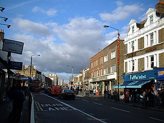
Old Kent Road is a major thoroughfare in South East London, England, passing through the London Borough of Southwark. It was originally part of an ancient trackway that was paved by the Romans and used by the Anglo-Saxons who named it Wæcelinga Stræt. It is now part of the A2, a major road from London to Dover. The road was important in Roman times linking London to the coast at Richborough and Dover via Canterbury. It was a route for pilgrims in the Middle Ages as portrayed in Chaucer's Canterbury Tales, when Old Kent Road was known as Kent Street. The route was used by soldiers returning from the Battle of Agincourt.
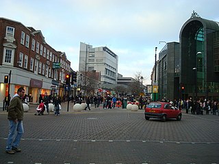
Bromley is a large town in Greater London, England, within the London Borough of Bromley. It is 9.4 miles (15.1 km) south-east of Charing Cross, and had an estimated population of 87,889 as of 2011.

Rainham is a town in the unitary authority of Medway, in Kent, South East England. The town forms a conurbation with neighbouring towns Chatham, Rochester, Strood and Gillingham.

Strood is a town in the unitary authority of Medway in Kent, South East England. The town forms a conurbation with neighbouring towns Chatham, Rochester, Gillingham and Rainham. It lies on the northwest bank of the River Medway at its lowest bridging point.

Hendon was an ancient civil parish of around 8,250 acres (33 km2) which included Mill Hill on the border of Hertfordshire, as well as Golders Green and Childs Hill on the border of what became the County of London. In 1894 it was created an urban district of Middlesex and in 1932 it became a municipal borough. The municipal borough was abolished in 1965 and the area became part of the London Borough of Barnet.

Newport Civic Centre is a municipal building in Godfrey Road in Newport, South Wales. The civic centre, which is the headquarters of Newport City Council, is a Grade II* Listed building.
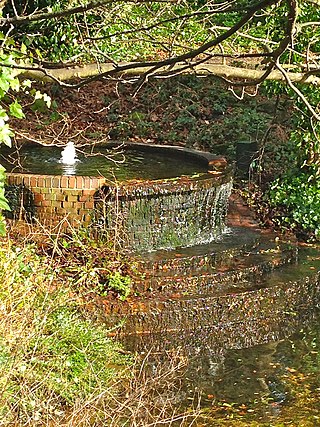
St Blaise's Well is a holy well located in the grounds of the old Bishop's Palace, now part of Bromley Civic Centre in Bromley, London.

Adam Kossowski was a Polish artist, born in Nowy Sącz, notable for his works for the Catholic Church in England, where he arrived in 1943 as a refugee from Soviet labour camps and was invited in 1944 to join the Guild of Catholic Artists and Craftsmen.

The Brixton murals are a series of murals by local artists in the Brixton area, in south London. Most of the murals were funded by Lambeth London Borough Council and the Greater London Council after the Brixton riots in 1981.

Henry Varnum Poor was an American architect, painter, sculptor, muralist, and potter. He was a grandnephew of the Henry Varnum Poor who was a founder of the predecessor firm to Standard & Poor's.
Salford Civic Centre, formerly Swinton and Pendlebury Town Hall, is a municipal building at Chorley Road, in Swinton, Greater Manchester, England. It is the administrative headquarters of Salford City Council.
William George Mitchell was an English sculptor, artist and designer. He is best known for his large scale concrete murals and public works of art from the 1960s and 1970s. His work is often of an abstract or stylised nature with its roots in the traditions of craft and "buildability". His use of heavily modelled surfaces created a distinctive language for his predominantly concrete and glass reinforced concrete (GRC) sculptures. After long years of neglect, many of William Mitchell's remaining works in the United Kingdom are now being recognised for their artistic merit and contemporary historic value, and have been granted protective, listed status.

Gary Drostle is a British artist specialising in public art, sculpture and mosaic as well as mural painting and drawing. He was also President of the British Association for Modern Mosaic, a lecturer at The Chicago Mosaic School. and is on the editorial board of Andamento the Journal of Contemporary Mosaics.

Harrow Civic Centre is a municipal building in Station Road, Harrow, London. It is the headquarters of Harrow London Borough Council.

St Botolph's Church is a church building in Ruxley, in the London Borough of Bromley, southest London, England. It was constructed in the thirteenth century and dedicted to Botwulf of Thorney. St Botolph's was used as a church for around 300 years but was deconsecrated in 1557. The church was then used a farm building for over 400 years and the remains of an oast house are still adjacent to it. In the 1960s archaeological work was carried out on the site and found evidence of an older wooden building, suggesting there may have been an older Saxon church in the same location. Today the church is a Grade II listed building and a scheduled ancient monument on the grounds of Ruxley Manor Garden Centre, although many features are still intact, the church is in disrepair and English Heritage have agreed to pay a grant to help preserve the building.

