This is a list of public art in the London Borough of Hounslow .
This is a list of public art in the London Borough of Hounslow .
| Image | Title / subject | Location and coordinates | Date | Artist / designer | Type | Designation | Notes |
|---|---|---|---|---|---|---|---|
 | Topiary | Church of St Mary the Virgin 51°27′5.46″N0°26′24.73″W / 51.4515167°N 0.4402028°W | 1704 | Topiary | — | ||
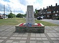 | Bedfont War Memorial | Grovestile Way, East Bedfont 51°27′5.54″N0°26′7.24″W / 51.4515389°N 0.4353444°W | Pillar | — | [1] | ||
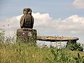 | Wooden owl sculpture on bench | Bedfont Lakes Country Park | Sculpture | — |
| Image | Title / subject | Location and coordinates | Date | Artist / designer | Type | Designation | Notes |
|---|---|---|---|---|---|---|---|
 | Lion Gate | Syon House, London Road 51°28′47″N0°19′08″W / 51.47981°N 0.31901°W | 18th century | Robert Adam | Statue | Grade I on 15 June 1951 | [2] [3] |
 | Coat of arms of Middlesex | On Kew Bridge (see also under Richmond upon Thames) 51°29′13″N0°17′14″W / 51.48708°N 0.28735°W | 1903 | John Wolfe Barry and Cuthbert A. Brereton | Relief | Grade II on 11 February 1988 | [4] |
| Coat of arms of Middlesex | Floor of entrance hall of Brentford Library | 1904 | Nowell Parr | Mosaic | Grade II on 2 October 1990 | ||
 | Boer War Memorial | In Brentford Library, on staircase | 1904 | Nowell Parr | Plaque | Grade II on 2 October 1990 | [5] |
 More images | Brentford Monument Battles of Brentford in 54 BC, 1016 and 1642 | Brentford High Street, at junction of Alexandra Road and outside Brentford County Court 51°29′03″N0°18′14″W / 51.48412°N 0.30401°W | 1909 (originally stood in Ferry Lane; moved to current site 1992) | Pillar | — | [6] | |
 More images | Brentford War Memorials | Near junction of Boston Manor Road and Windmill Road, outside Brentford Library 51°29′12″N0°18′28″W / 51.48662°N 0.30781°W | 1923 (main memorial); the smaller memorials were installed in 1949 and 2009 | ? | Square column (main memorial) | — | [7] |
 | Inspiration to Flight | Wallis House, formerly Smithkline Beecham House, Great West Road, originally built as a factory for Simmonds Aerocessaries | 1940 | Donald Gilbert | Architectural sculpture | Grade II on 25 January 1991 | [8] |
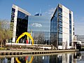
 More images | The Bargemaster | In front of EMC2 51°29′33.67″N0°17′23.1″W / 51.4926861°N 0.289750°W | 1990 | Diana Thomson | Statue | — | [9] [10] [11] |
 | Acrobat | GlaxoSmithKline building 51°29′14.43″N0°19′6.92″W / 51.4873417°N 0.3185889°W | 2001 | Allen Jones | Sculpture | — | [12] |
 More images | Liquidity | Ferry Wharf, at the entrance to the Grand Union Canal from the River Thames 51°28′59.94″N0°17′58.86″W / 51.4833167°N 0.2996833°W | 2002 | Simon Packard | Sculpture | — | [13] |
| Totem | Ferry Quays marina | Simon Packard | Sculpture | — | [13] |
| Image | Title / subject | Location and coordinates | Date | Artist / designer | Type | Designation | Notes |
|---|---|---|---|---|---|---|---|
 More images | Statue of Andrea Palladio | Chiswick House 51°29′00.8″N0°15′30.9″W / 51.483556°N 0.258583°W | c. 1730 | John Michael Rysbrack | Statue | Grade I on 21 May 1973 | [14] |
 | Statue of Inigo Jones | Chiswick House | c. 1730 | John Michael Rysbrack | Statue | Grade I on 21 May 1973 | [14] |
 | Venus (replacement for a previous copy) | Chiswick House grounds 51°29′06.9″N0°15′33.7″W / 51.485250°N 0.259361°W | Statue | Not listed, but the column on which it stands is | |||
 | Group of statues and ornaments | Chiswick House grounds 51°29′04.2″N0°15′35.6″W / 51.484500°N 0.259889°W | Sculpture | Grade I on 21 May 1973 | |||
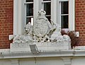 | Royal coat of arms | 210 Chiswick High Road, formerly Chiswick Police Station (until 1972); now converted to a restaurant | 1872 | ? | Architectural sculpture | — | [15] |
 | Ellen Reardon Drinking Fountain Daniel, Elizabeth and Margaret Reardon | Strand-on-the-Green 51°29′01″N0°16′38″W / 51.48364°N 0.27718°W | 1880 | ? | Drinking fountain | — | |
 More images | Bedford Park War Memorial | Bedford Park, near St Michael and All Angels church 51°29′46.22″N0°15′18.69″W / 51.4961722°N 0.2551917°W | 1919–1920 | Inigo Triggs | Seat | Grade II on 7 January 2015 | [16] |
 More images | Chiswick War Memorial | Turnham Green 51°29′32″N0°15′48″W / 51.49229°N 0.26332°W | 1921 | Edward Willis | Obelisk | Grade II on 31 March 2015 | [17] |
 | Couplet | Corner of Church Street and Chiswick Mall 51°29′09″N0°15′0″W / 51.48583°N 0.25000°W | 1999 | Charles Hadcock | Sculpture | — | [18] |
 More images | Statue of William Hogarth and his dog Trump | Chiswick High Road 51°29′33″N0°15′19″W / 51.49259°N 0.25518°W | 2001 | Jim Mathieson | Statue | — | Unveiled by Ian Hislop and David Hockney. [19] |
| Mosaics | Belmont Primary School 51°29′35.41″N0°15′48.25″W / 51.4931694°N 0.2634028°W | 2004 | Sue Edkins and schoolchildren | Mosaics | — | [20] | |
 | V2 Attack Victims Memorial | Staveley Road 51°28′55.95″N0°15′51.31″W / 51.4822083°N 0.2642528°W | 2004 | ? | Stone of remembrance | — | Unveiled 8 September 2004. [21] |
 | Large Concretised Monument to the Twentieth Century | Chiswick Business Park 51°29′45″N0°16′32″W / 51.4959°N 0.2756°W | 2007 | Rebecca Warren | Sculpture | — | [22] |
| Two-Way Mirror Labyrinth | Chiswick Business Park 51°29′41″N0°16′30″W / 51.4947°N 0.2749°W | 2007 | Jeppe Hein | Sculpture | — | [23] | |
| Cormorant | Chiswick Business Park 51°29′41″N0°16′30″W / 51.4947°N 0.2749°W | 2009 | Kevin Herlihy | Sculpture | — | Made with recycled rubbish from the Thames [24] | |
| Chiswick Timeline: A History in Art and Maps | Under railway bridge near Turnham Green tube station | 2017–2018 | Abundance London (Sarah Cruz, Karen Liebreich and Karen Wyatt) with Peter Blake and Jan Pieńkowski | Mural on vitreous enamel panels | — | Unveiled 28 January 2018. [25] | |
| Drinking fountain | At entrance to Chiswick Back Common, Turnham Green Terrace, Chiswick | ? | ? | Drinking fountain | — |
| Image | Title / subject | Location and coordinates | Date | Artist / designer | Type | Designation | Notes |
|---|---|---|---|---|---|---|---|
 | Old Minimax factory gateway | Minimax Corner (junction of Staines Road and Fagg's Road) 51°27′27.6″N0°24′36.8″W / 51.457667°N 0.410222°W | 1911 | Architectural fragment | — | ||
 More images | Feltham War Memorial | High Street, near pond 51°26′41.18″N0°24′38.4″W / 51.4447722°N 0.410667°W | c. 1920 | ? | Cenotaph | Grade II on 19 July 2018 | [26] |
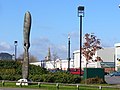 | Propeller sculpture | London Air Park / Browell's Lane roundabout. Located on the former site of the General Aircraft Ltd factory 51°26′34″N0°24′15.96″W / 51.44278°N 0.4044333°W | 1997 | William Peers | Sculpture | — | |
| Madam Alaska and her lion | Alf King Children's Centre 51°26′53.35″N0°24′24.99″W / 51.4481528°N 0.4069417°W | 2011 | Feltham Arts Association, Susie John and Gemma Hutton | Mural | — | [27] | |
| Four Seasons | The Centre 51°26′46.27″N0°24′37.4″W / 51.4461861°N 0.410389°W | 2014 | 400 people from Feltham, Bedfont and Hanworth | Mosaics | — | [28] | |
| Rugby mural | Feltham RFC, Hanworth Park | ? | ? | Mural | — | [29] | |
| Graffiti gallery | Feltham Circles, Pevensey Road Nature Reserve 51°26′51.88″N0°23′24.01″W / 51.4477444°N 0.3900028°W | ? | ? | Street art | — | [30] |
| Image | Title / subject | Location and coordinates | Date | Artist / designer | Type | Designation | Notes |
|---|---|---|---|---|---|---|---|
 More images | Hanworth War Memorial | Junction of Main Street and Green Lane 51°25′47.13″N0°23′24.73″W / 51.4297583°N 0.3902028°W | 1920 | A. P. Green (architect); Keates & Co. (builders) | Celtic cross | Grade II on 7 March 2018 | [31] |
 | Cow sculptures | Roof of Job's Dairy 51°25′47.27″N0°24′12″W / 51.4297972°N 0.40333°W | 1977 | Volunteers | Architectural sculpture | — | [32] |
| Several murals | The Hanworth Centre, 66 Hounslow Road 51°26′11.31″N0°23′28.46″W / 51.4364750°N 0.3912389°W | ? | ? | Murals | — | [33] [34] | |
| 60 ft mural to fallen soldiers | Hanworth Royal British Legion Club garden 51°26′2.62″N0°23′15.67″W / 51.4340611°N 0.3876861°W | ? | ? | Mural | — | [35] [36] |
| Image | Title / subject | Location and coordinates | Date | Artist / designer | Type | Designation | Notes |
|---|---|---|---|---|---|---|---|
 | Brentford drinking fountain | New Western International Market, Hayes Road, Southall 51°29′51.65″N0°24′24.65″W / 51.4976806°N 0.4068472°W | 1877 at Kew Bridge, moved in 1974 | ? | Drinking fountain | Grade II on 29 April 2003 | [37] |
 More images | Heston War Memorial | Near St Leonard's Church, Heston Road 51°29′07″N0°22′24″W / 51.485395°N 0.373429°W | 1918 | Arthur George Walker | Statue | Grade II on 19 April 2001 | [38] |
| The Ramblers | Heston Farm Estate, near the M4 motorway 51°29′21.4″N0°21′55.19″W / 51.489278°N 0.3653306°W | 2001 | Ray Smith | Sculpture | — | [39] [40] |
| Image | Title / subject | Location and coordinates | Date | Artist / designer | Type | Designation | Notes |
|---|---|---|---|---|---|---|---|
 | Angels | Holy Trinity Church, High Street 51°28′6.42″N0°21′51.72″W / 51.4684500°N 0.3643667°W | 1961–1965 | Wilfred Dudeney | Architectural sculpture | — | [41] |
 | Heart of Space | Lampton Park, relocated from Hounslow Civic Centre 51°28′28.77″N0°22′5.82″W / 51.4746583°N 0.3682833°W | 1980 | Charles Hewlings | Sculpture | — | [42] |
 | Gate, archway and fence panels | Beaversfield Park / Ravensdale Road / Rosemary Avenue 51°28′12.22″N0°23′12.21″W / 51.4700611°N 0.3867250°W | 2005/2006 | Chris Plowman | — | [43] | |
| Smile | Side of Platform 3 pub (formerly North Star), Whitton Road 51°27′45.71″N0°21′46.06″W / 51.4626972°N 0.3627944°W | 2007 | Propapropaganda / Banksy | Street art | — | [30] [44] | |
 | Community mosaics | North of High Street, on edge of car park 51°28′9.96″N0°21′42.72″W / 51.4694333°N 0.3618667°W | Unveiled 30 March 2012 | School and community groups under Susie John and Sue Edkins. | Mosaics | — | |
 | Hounslow War Memorial | Holy Trinity Church, High Street | Unveiled 2 August 2014 | — | [45] | ||
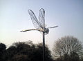 | Dragonfly | Hounslow Heath, near the Staines Road/Frampton Road car park 51°27′44.0″N0°23′16.8″W / 51.462222°N 0.388000°W | — | ||||
| Memorial to the first flight from Britain to Australia | Staines Road, near Hounslow Heath 51°27′46.9″N0°23′14.8″W / 51.463028°N 0.387444°W | — | [46] | ||||
| Mural | Tivoli Road 51°27′50.4″N0°23′8.75″W / 51.464000°N 0.3857639°W | Paint My Panda | — | [47] |
| Image | Title / subject | Location and coordinates | Date | Artist / designer | Type | Designation | Notes |
|---|---|---|---|---|---|---|---|
 | Four cast iron lamp standards | Main entrance to former Gillette Factory, Syon Lane (Gillette Corner) 51°29′2.31″N0°19′37.96″W / 51.4839750°N 0.3272111°W | 19th century | ? | Lamp standards with sculpture | Grade II on 21 May 1973 | |
 | Glossop Memorial Henry Glossop | Upper Square 51°28′7.26″N0°19′29.43″W / 51.4686833°N 0.3248417°W | 1870 | ? | Drinking fountain with lamp standard | — | Commemorates the Reverend Henry Glossop (1780–1869), the vicar of All Saints' Church. [48] [49] |
 More images | Isleworth War Memorial | Twickenham Road, in front of St Bridget's Roman Catholic Church 51°28′09.32″N0°19′43.04″W / 51.4692556°N 0.3286222°W | 1922 | A. P. Green (architect); Keates and Co. (builders) | Clock tower | Grade II on 3 July 2000 | Unveiled 22 June 1922. [50] |
 | Borough Road College War Memorial | Borough Road | After 1918 | ? | Celtic cross | — | [51] |
| Butterflies and birds | Entrance to Redlees Park, Twickenham Road 51°27′53.02″N0°19′52.04″W / 51.4647278°N 0.3311222°W | 1990s | ? | Motifs on railings | — | [52] | |
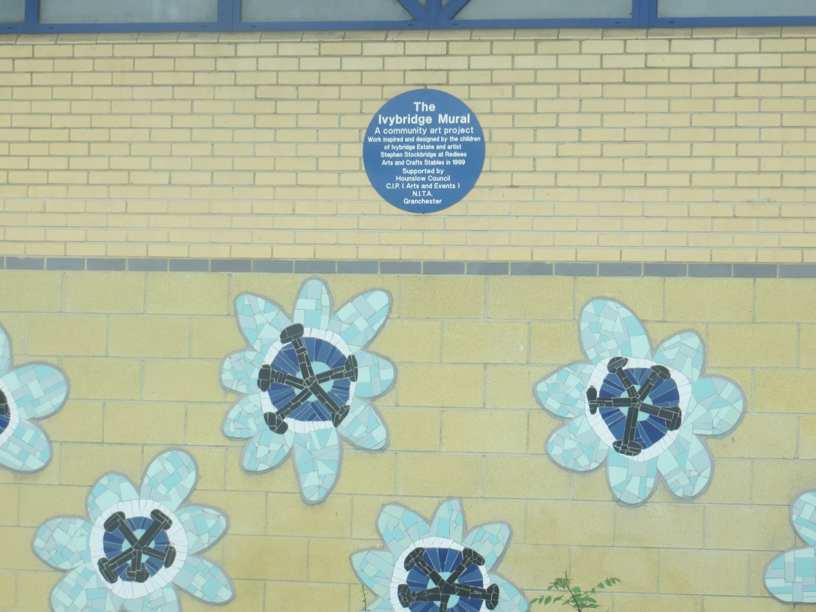
| The Ivybridge Mural | Mogden Lane, Ivybridge estate 51°27′37.31″N0°19′57.04″W / 51.4603639°N 0.3325111°W | 1999 | Stephen Stockbridge | Mural | — | [53] | |
 | The Heron | The Cathja Dutch barge, moored at Old Isleworth | ? | Martin Cotts | Sculpture | — | [54] |
| Rooster and Fox | West Middlesex University Hospital | ? | Patrick Moya | Sculpture | — | [55] |
| Image | Title / subject | Location and coordinates | Date | Artist / designer | Type | Designation | Notes |
|---|---|---|---|---|---|---|---|
 | Eagles with crowns round necks | Entrance to Osterley Park House 51°29′23.02″N0°21′6.52″W / 51.4897278°N 0.3518111°W | c. 1761 | Robert Adam | Architectural sculpture | Grade I on 21 May 1973 | [56] |
| | Reliefs of mythological creatures | Portico over entrance to Osterley Park House 51°29′22.4″N0°21′5.82″W / 51.489556°N 0.3516167°W | 1760s | Robert Adam | Architectural sculpture | Grade I on 21 May 1973 | [56] |

