Hounslow is a large suburban district of West London, England, 10+3⁄4 miles west-southwest of Charing Cross. It is the administrative centre of the London Borough of Hounslow, and is identified in the London Plan as one of the 12 metropolitan centres in Greater London.

Brentford is a suburban town in West London, England and part of the London Borough of Hounslow. It lies at the confluence of the River Brent and the Thames, 8 miles (13 km) west of Charing Cross.

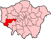
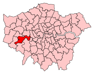
The London Borough of Hounslow is a London borough in West London, England, forming part of Outer London. It was created in 1965 when three smaller borough councils amalgamated under the London Government Act 1963. It is governed by Hounslow London Borough Council.

Isleworth is a suburban town located within the London Borough of Hounslow in West London, England. It lies immediately east of the town of Hounslow and west of the River Thames and its tributary the River Crane. Isleworth's original area of settlement, alongside the Thames, is known as 'Old Isleworth'. The north-west corner of the town, bordering on Osterley to the north and Lampton to the west, is known as 'Spring Grove'.

Osterley is an affluent district of the historic parish of Isleworth in west London approximately 8.7 miles (14.0 km) from Charing Cross and is part of the London Borough of Hounslow. Most of its land use is mixed agricultural and aesthetic parkland at Osterley House, charity-run, much of which is open to paying visitor access.

Barnes railway station is a Grade II listed station in the London Borough of Richmond upon Thames, in southwest London, and is in Travelcard Zone 3. It is 7 miles 7 chains (11.4 km) down the line from London Waterloo. The station and all trains serving it are operated by South Western Railway.

Hounslow railway station, on the Hounslow Loop Line, is in the London Borough of Hounslow, in Greater London, and is in Travelcard Zone 5. The station and all trains serving it are operated by South Western Railway.

Isleworth railway station is in the London Borough of Hounslow, in west London, and is in Travelcard Zone 4. It is 19 km (12 mi) west-southwest of London Waterloo. The unmanned station and all trains serving it are operated by South Western Railway.
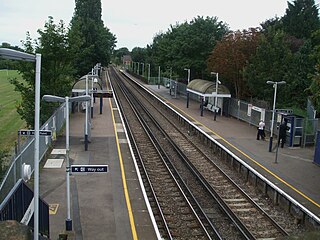
Syon Lane railway station in Travelcard Zone 4 is on the Hounslow Loop Line and borders the Spring Grove and New Brentford neighbourhoods of the London Borough of Hounslow in west London. The office and light industrial zone to the north-east, the West Cross Centre, has among other businesses the headquarters and studios of broadcaster and entertainment multinational company Sky. The station and all trains serving it are operated by South Western Railway.
Brentford and Isleworth is a constituency represented in the House of Commons of the UK Parliament. It forms the eastern part of the London Borough of Hounslow. Since 2015, it has been represented by Ruth Cadbury of the Labour Party.

The River Crane, a tributary of the River Thames, runs 8.5 miles (13.6 km) in West London, England. It forms the lower course of Yeading Brook. It adjoins or passes through three London boroughs: Hillingdon, Hounslow and Richmond upon Thames, in the historic county of Middlesex. The drainage basin is heavily urbanised but many of the Hayes to Whitton flood-meadows have been conserved, forming a narrow, green vale, opening out to what remains of Hounslow Heath in the centre – a near-continuous belt of semi-natural habitat.

The London Borough of Hounslow is a peripheral London borough in the south-west of the conurbation; as such part of the Metropolitan Green Belt lies within its boundaries. It has one of London's largest Nature reserves as well as many smaller gardens and sports grounds. The major areas are:

Heston and Isleworth was a local government district of Middlesex, England from 1894 to 1965.
Brentford and Chiswick was a constituency 1918 – 1974 centred on the Brentford and Chiswick districts of Middlesex which became parts of west London in 1965. It returned one member (MP) to the House of Commons of the UK Parliament.

Heston and Isleworth was a constituency between 1945 and 1974 for the House of Commons of the UK Parliament. It contained Heston, Hounslow, Isleworth and Osterley in Middlesex which became parts of outer west London in 1965.
Gillette Corner is a crossroads in west London. It is where a straightened medieval route Syon Lane (B454) crosses the triple carriageway of the Great West Road A4 and is the western end of the West Cross business district. A disused name for the neighbourhood is Syon Hill.


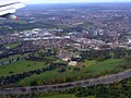 Brentford End from the air, with Syon Park in the foreground
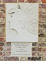 Plaque commemorating Pocahontas, who lived opposite the grounds of Syon House
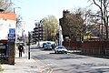 Looking towards Brentford Bridge, with former railway viaduct to the left
 Gillette Building, Golden Mile (Brentford)
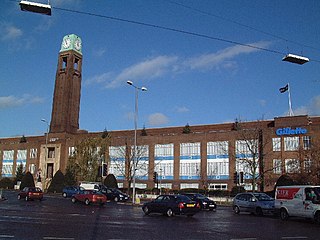