
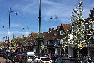
Hounslow is a large suburban district of West London, England, 10+3⁄4 miles west-southwest of Charing Cross. It is the administrative centre of the London Borough of Hounslow, and is identified in the London Plan as one of the 14 metropolitan centres in Greater London.

The London Borough of Hounslow is a London borough in west London, England, forming part of Outer London. It is governed by Hounslow London Borough Council.

Isleworth is a suburban town located within the London Borough of Hounslow in West London, England. It lies immediately east of the town of Hounslow and west of the River Thames and its tributary the River Crane. Isleworth's original area of settlement, alongside the Thames, is known as 'Old Isleworth'. The north-west corner of the town, bordering on Osterley to the north and Lampton to the west, is known as 'Spring Grove'.

Osterley is an affluent district of the historic parish of Isleworth in west London approximately 8.7 miles (14.0 km) from Charing Cross and is part of the London Borough of Hounslow. Most of its land use is mixed agricultural and aesthetic parkland at Osterley House, charity-run, much of which is open to paying visitor access.

Twickenham is a suburban district in London, England. It is situated on the River Thames 9.9 miles (15.9 km) southwest of Charing Cross. Historically part of Middlesex, it has formed part of the London Borough of Richmond upon Thames since 1965, and the borough council's administrative headquarters are located in the area.

St Margarets is an affluent suburb and neighbourhood in the London Borough of Richmond upon Thames, about 9 miles (14 km) west-southwest of central London. It is bounded by the Thames Tideway to the north-east, and the River Crane to the north-west and north where the land tapers between those rivers. Land and buildings closer to Richmond Bridge than the eponymous railway station are, traditionally distinctly, known as East Twickenham. Both places go by their post town and traditional parish, Twickenham quite often; in the 19th century the south of St Margarets was marked on maps as Twickenham Park.
Whitton is an area of the London Borough of Richmond upon Thames, England. Historically, it was the north-western part of Twickenham manor, bounded by the River Crane and the Duke of Northumberland's River.

The River Crane, a tributary of the River Thames, runs 8.5 miles (13.6 km) in West London, England. It forms the lower course of Yeading Brook. It adjoins or passes through three London boroughs: Hillingdon, Hounslow and Richmond upon Thames, in the historic county of Middlesex. The drainage basin is heavily urbanised but many of the Hayes to Whitton flood-meadows have been conserved, forming a narrow, green vale, opening out to what remains of Hounslow Heath in the centre – a near-continuous belt of semi-natural habitat.
Staines was a local government district from 1894 to 1974 named after the English town of Staines.

Heston and Isleworth was a local government district of Middlesex, England from 1875 to 1965.

The Duke of Northumberland's River or D. O. N. River consists of separate upper and lower artificial watercourses in west London, United Kingdom. The older name Isleworth Mill Stream/River more accurately describes the economic motivation behind its construction. The first section draws water via a sluice from the Colne — a source river which has seven distributaries, many of which are man-made — today an extended distance of about 5 miles (8 km) into the Crane; its lower section of about 1.8 miles (2.9 km) draws water from that small river in Whitton, Twickenham and discharges it via neighbouring Isleworth, passing Mill Plat into the tidal Thames. A sluice underneath Mill Plat feeds the main lake in Syon Park.

Heston and Isleworth was a constituency between 1945 and 1974 for the House of Commons of the UK Parliament. It contained Heston, Hounslow, Isleworth and Osterley in Middlesex which became parts of outer west London in 1965.

Isleworth Hundred was a subdivision of the historic county of Middlesex, England. In Domesday Book (1086) it was recorded as Hundeslaw Hundred.

Fulwell is a neighbourhood of outer South West London in the London Borough of Richmond upon Thames. It straddles the west of the "ancient" parish and urban district borders of Twickenham and Teddington. The name is first known in documents of the fifteenth century. It may be from a reliably full well or a corruption of foul well. Until 1965, Fulwell was in the historic County of Middlesex.

Isleworth Ait, also known as Isleworth Eyot, is a between 3.5-hectare (8.6-acre) and 9.370-acre (3.792 ha) teardrop-shaped island in the River Thames in England. The long ait is on the Tideway facing Old Isleworth and the towpath alongside the Royal Mid-Surrey Golf Club. These places are in the London Boroughs of Hounslow and Richmond upon Thames. The island faces Heron's Place and a number of commercial buildings.

The Pinn is a suburban, outer west London river. It has dendritic headwaters, the furthest is considered its source – in Harrow Weald. Its confluence with Frays River makes it a tributary of the Colne. It is one of three principal rivers wholly in the historic county of Middlesex.

Mogden Sewage Treatment Works is a sewage treatment plant in the Ivybridge section of Isleworth, West London, formerly known as Mogden. Built in 1931–36 by Middlesex County Council and now operated by Thames Water, it is the third largest sewage works in the United Kingdom. It treats the waste water from about 1.9 million people served by three main sewers serving more than the northwest quarter of Outer London and two further main sewers from the south and south-west. The plant has been extended and is constantly being upgraded with new process, most recently in OfWat Amp6 by the Costain Atkins Joint venture who delivered 6MW of Combined Heat and Power (CHP) generation, New process air blowers for Batteries A & B and six gravity sludge thickening streams. The site covers 55 hectares.

The Normansfield Theatre is a Victorian era building in Teddington, England.

Teddington was a local government district in west Middlesex around the village of Teddington from 1894 to 1937.
The South Middlesex Hospital was a hospital in Isleworth, London. Opened by the Duke of Cambridge as the Mogden Isolation Hospital in July 1898, it served its own borough and that of Richmond, retaining its name until 1938 when it was then renamed South Middlesex Fever Hospital but continued under local authority control.
