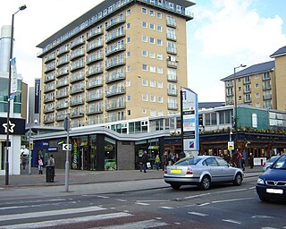
Hounslow is a large suburban district of West London, England, 10+3⁄4 miles west-southwest of Charing Cross. It is the administrative centre of the London Borough of Hounslow, and is identified in the London Plan as one of the 14 metropolitan centres in Greater London.

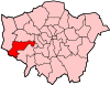
The London Borough of Hounslow is a London borough in west London, England, forming part of Outer London. It is governed by Hounslow London Borough Council.
Feltham is a town in West London, England, 13 miles (21 km) from Charing Cross. Historically part of Middlesex, it became part of the London Borough of Hounslow in 1965. The parliamentary constituency of Feltham and Heston has been held by Labour Party MPs since 1992. In 2011, the population of the combined census area of Feltham, Bedfont and Hanworth was 63,368.

Harlington is a district of Hayes in the London Borough of Hillingdon and one of five historic parishes partly developed into London Heathrow Airport and associated businesses, the one most heavily developed being Harmondsworth. It is centred 13.6 miles (21.9 km) west of Charing Cross. The district adjoins Hayes to the north and shares a railway station with the larger district, which is its post town, on the Great Western Main Line. It is in the west of the county of Greater London and until 1965 it was in the south-west corner of the historic county of Middlesex.
The London Borough of Hillingdon is a London borough in Greater London, England. It forms part of outer London and West London, being the westernmost London borough. It was formed in 1965 from the districts of Hayes and Harlington, Ruislip-Northwood, Uxbridge, and Yiewsley and West Drayton. The borough includes most of Heathrow Airport and Brunel University, and is the second largest of the 32 London boroughs by area.
Hayes is a town in west London. Historically situated within the county of Middlesex, it is now part of the London Borough of Hillingdon. The town's population, including its localities Hayes End, Harlington and Yeading, was recorded in the 2021 census as 93,928. It is situated 13 miles (21 km) west of Charing Cross, or 6.5 miles (10.5 km) east of Slough. Hayes is served by the Great Western Main Line, and Hayes & Harlington railway station is on the Elizabeth line. The Grand Union Canal flows through the town centre.

Longford is a suburban village in the London borough of Hillingdon, England. It is immediately northwest of London Heathrow Airport, which is in the same borough. It is the westernmost settlement in Greater London, very close to the borders of both Berkshire and Surrey.

Hayes and Harlington is a constituency in the west of London represented in the House of Commons of the UK Parliament since 1997 by John McDonnell of the Labour Party, who also served as the Shadow Chancellor of the Exchequer from 2015 to 2020 until his suspension and whip withdrawn on 23 July 2024, as a result of voting to scrap the two child benefit cap. He now sits as an Independent MP until the whip is re-established.

The River Crane, a tributary of the River Thames, runs 8.5 miles (13.6 km) in West London, England. It forms the lower course of Yeading Brook. It adjoins or passes through three London boroughs: Hillingdon, Hounslow and Richmond upon Thames, in the historic county of Middlesex. The drainage basin is heavily urbanised but many of the Hayes to Whitton flood-meadows have been conserved, forming a narrow, green vale, opening out to what remains of Hounslow Heath in the centre – a near-continuous belt of semi-natural habitat.
Hatton including Hatton Cross is a small settlement and locality in the London boroughs of Hillingdon and Hounslow, on the south-eastern edge of London Heathrow Airport and straddling the A30 road. Prior to 1965 it was in the county of Middlesex.
Cranford is a suburban area straddling the London Boroughs of Hillingdon and Hounslow. It is located 12.5 miles (20 km) west of Charing Cross and immediately east of Heathrow Airport, from which it is separated by the River Crane. A village till the mid-20th century, Cranford was developed with the building of major roads in its area.

Elthorne was a hundred of the historic county of Middlesex, England.

Heston and Isleworth was a local government district of Middlesex, England from 1875 to 1965.

Hayes and Harlington was a local government, urban district in west Middlesex, England from 1904 to 1965.

The A312 is an A road in England, running across west London from Hampton to Harrow. Its status varies from a local urban street to a major dual carriageway in Hayes. Part the road has been diverted to make way for Heathrow Airport, while another stretch was originally planned to be Ringway 3, one of four major ring motorways around London.

The Pinn is a suburban, outer west London river. It has dendritic headwaters, the furthest is considered its source – in Harrow Weald. Its confluence with Frays River makes it a tributary of the Colne. It is one of three principal rivers wholly in the historic county of Middlesex.

Lake Farm Country Park is an expanse of green belt land approximately 60 acres in size fringed by trees and the Grand Union Canal, situated in the south of Hayes in the London Borough of Hillingdon. Its formal status as a country park dates back to September 2002.

The Norman Leddy Memorial Gardens in Hayes, in London, United Kingdom, is one of Hillingdon Borough's designated gardens of excellence. In September 2010, the Gardens earned a gold award for Best London Small Park in the London in Bloom competition.

Cranebank is a Local Nature Reserve on the east bank of the River Crane in Hatton in the London Borough of Hounslow. It is owned and managed by Hounslow Council. It is also part of The Crane Corridor Site of Metropolitan Importance for Nature Conservation.