Northolt is a town in West London, England, spread across both sides of the A40 trunk road. It is 11 mi (17.7 km) west-northwest of Charing Cross and is one of the seven major towns that make up the London Borough of Ealing. It had a population of 30,304 at the 2011 UK census.

Northwood is an area in the London Borough of Hillingdon, North West London, located 14.5 miles (23.3 km) north-west of Charing Cross. Northwood was part of the ancient parish of Ruislip, Middlesex. The area was situated on the historic Middlesex boundary with Hertfordshire, and since being incorporated into Greater London in 1965, has been on the Greater London boundary with that county.

Ruislip is a suburb in the London Borough of Hillingdon in West London. Prior to 1965 it was in Middlesex. Ruislip lies 13.8 miles (22.2 km) west-north-west of Charing Cross, London.
The London Borough of Hillingdon is the largest and westernmost borough in West London, England. It was formed in 1965 from the districts of Hayes and Harlington, Ruislip-Northwood, Uxbridge, and Yiewsley and West Drayton in the ceremonial county of Middlesex. Today, Hillingdon is home to Heathrow Airport and Brunel University, and is the second largest of the 32 London boroughs by area.
Hayes is a town in west London. Historically situated within the county of Middlesex, it is now part of the London Borough of Hillingdon. The town's population, including its localities Hayes End, Harlington and Yeading, was recorded in the 2021 census as 93,928. It is situated 13 miles (21 km) west of Charing Cross, or 6.5 miles (10.5 km) east of Slough. Hayes is served by the Great Western Main Line, and Hayes & Harlington railway station is on the Elizabeth line. The Grand Union Canal flows through the town centre.
Royal Air Force Northolt or more simply RAF Northolt is a Royal Air Force station in South Ruislip, 2 nautical miles from Uxbridge in the London Borough of Hillingdon, western Greater London, England, approximately 6 mi (10 km) north of Heathrow Airport. As London VIP Airport, the station handles many private civil flights in addition to Air Force flights.

RAF Uxbridge was a Royal Air Force (RAF) station in Uxbridge, within the London Borough of Hillingdon, occupying a 44.6-hectare (110-acre) site that originally belonged to the Hillingdon House estate. The British Government purchased the estate in 1915, three years before the founding of the RAF. Until the outbreak of the Second World War in 1939, the station was open to the public.

Yeading F.C. were an English football club from Yeading in the London Borough of Hillingdon, west London. In 2007 they merged with Hayes to form Hayes & Yeading United.

Hillingdon Borough Football Club is a semi-professional football club based in Ruislip, in the London Borough of Hillingdon. The club is affiliated to the Middlesex County Football Association. Its name was revived in 1990 from the original club, which had been based in Yiewsley. They currently play in the Combined Counties League Division One.

Hayes and Harlington is a constituency in the west of London represented in the House of Commons of the UK Parliament since 1997 by John McDonnell of the Labour Party, who also served as the Shadow Chancellor of the Exchequer from 2015 to 2020.

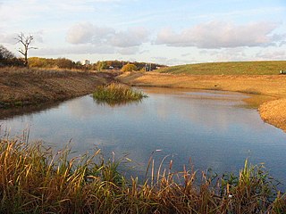
The River Crane, a tributary of the River Thames, runs 8.5 miles (13.6 km) in West London, England. It forms the lower course of Yeading Brook. It adjoins or passes through three London boroughs: Hillingdon, Hounslow and Richmond upon Thames, in the historic county of Middlesex. The drainage basin is heavily urbanised but many of the Hayes to Whitton flood-meadows have been conserved, forming a narrow, green vale, opening out to what remains of Hounslow Heath in the centre – a near-continuous belt of semi-natural habitat.

Elthorne was a hundred of the historic county of Middlesex, England.

The A312 is an A road in England, running across west London from Hampton to Harrow. Its status varies from a local urban street to a major dual carriageway in Hayes. Part the road has been diverted to make way for Heathrow Airport, while another stretch was originally planned to be Ringway 3, one of four major ring motorways around London.
Hayes & Yeading United Football Club is an association football club based in Hayes, in the London Borough of Hillingdon, England. The club was formed in 2007 from a merger of Hayes Football Club and Yeading Football Club. It currently competes in the Southern League Premier Division South and plays its home matches at the Skyex Community Stadium.

Yeading Brook is the dominant source of the River Crane, in outer North West then West London. The western branch flows 25.8 km (16.0 mi) south. It rises in the far south of suburban Pinner and drains all of the western suburbs of Harrow, insofar as they have not been by historical practice connected into sewers.

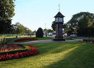
Barra Hall Park is an 11.06-hectare (27.3-acre) formal park situated near the centre of Hayes in the ward of Wood End in the London Borough of Hillingdon. The park came into existence in December 1923.
Barnhill Community High School, sometimes shortened to Barnhill, is a coeducational secondary school located in the Yeading area of the London Borough of Hillingdon, England. In 2012 the school converted to an academy.
Minet Country Park is a 36-hectare park on Springfield Road, Hayes in the London Borough of Hillingdon; it is situated between the A312 and the Uxbridge Road.

St Mary the Virgin Church is a partly medieval Grade II* listed flint church on Church Road in Hayes, Hillingdon. The central portion of the church, the chancel and the nave, was built in the 13th century, the north aisle in the 15th century, and the south aisle in the 16th century, along with the lychgate and the south porch.


