This is a list of public art in the London Borough of Harrow .
This is a list of public art in the London Borough of Harrow .
| Image | Title / subject | Location and coordinates | Date | Artist / designer | Type | Designation | Notes |
|---|---|---|---|---|---|---|---|
| Subway mural | Belmont Trail subway, near medical centre and St Joseph's Catholic Primary School 51°36′04″N0°19′11″W / 51.6012°N 0.3198°W | 2012 | Harrow Arts Centre and Alistair Lambert working with St Joseph's Catholic Primary School | Mural | — | [1] |
| Image | Title / subject | Location and coordinates | Date | Artist / designer | Type | Designation | Notes |
|---|---|---|---|---|---|---|---|
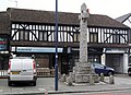 | Edgware War Memorial | High Street 51°36′41″N0°16′49″W / 51.6113°N 0.2802°W | 1920 | ? | Celtic cross | Grade II | Unveiled 27 March 1920. [2] |
| Image | Title / subject | Location and coordinates | Date | Artist / designer | Type | Designation | Notes |
|---|---|---|---|---|---|---|---|
 More images | Greenhill War Memorial | St John's churchyard 51°34′58″N0°19′54″W / 51.58266°N 0.3318°W | 1951 | ? | Pillar | Grade II | [3] |
| Image | Title / subject | Location and coordinates | Date | Artist / designer | Type | Designation | Notes |
|---|---|---|---|---|---|---|---|
 More images | Skipping Girl | St Ann's Road 51°34′53″N0°20′01″W / 51.5813°N 0.3337°W | 1987 | James Butler | Statue | — | [4] |
| The Leaf | The Grove Field, Lowlands Road, Harrow 51°34′40″N0°20′16″W / 51.5779°N 0.3377°W | 1994 | Diane Maclean | Sculpture | — | [5] | |
 | Harrow War Memorial | Station Road, outside Harrow Civic Centre 51°35′23″N0°19′59″W / 51.5898°N 0.3330°W | 2005 | ? | Pillar/column | — | [6] |
| Inner View | Alexandra Park, South Harrow | 2007 | Lorraine Benton | Sculpture | — | [7] | |
| Mural | Kymberley Road, on wall of St George's Shopping Centre 51°34′52″N0°20′02″W / 51.5810°N 0.3340°W | 2014 | Local people | Mural | — | [8] |
| Image | Title / subject | Location and coordinates | Date | Artist / designer | Type | Designation | Notes |
|---|---|---|---|---|---|---|---|
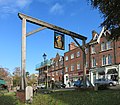 | Gantry with portrait of Henry VIII | Junction of High Street and Byron Hill Road 51°34′13″N0°20′23″W / 51.5704°N 0.3397°W | c. 1780 | Restored and placed on current site in 2010. [9] | |||
 | Statue of Elizabeth I | Harrow School, on south tower of Speech Room, overlooking Peterborough Road 51°34′25″N0°20′12″W / 51.5737°N 0.3367°W | c. 1820 | Richard Westmacott | Statue in niche | Grade II* | Originally at Ashridge Park, Hertfordshire, the statue was moved to Harrow School in 1925. [10] [11] |
 | Thomas Charles Hudson Drinking Fountain | Junction of High Street and West Street 51°34′20″N0°20′17″W / 51.5722°N 0.3381°W | 1880 | ? | Drinking fountain | Grade II | [12] |
 More images | Harrow on the Hill War Memorial | Grove Hill, at junction with Lowlands Road 51°34′37″N0°20′07″W / 51.5769°N 0.3354°W | 1921 | W. D. Caröe | Memorial cross | Grade II | [13] |
| Memorial to Britain's first recorded fatal car accident, in 1899 | Junction of Peterborough Road and Grove Hill 51°34′25″N0°20′11″W / 51.5737°N 0.3364°W | 1969 | [14] | ||||
 | Hygeia | College Road | 1991 | ? | Architectural sculpture | — | [15] |
| Charles I commemorative plaque | Grove Hill 51°34′27″N0°20′10″W / 51.5742°N 0.3361°W | [16] | |||||
| Two eagles | 70 High Street, on top of porch 51°34′16″N0°20′21″W / 51.57115°N 0.33906°W | [17] |
| Image | Title / subject | Location and coordinates | Date | Artist / designer | Architect / other | Type | Designation | Notes |
|---|---|---|---|---|---|---|---|---|
 | Harrow Weald War Memorial | High Road, at junction with Box Tree Road 51°36′27″N0°20′25″W / 51.6074°N 0.3404°W | 1917 | L. F. W. Deacon and J. C. Rackham | Street shrine | — | [18] | |
 | Crucifixion with Saints | St Joseph's Church, High Road | 1931 | ? | Adrian Gilbert Scott | Architectural sculpture | [19] |
| Image | Title / subject | Location and coordinates | Date | Artist / designer | Architect / other | Type | Designation | Notes |
|---|---|---|---|---|---|---|---|---|
 More images | Tooke Drinking Fountain William Arthur Tooke JP | Church Lane 51°35′36″N0°22′30″W / 51.5932°N 0.3749°W | 1886 | ? | — | Drinking fountain | Grade II | [20] |
 More images | Pinner War Memorial | High Street, near junction with Grange Gardens 51°35′40″N0°22′47″W / 51.5944°N 0.3798°W | 1921 | Bertram Mackennal | — | Pillar/column | Grade II | [21] |
 | Saint Luke Painting the Virgin | St Luke's Church, Love Lane | 1957 | David John | Francis Xavier Velarde | Architectural sculpture | Grade II | [22] |
| Image | Title / subject | Location and coordinates | Date | Artist / designer | Architect / other | Type | Designation | Notes |
|---|---|---|---|---|---|---|---|---|
 | Saint Andrew | St Andrew's Church, Malvern Avenue | 1957 | Darsie Rawlins | Farey & Adams | Architectural sculpture | Grade II | [23] |
| Image | Title / subject | Location and coordinates | Date | Artist / designer | Type | Designation | Notes |
|---|---|---|---|---|---|---|---|
 More images | Stanmore War Memorial | St John's churchyard 51°36′58″N0°18′55″W / 51.6161°N 0.3152°W | 1920 | ? | Celtic cross | Grade II | Unveiled 22 July 1922. [24] |
| Image | Title / subject | Location and coordinates | Date | Artist / designer | Type | Designation | Notes |
|---|---|---|---|---|---|---|---|
| More images | Wealdstone War Memorial | Junction of Spencer Road and High Street 51°35′50″N0°20′09″W / 51.5972°N 0.3359°W | 1923 | Harold F. Walker and J. C. Rackham | Clock tower | Grade II | [25] |
| Mural commemorating the Harrow and Wealdstone rail crash | Outside Harrow & Wealdstone station 51°35′32″N0°20′03″W / 51.5922°N 0.3343°W | 2004 | Local schoolchildren | Mural | — | [26] |
| Districts |
|   | ||
|---|---|---|---|---|
| Attractions | ||||
| Parks and open spaces | ||||
| Constituencies | ||||
| Tube and rail stations | ||||
| Other topics | ||||