
Stanmore is part of the London Borough of Harrow in Greater London. It is centred 11 miles (18 km) northwest of Charing Cross, lies on the outskirts of the London urban area and includes Stanmore Hill, one of the highest points of London, at 152 metres (499 ft) high. The district, which developed from the ancient Middlesex parishes of Great and Little Stanmore, lies immediately west of Roman Watling Street and forms the eastern part of the modern London Borough of Harrow.

The London Borough of Harrow is a London borough in northwest London, England; it forms part of Outer London. It borders four other London boroughs – Barnet to the east of ancient Watling Street, Brent to the southeast, Ealing to the south and Hillingdon to the west and the Hertfordshire districts of Three Rivers and Hertsmere to the north. The local authority is Harrow London Borough Council. The London borough was formed in 1965, based on boundaries that had been established in 1934. The borough is made up of three towns: Harrow, Pinner and Stanmore, but also includes western parts of Edgware.

Ashdown Forest is an ancient area of open heathland occupying the highest sandy ridge-top of the High Weald Area of Outstanding Natural Beauty. It is situated 30 miles (48 km) south of London in the county East Sussex, England. Rising to an elevation of 732 feet (223 m) above sea level, its heights provide expansive vistas across the heavily wooded hills of the Weald to the chalk escarpments of the North Downs and South Downs on the horizon.

Harrow is a large town in Greater London, England, and serves as the principal settlement of the London Borough of Harrow. Lying about 9.5 miles (15.3 km) north-west of Charing Cross and 5.4 miles (8.7 km) south of Watford, the entire town including its localities had a population of 149,246 at the 2011 census, whereas the wider borough had a population of 250,149.

Harrow Weald is a suburban district in Greater London, England. Located about 2 miles (3.2 km) north of Harrow, Harrow Weald is formed from a leafy 1930s suburban development along with ancient woodland of Harrow Weald Common. It forms part of the London Borough of Harrow.
The London Borough of Harrow is one of the northern outer London boroughs: as such much of the Metropolitan Green Belt land is within the Borough boundaries. Parks and open spaces range from the large area around Harrow-on-the-Hill to the smaller gardens and recreation grounds; there are also a number of spaces taken up with golf courses. It has been suggested that Harrow is continuously losing its green space and trees.

Grim's Ditch, Grim's Dyke or Grim's Bank is a name shared by a number of prehistoric bank and ditch linear earthworks across England. They are of different dates and may have had different functions.
Mitcham Common is 182 hectares (460 acres) of common land situated in south London. It is predominantly in the London borough of Merton, with parts straddling the borders of Croydon and Sutton. It is designated a Site of Metropolitan Importance for Nature Conservation.

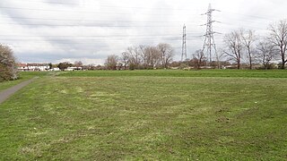
Grim's Ditch or Grim's Dyke or Grimes Dike is a linear earthwork in the London Borough of Harrow, in the historic county of Middlesex. Thought to have been built by the Catuvellauni tribe as a defence against the Romans, it extended east–west about 6 miles (9.7 km) from the edge of Stanmore where an elevated neighbourhood of London, Stanmore Hill, adjoins Bushey Heath to the far north of Pinner Green – Cuckoo Hill. Today the remaining earthworks start mid-way at Harrow Weald Common.
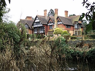
Grim's Dyke is a house and estate in Harrow Weald, in northwest London, England. The house was built from 1870 to 1872 by Richard Norman Shaw for painter Frederick Goodall and named after the nearby prehistoric earthwork known as Grim's Ditch. It was converted into a hotel, Grim's Dyke Hotel, in 1970.

Bentley Priory is an eighteenth to nineteenth century stately home and deer park in Stanmore on the northern edge of the Greater London area in the London Borough of Harrow.

Stanmore Country Park is a 30.7-hectare (76-acre) public park, Local Nature Reserve and Site of Metropolitan Importance for Nature Conservation in Stanmore in the London Borough of Harrow. It is owned and managed by Harrow London Borough Council.

Stanmore Common is a 49.2-hectare public park, Local Nature Reserve and Site of Metropolitan Importance for Nature Conservation in Stanmore in the London Borough of Harrow in England. It is owned by Harrow Council and managed by the council with a local group. It was a biological Site of Special Scientific Interest, but was de-notified in the early 1990s.
The common land of Ashdown Forest in East Sussex, England, a former royal hunting forest created soon after the Norman conquest of England, covers some 6,400 acres. The map of the common land today largely dates back to 1693, when more than half the medieval Forest was taken into private hands, with the remainder being set aside as common land. The latter is today administered by a Board of Conservators. It is entirely open for public access and it is the largest area of its kind in South East England.
Pinner Green is a small area of Pinner, in the north-west of the London Borough of Harrow, 13.2 miles north-west of Charing Cross. It is a suburban area mostly occupied by family houses and flats, with a small parade of independent shops, a Tesco supermarket and a modern Shell forecourt.

Bentley Priory Nature Reserve is a Site of Special Scientific Interest and Local Nature Reserve in Stanmore in the London Borough of Harrow, surrounding the stately home of Bentley Priory. It is a 55 hectare mosaic of ancient woodland, unimproved neutral grassland, scrub, wetland, streams and an artificial lake, an unusual combination of habitats in Greater London.

Keston Common is a 55 hectare area of public open space in Keston in the London Borough of Bromley. Most of it is heathland and dry acid grassland on the Blackheath Pebble Beds. Almost all the common together with a small part of the neighbouring Hayes Common is a biological Site of Special Scientific Interest.

Harrow Weald SSSI is a 3.7 hectare geological Site of Special Scientific Interest in Harrow Weald in the London Borough of Harrow. It was formerly part of the Stanmore and Harrow Weald Commons and Bentley Priory SSSI. It is a Geological Conservation Review site.

Riddlesdown Common or Riddlesdown is a 43 hectare area of green space in Kenley, towards the northern end of the North Downs in the London Borough of Croydon. It is owned and maintained by the City of London Corporation, apart from two small areas, one of which is operated by the London Wildlife Trust and the other by Croydon Council. An area of 32 hectares is a biological Site of Special Scientific Interest. The name Riddlesdown also applies to the local district of residential housing. A trig point at the site indicates that it is 525 ft (160 m) above sea level.


