
The London Borough of Havering in East London, England, forms part of Outer London. It has a population of 259,552 inhabitants; the principal town is Romford, while other communities are Hornchurch, Upminster, Collier Row and Rainham. The borough is mainly suburban, with large areas of protected open space. Romford is a major retail and night time entertainment centre, and to the south the borough extends into the London Riverside redevelopment area of the Thames Gateway. The name Havering is a reference to the Royal Liberty of Havering which occupied the area for several centuries. The local authority is Havering London Borough Council. It is the easternmost London borough.

Ardleigh Green is an area in east London, England, within the London Borough of Havering. It is 15.5 miles (25 km) east-northeast of Charing Cross. This part of London is predominantly residential.
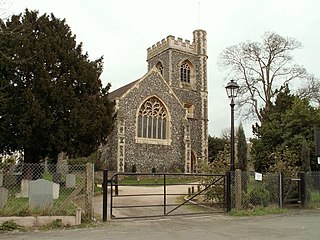
Havering-atte-Bower is a village and outlying settlement of Greater London, England. It is located in the far north of the London Borough of Havering, on the border with Essex, and is 15 miles (24 km) northeast of Charing Cross. It was one of three former parishes whose area comprised the historic Royal Liberty of Havering.
Havering Palace was an old royal residence in England. Between its building before 1066 until its abandonment in 1686 it was in the village of Havering-atte-Bower. By 1816 no walls remained above ground.

Romford is a constituency represented in the House of Commons of the UK Parliament since 2001 by Andrew Rosindell, a Conservative. It was created in 1885.

Hornchurch was a local government district in southwest Essex from 1926 to 1965, formed as an urban district for the civil parish of Hornchurch. It was greatly expanded in 1934 with the addition of Cranham, Great Warley, Rainham, Upminster and Wennington; and in 1935 by gaining North Ockendon. Hornchurch Urban District Council was based at Langtons House in Hornchurch from 1929. The district formed a suburb of London and with a population peaking at 131,014 in 1961, it was one of the largest districts of its type in England. It now forms the greater part of the London Borough of Havering in Greater London.

Romford was a local government district in southwest Essex from 1851 to 1965. It was significantly expanded in 1934 and gained the status of municipal borough in 1937. The population density of the district consistently increased during its existence and its former area now corresponds to the northern part of the London Borough of Havering in Greater London.

Stapleford Abbotts is a village and civil parish in the Epping Forest district of Essex, approximately 5.5 mi (9 km) SW of Ongar, 4.5 mi (7 km) N of Romford and 5 mi (8 km) SSE of Epping. The whole parish is within the M25 motorway. The village covers 957 hectares and had a population of 959 in 2001, increasing to 1,008 at the 2011 Census.
The Round House is a Grade II* listed late Georgian elliptical stuccoed villa located on Broxhill Road in Havering-atte-Bower, London. The house was built between 1792 and 1794 by John Plaw for William Sheldon. The house is open as part of the Open House London weekend.

Bedfords Park is public open space of 215 acres or approximately 87½ hectares near Havering-atte-Bower in the London Borough of Havering in England. It is one of three large parklands around Havering-atte-Bower; the others are Havering Country Park and Pyrgo Park.
Pyrgo Park is a park at Havering-atte-Bower in the London Borough of Havering, in North East London, England. It is the site of the former Pirgo Palace, built before 1540 and demolished by 1814; and of Pyrgo House, built 1852, which lasted less than a century.

The M12 motorway was a planned motorway starting in north-east London and joining the A12 road in Essex. The 1960s scheme would have started at a junction with the M11 motorway and North Circular and ended near Brentwood, Chelmsford, or at the proposed new Maplin Sands airport; the motorway was part of the ambitious London Ringways plan to build motorways throughout London. Although most of the Ringways plan was cancelled in 1969 the M12 motorway project was still included in the Roads for Prosperity white paper published in 1989 along with major proposed developments to the A12 road. It was not formally cancelled until 30 March 1994 by the Secretary of State for Transport, John MacGregor.
Gidea Hall was a manor house in Gidea Park, the historic parish and Royal liberty of Havering-atte-Bower, whose former area today is part of the north-eastern extremity of Greater London.
St. John the Evangelist Church refers to churches honoring John the Apostle, also known as John the Divine or John of Patmos, as their patron saint but distinguished from John the Baptist. Thus, the designation may refer to:
Passingford Bridge is a bridge over the River Roding, and a surrounding hamlet, in the parish of Stapleford Abbotts in the Epping Forest district of Essex, England. It is located just within the northeastern bounds of the M25 motorway and is surrounded by Metropolitan Green Belt. It is within the RM postcode area. It is served as an outlier of the London Buses network, forming the northern terminus of route 375 from Romford.

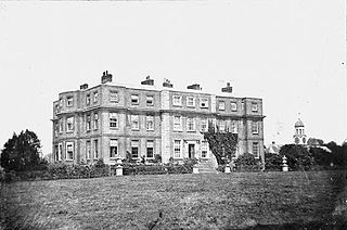
The Bower House is a grade I listed Palladian mansion in Havering-atte-Bower, England. It was built in 1729 by Henry Flitcroft. The stable block is separately grade I listed. It incorporated architectural items salvaged from the ruined Havering Palace. It remained a private home until 1976 when it was purchased by the Ford Motor Company. It is currently used as a Christian training centre. It forms part of the Open House London weekend.

Havering Country Park is a varied environment open space in the London Borough of Havering. It includes 100 acres (0.40 km2) of woodland.
Sir Thomas Tipping was a late 17th-century English baronet and Member of Parliament.
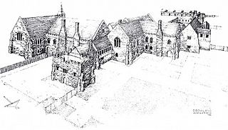
Hornchurch Priory was an alien priory in Hornchurch, now in the London Borough of Havering. It was founded in 1158/9 on land donated by Henry II. The priory later amassed additional land holdings. For over 200 years the priory dominated the spiritual life of Havering as well as acting as landlord over much of Hornchurch. Its lands were seized by the Crown in 1385 and bought for New College, Oxford in 1391.

Marks was a manor house located near Marks Gate at the northern tip of the London Borough of Barking and Dagenham in London, England, the house standing on what is now Warren Hall Farm, about two miles west of Romford. The name Marks is believed to have been derived from the de Merk family who built the original manor in the 14th century. The manor house was demolished in 1808.


