Related Research Articles

Cranham is a residential area of east London, and part of the London Borough of Havering. It is located 17.5 miles (28 km) east-northeast of Charing Cross and comprises an extensive built-up area to the north and a low density conservation area to the south surrounded by open land. It was historically a rural village in the county of Essex and formed an ancient parish. It is peripheral to London, forming the eastern edge of the urban sprawl. The economic history of Cranham is characterised by a shift from agriculture to housing development. As part of the suburban growth of London in the 20th century, Cranham significantly increased in population, becoming part of Hornchurch Urban District in 1934 and has formed part of Greater London since 1965. The 2011 Census population of Cranham was included in Upminster.

Harold Wood is a suburban neighbourhood in East London in the London Borough of Havering. It is situated 16.5 miles (26.6 km) east-northeast of Charing Cross. Harold Wood was part of the ancient parish of Hornchurch, which became the Liberty of Havering. Most of the current area of Harold Wood became part of Hornchurch Urban District in 1926. It is near to the Greater London boundary with Essex.

Hornchurch is a suburban town in East London the London Borough of Havering. It is located 15.2 miles (24.5 km) east-northeast of Charing Cross. It comprises a number of shopping streets and a large residential area. It historically formed a large ancient parish in the county of Essex that became the manor and liberty of Havering. The economic history of Hornchurch is underpinned by a shift away from agriculture to other industries with the growing significance of nearby Romford as a market town and centre of administration. As part of the suburban growth of London in the 20th century, Hornchurch significantly expanded and increased in population, becoming an urban district in 1926 and has formed part of Greater London since 1965. It is the location of Queen's Theatre, Havering Sixth Form College and Havering College of Further and Higher Education.

Romford is a large town in East London and the administrative centre of the London Borough of Havering. It is located 14 miles northeast of Charing Cross and is one of the major metropolitan centres identified in the London Plan. Historically, Romford was a market town in the county of Essex, and formed the administrative centre of the liberty of Havering before that liberty was dissolved in 1892. Good road links to London and the opening of the railway station in 1839 were key to the development of the town. The economic history of Romford is characterised by a shift from agriculture to light industry and then to retail and commerce. As part of the suburban growth of London throughout the 20th century, Romford significantly expanded and increased in population, becoming a municipal borough in 1937 and was incorporated into Greater London in 1965. Today, it is one of the largest commercial, retail, entertainment and leisure districts in London and has a well-developed night-time economy. Its population, as of 2011, was 122,854.

The London Borough of Havering in East London, England, forms part of Outer London. It has a population of 259,552 inhabitants; the principal town is Romford, while other communities are Hornchurch, Upminster, Collier Row and Rainham. The borough is mainly suburban, with large areas of protected open space. Romford is a major retail and night time entertainment centre, and to the south the borough extends into the London Riverside redevelopment area of the Thames Gateway. The name Havering is a reference to the Royal Liberty of Havering which occupied the area for several centuries. The local authority is Havering London Borough Council. It is the easternmost London borough.
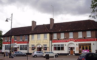
Elm Park is a suburban planned community in East London and part of the London Borough of Havering. Located 14.3 miles (23.0 km) east-northeast of Charing Cross, it is identified as a district centre in the London Plan with several streets of shops and a priority for regeneration. Prior to the construction of the extensive Elm Park Garden City development in the 1930s it was a scattered settlement of farms in the south of the parish of Hornchurch. Elm Park has been connected to central London by the electrified District line service since 1935 and the planned development of the area formed part of the interwar private housing boom that was interrupted by World War II. After the war Elm Park expanded with social housing and it has formed part of Greater London since 1965.
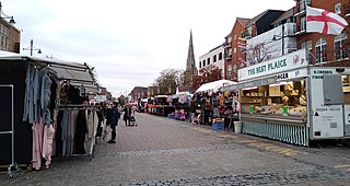
Romford Market is a large outdoor retail market located in Romford in the London Borough of Havering, England. The market right was established by royal order in 1247. Rival markets are prohibited within 6.66 miles (10.72 km). Governance of the market was strengthened by the 1465 charter of the Liberty of Havering, which was administered from a court house at the western end of the market. Formerly a livestock and agricultural market, cattle was last sold in 1958. The market has been in local authority ownership since it was purchased by the Romford Local Board in 1892 and is now owned by Havering Council. The marketplace was located on the main east–west road through the town until traffic was diverted away from the market in 1969. The market is promoted as a filming location. It is open on Wednesday, Friday, Saturday and Sunday. As of July 2020 it has 60 licensed traders, down from a peak of over 300.
Langtons House and Langtons Gardens are a grade II listed 18th century house and landscaped gardens located in Hornchurch, in the London Borough of Havering, Greater London. The house and gardens became local authority property in 1929 and are currently used as the borough register office and a public park. Langtons House was used as the council offices of Hornchurch Urban District Council from 1929 to 1965.

Romford is a constituency represented in the House of Commons of the UK Parliament since 2001 by Andrew Rosindell, a Conservative. It was created in 1885 and was subject to significant changes in boundaries in 1918 and 1945. It initially covered a huge swathe of what is now East London, with parts of the constituency progressively removed as they experienced significant increases in population as London expanded. The constituency has more or less coincided with the town of Romford since 1955.

Hornchurch was a local government district in southwest Essex from 1926 to 1965, formed as an urban district for the civil parish of Hornchurch. It was greatly expanded in 1934 with the addition of Cranham, Great Warley, Rainham, Upminster and Wennington; and in 1935 by gaining North Ockendon. Hornchurch Urban District Council was based at Langtons House in Hornchurch from 1929. The district formed a suburb of London and with a population peaking at 131,014 in 1961, it was one of the largest districts of its type in England. It now forms the greater part of the London Borough of Havering in Greater London.

Hornchurch and Upminster is a constituency in Greater London represented in the House of Commons of the UK Parliament by Julia Lopez, a member of the Conservative Party, currently Minister of State for Media, Tourism and Creative Industries, who succeeded Angela Watkinson in 2017. Watkinson had been elected in 2010 as the constituency's first MP.

Ingrebourne Valley is a local nature reserve (LNR) in Hornchurch in the London Borough of Havering. It is owned and managed by Havering Council, and has a visitor centre managed by the Essex Wildlife Trust. Most of it is in Hornchurch Country Park west of the River Ingrebourne, but there are also areas north and south of the park which are part of the LNR. It has a wide range of habitats, including woodland, grassland, the river and marshes. It is an important site for a range of species of plants, animals and birds, including great crested newts, slow worms, the harvest mouse and the water vole.

Beam Park is a new neighbourhood in the south of the London Borough of Barking and Dagenham and the London Borough of Havering. It is named after the River Beam which forms the boundary between the boroughs. It is part of the London Riverside opportunity area and is designated with neighbouring Rainham as a housing zone by the Greater London Authority. It covers an area of 29 hectares. It will include a town centre in the Havering part of the development and will be served by Beam Park railway station. Much of the land previously part of the Ford Dagenham site is being redeveloped as a joint venture between London and Quadrant and Countryside Properties. Planning consent for 3,000 homes was issued in February 2019 and construction began in May 2019. The first residents moved into Beam Park in December 2020. Planning permission was given for 947 additional homes in December 2022

Hornchurch Marshes is an area of the London Borough of Havering, adjacent to the north bank of the River Thames in London, England. Susceptible to flooding from three adjacent rivers, it was the southernmost marshland section of the ancient parish of Hornchurch. It was used for cattle grazing from the 16th to the 19th century and became industrialised by the 20th century. The eastern part of the Ford Dagenham estate extended into the Hornchurch Marshes and it is now an area of regeneration that includes Beam Reach and part of Beam Park. Two of the Dagenham wind turbines are located there and the Centre for Engineering and Manufacturing Excellence.
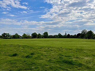
Hylands Park is a public park in the London Borough of Havering in northwest Hornchurch, near to Romford. It is owned and managed by Havering London Borough Council and has Green Flag Award status.

Rainham is a suburb of East London, England, in the London Borough of Havering. Historically an ancient parish in the county of Essex, Rainham is 13.6 miles (21.9 km) east of Charing Cross and is surrounded by a residential area, which has grown from the historic village, to the north and a commercial area, fronting the River Thames, to the south. As part of the suburban growth of London in the 20th century, Rainham significantly expanded and increased in population, becoming part of Hornchurch Urban District in 1934, and has formed part of Greater London since 1965. The economic history of Rainham is underpinned by a shift from agriculture to industry and manufacture and is now in a period of regeneration, coming within the London Riverside section of the Thames Gateway redevelopment area.
Havering Residents Association (HRA) is a group of residents' associations and registered political party in London, England. It is active in the London Borough of Havering and as of 2023 forms a 21-councillor group on Havering London Borough Council. At the 2022 London borough council elections they were the largest party on Havering Council, largest elected residents group in London, and the fourth largest political party represented on all London borough councils. Not all residents groups in Havering are affiliated to the HRA, usually indicating this by standing as 'independent resident' candidates. In 2014 eight members of the Havering Residents Association group split off to form the East Havering Residents Group.

St Andrew's is an electoral ward in the London Borough of Havering. The ward has existed since the creation of the borough on 1 April 1965 and was first used in the 1964 elections. It returns three councillors to Havering London Borough Council.

The 2022 Havering London Borough Council election is currently taking place as of 5 May 2022. All 55 members of Havering London Borough Council will be elected. The elections will take place alongside local elections in the other London boroughs and elections to local authorities across the United Kingdom.
St Andrew's Park is a public park in Hornchurch, in the London Borough of Havering. It is owned and managed by Havering London Borough Council.
References
- ↑ "Definitive Map of Special Review of Public Rights of Way 1971" (PDF). Havering London Borough Council. 28 April 1971. Retrieved 23 August 2023.
- ↑ Marsh, Alex (23 July 2023). "Havering receives 16 Green Flag park awards from charity". Romford Recorder. Retrieved 23 August 2023.


