The Isle of Dogs is a large peninsula bounded on three sides by a large meander in the River Thames in East London, England. It includes the Cubitt Town, Millwall and Canary Wharf districts. The area was historically part of the Manor, Hamlet, Parish and, for a time, the wider borough of Poplar. The name had no official status until the 1987 creation of the Isle of Dogs Neighbourhood by Tower Hamlets London Borough Council. It has been known locally as simply "the Island" since the 19th century.
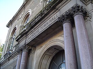
Limehouse is a district in the London Borough of Tower Hamlets in East London. It is 3.9 miles (6.3 km) east of Charing Cross, on the northern bank of the River Thames. Its proximity to the river has given it a strong maritime character, which it retains through its riverside public houses and steps, such as The Grapes and Limehouse Stairs.

Poplar is a district in East London, England and is in the London Borough of Tower Hamlets. It is an inner-city suburb located five miles (8 km) east of Charing Cross. It lies on the western bank of the River Lea and is part of the London Docklands.

Stepney is an area in the London Borough of Tower Hamlets in the East End of London. Stepney is no longer officially defined, and is usually used to refer to a relatively small area. However, for much of its history the place name was applied to a much larger manor and parish. Stepney Green is a remnant of a larger area of Common Land formerly known as Mile End Green.

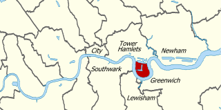
The London Borough of Tower Hamlets is a borough in London, England. Situated on the north bank of the River Thames and immediately east of the City of London, the borough spans much of the traditional East End of London and includes much of the regenerated London Docklands area. The 2019 mid-year population for the borough is estimated at 324,745.

The Metropolitan Borough of Stepney was a Metropolitan borough in the County of London created in 1900. In 1965 it became part of the London Borough of Tower Hamlets.

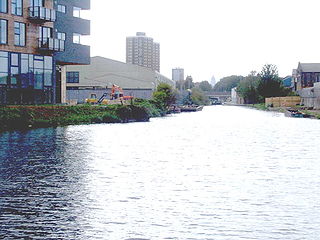
The Limehouse Cut is a largely straight, broad canal in the East End of London which links the lower reaches of the Lee Navigation to the River Thames. Opening on 17 September 1770, and widened for two-way traffic by 1777, it is the oldest canal in the London area. Although short, it has a diverse social and industrial history. Formerly discharging directly into the Thames, since 1968 it has done so indirectly by a connection through Limehouse Basin.
The Hertford Union Canal or Duckett's Cut, just over 1 mile (1.6 km) long, connects the Regent's Canal to the Lee Navigation in the London Borough of Tower Hamlets in East London. It was opened in 1830 but quickly proved to be a commercial failure. It was acquired by the Regents Canal Company in 1857, and became part of the Grand Union Canal in 1927.

Mile End is an area in London, England and is located in the London Borough of Tower Hamlets. It is in East London and part of the East End. It is 4.2 miles (6.8 km) east of Charing Cross. Situated on the part of the London-to-Colchester road called Mile End Road, it was one of the earliest suburbs of London.

Cubitt Town is a district on the eastern side of the Isle of Dogs in London, England. This part of the former Metropolitan Borough of Poplar was redeveloped as part of the Port of London in the 1840s and 1850s by William Cubitt, Lord Mayor of London (1860–1862), after whom it is named. It is on the east of the Isle, facing the Royal Borough of Greenwich across the River Thames. To the west is Millwall, to the east and south is Greenwich, to the northwest Canary Wharf, and to the north — across the Blue Bridge — is Blackwall. The district is situated within the Blackwall & Cubitt Town Ward of Tower Hamlets London Borough Council.

East London is the northeastern part of London, England, east of the ancient City of London and north of the River Thames as it begins to widen. East London developed as London's docklands and the primary industrial centre. The expansion of railways in the 19th century encouraged the eastward expansion of the East End of London and a proliferation of new suburbs. The industrial lands of East London are today an area of regeneration, which are well advanced in places such as Canary Wharf and ongoing elsewhere.

Walking is a popular recreational activity in London, despite traffic congestion. There are many streets that provide interesting walks, especially within historic central London. In addition there are attractive commons, parks, canals, and disused railway tracks that provide space for walks. This includes Wimbledon Common, Epping Forest, Hampstead Heath, and the eight Royal Parks: Hyde Park, Regent's Park, Richmond Park, etc. In recent years access to canals and rivers, including the Regent's Canal, and the River Thames has been greatly improved, and as well a number of long-distance walking routes have been created that link green spaces.

The London Borough of Newham, in spite of being one of the more crowded areas of London, has over 20 parks within its boundaries, as well as smaller recreation grounds. The larger parks in the Borough include:

The London Borough of Hackney, one of the inner London boroughs, has 62 parks, gardens and open spaces within its boundaries, totalling 330 ha. These provide the "green lungs" for leisure activities. Hackney Marshes contain the largest concentration of football pitches in Europe.

The London Borough of Islington is short of large parks and open spaces, given its status in recent decades as a desirable place of residence. In fact, Islington has the lowest ratio of open space to built-up areas of any London borough. The largest continuous open space in the borough, at 11.75 hectares, is Highbury Fields.

Old Ford is an area in the London Borough of Tower Hamlets that is named after the natural ford which provided a crossing of the River Lea.

Mudchute Park and Farm is a large urban park and farm in Cubitt Town on the Isle of Dogs in the London Borough of Tower Hamlets, just south of Canary Wharf. It is a Local Nature Reserve and a Site of Metropolitan Importance for Nature Conservation.

National Cycle Route 1 is a route of the United Kingdom National Cycle Network, running from Dover to Tain. The 1,264 mi-long (2,034-kilometre) cycle-path is located in the United Kingdom.

King Edward Memorial Park is a public open space in the London Borough of Tower Hamlets, on the northern bank of the River Thames.


