Old Ford

Last updated

Old Ford
Fish island sculptures.jpg
Sculptures in Old Ford
Greater London UK location map 2.svg
Red pog.svg
Old Ford
Location within Greater London
OS grid reference TQ365835
London borough
Ceremonial county Greater London
Region
Country England
Sovereign state United Kingdom
Post town LONDON
Postcode district E3
Dialling code 020
Police Metropolitan
Fire London
Ambulance London
UK Parliament
London Assembly
List of places
UK
England
London
51°32′06″N0°01′19″W / 51.535°N 0.022°W / 51.535; -0.022

Old Ford is an area in the London Borough of Tower Hamlets that is named after the natural ford which provided a crossing of the River Lea. [1]

Contents

History

Administration and boundaries

Historically, Old Ford was a cluster of houses and a mill, around the ford. It formed a part of the Ancient Parish of Stepney. Together with the rest of Bow, it separated from Stepney to become a (late formed) Ancient Parish of Bow in 1719. [2] Ancient Parishes were, until the 19th century responsible for both civil and ecclesiastical local administration, after that there were divergent civil and ecclesiastical parish areas.

It expanded rapidly in the Victorian era into a suburb of London and was designated an independent Anglican parish in the mid-Victorian period, although civil administration has always been associated with Bow.

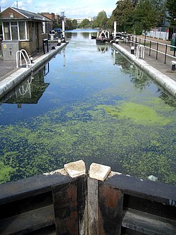
Location of the ford

Victorian OS maps show an illustrative location of the, by then, former ford, which was just to the south of the Northern Outfall Sewer and immediately south of the confluence of the Lea and the Hackney Brook. The confluence is likely to have caused the Lea to eddy and slow, causing much alluvial material from both watercourses to be dropped at this point, which may have been the reason that fording the river was possible here. This may have been reinforced by the fact that the Lea's tidal head was in the vicinity. [3]

Excavations have shown that in the Roman period, the ford lay a very short distance to the north of this point, immediately north of the Northern Outfall Sewer. The Romans dumped materials to improve the ford and at one time appear to have had a bridge over the Lea. [4]

Evidence has been found of a late Roman settlement at Old Ford dating from the 4th and 5th centuries. Excavations in 200203 discovered a substantial 'ribbon' development along the line of the road, surrounded by fields. Near the river there was evidence for a cluster of wooden buildings dominated by a large open-ended barn. Large amounts of cattle bone were also discovered, suggesting butchery to supply the London market. The Lea was thought to be used to supply Roman London with agricultural products and pottery from Hertfordshire and the north. Old Ford was where the goods were transferred to continue their journey into London by wagon. [5]

Routes using the ford

Old Ford, as the name suggests, was the ancient most downstream crossing point of the then unchannelised River Lea. At this time the Lea was a wide fast-flowing river and the tidal estuary stretched as far as Hackney Wick. [3]

Two routes may have used the ford, both continuing through Essex and including Colchester amongst their destinations. Colchester [6] was where the Romans set up their initial capital for their occupation, and the road was upgraded to run from the area of London Bridge as one of the first paved Roman roads in Britain.

The routes using the ford were:

After the bridge

In 1110, Matilda, wife of Henry I, reputedly took a tumble at the ford on her way to Barking Abbey and ordered a distinctively bow-shaped three-arched bridge to be built over the River Lea.

The building of the bridge at Bow did not leave Old Ford as a backwater and the ford continued to be well used, but it was in an isolated and rural area and the local population centre moved to Bow in the Middle Ages. Old Ford was the site of one of the many watermills in the area that supplied flour to the bakers of Stratforde-atte-Bow, and hence bread to the City. Due to their isolation, residents were given dispensation to worship in the chapel of ease at Stratforde-atte-Bow, later Bow Church, to save the often difficult journey to the parish church of St Dunstan's at Stepney.

A lock and weir now exist on the Lee Navigation near where the ford used to be. This lies at the end of 'Hackney Cut', an 18th-century artificial channel, and the natural channel (known as the Waterworks River) rejoins the channel below the lock.

Old Ford Lock, Lee Navigation Old ford lock lea navigation.jpg
Old Ford Lock, Lee Navigation

n June 1648, during the Wars of the Three Kingdoms, a Royalist force of some 500 to 600 men won a minor battle against the Tower Hamlets Militia at Bow Bridge and occupied Stratford for three days, before heading off along the old Roman Road to the Siege of Colchester. During that those three days they carefully guarded Bow Bridge and a number of local fords so that the Lea would secure their flank against attack from the City of London and the Tower Hamlets. [7]

From settlement to district

Farming and market gardening prevailed in the settlement until the 19th century when Old Ford became a part of the seamless London conurbation as a district, with large estates of relatively poor houses and much poverty. These were built to serve the new factories on the Lea and Lee Navigation and to serve the new railways.

In 1865, a 30-acre plot was purchased to be used as a gasworks, but the Gas Light and Coke Company established what would become known as Fish Island, giving it its distinctive road names, and building a mixed residential and industrial development instead. [8]

The North London Railway had a line through the area with a station at Old Ford railway station. The line was badly damaged during World War II and never reopened. The station buildings were demolished in the early 1960s.

Reconstruction

As part of the post-war rebuilding, the Lakeview Estate was built and designed by Berthold Lubetkin, on a site damaged by bombing in World War II, on Grove Road between Old Ford Road and the Hertford Union Canal. [9] The estate opened in 1958. [9]

Fish Island also saw significant bombing during the war, with damaged housing demolished post-war to make way for factories and warehouses. [10]

St Barnabas's, Bethnal Green was also badly damaged by bombing during the same World War; [11] the steeple was removed and the church rebuilt, retaining the tower and north and south walls. [11] The remodelling was carried out by J Anthony Lewis of architects Michael Tapper & Lewis, who commissioned the sculptor Don Potter to create The Four Evangelists on the outside of the building. [12]

Victoria Park became known for its open air music festivals, often linked with a political cause in the 1970/80s. In 1978, Rock Against Racism organised a protest event against growth of far-right organisations such as the National Front. The concert was played by The Clash, Steel Pulse, X-Ray Spex, The Ruts, Sham 69, Generation X, and the Tom Robinson Band. [13] In 1975, the Baroness Burdett Coutts Drinking Fountain in the park was given Grade II* listed status by Historic England. [14]

Contemporary

Last day of the Routemaster, 4 June 2004 RML2641 Last day of the Routemaster, No 8 Route, Tredegar Road Bow. 4th June 2004 (3073664967).jpg
Last day of the Routemaster, 4 June 2004

In 1986 the Greater London Council transferred responsibility for the park to the London borough of Tower Hamlets and the London Borough of Hackney, through a joint management board. Since 1994 Tower Hamlets has run the park alone. [15]

In 1991, St Paul's, Old Ford was closed due to maintenance and safety concerns. The Parochial Church Council and local people were determined to see that the church remained open and, in fact, was improved. The "A New Heart for Bow" project was born. More than £3,000,000 was raised from more than a dozen sources and philanthropies. Matthew Lloyd Architects was appointed to refurbish the building and enable it to serve the wider community as well as the church. Work began in March 2003 and ended over a year later, in May 2004. [16]

St Barnabas Community Fete, also known as Bowstock, was[ citation needed ] an annual fête and music festival held on Wennington Green in Mile End Park. [17]

Fish Island has a long history as a home to artists and art spaces, [18] having one of the highest densities of fine artists, designers and artisans in Europe according to a 2009 study which found around 600 artists' studios. [19] The Percy Dalton Peanut Factory was at Fish Island, occupying Britannia Works and gatehouse along Dace Road, and another building on Smeed Road. Britannia Works has been run as an artists studio building by SPACE since 2000. [20] Channel 4’s The Big Breakfast was broadcast live from a former lockkeeper's cottages on Fish Island, [21] from 28 September 1992 until 29 March 2002. [22]

The Palm Tree is a public house which was Grade II listed in 2015 by Historic England. [23]

Geography

The Bow Wharf is the point where the Regent's Canal meets the Hertford Union Canal at the Hertford Union Junction between Mile End Lock and Old Ford Lock on the Regent's Canal. [24]

Community

Local council facilities are grouped around Roman Road market. The local library, now called an Idea Store , is situated in Gladstone Place. A community and tenants' hall is nearby. Access to council services is dealt with by the Bow and North Poplar One Stop Shop in Ewart Place.

The Percy Dalton Peanut Factory was at Fish Island, occupying Britannia Works and gatehouse along Dace Road, and another building on Smeed Road. Britannia Works has been run as an artists studio building by SPACE since 2000, who led a set of community programs. [20]

The oldest model boat club in the world, the Victoria Model Steam Boat Club, founded in Victoria Park on 15 July 1904, is still active today and holds up to 17 of their Sunday regattas a year. The VMSB Club runs straight-running boats just as they did 100 years ago but have also progressed to radio controlled boats and hydroplanes. The first Regatta is traditionally held on Easter Sunday and the Steam Regatta is always held on the first Sunday in July. [25]

Education

Transport

Old Ford is served by bus route 8 to Tottenham Court Road station and Bow Church as well as a number of local bus routes 277, 276, 339, 425 and 488 and D6. It is also linked to the London Night Bus network by the N8 and N277.

Old Ford has no access to the London Underground network, but was formerly connected to the British rail network at Old Ford railway station on the North London Railway [26] and at Coborn Road on the Great Eastern Main Line. [27]

Old Ford is connected to the National Road Network via Parnell Road and Tredegar Road to the A12 (East Cross Route) running north/north east-south.

Access to the Hertford Union Canal is via the tow-path (which the National Cycle Route 1 also passes along) from Wick Road at St Marks Gate (Victoria Park). East leads to the Lee Navigation where proceeding north leads to Hackney Marshes. Turning south along the Lea leads through Bow Locks, into Bow Creek and thence to the River Thames, but the tow-path can often be blocked. West from Wick Road leads to the Hertford Union junction where the canal joins the Regent's Canal, near Mile End. There is a footbridge over the East Cross Route linking Fish Island.

See also

Related Research Articles

<span class="mw-page-title-main">Bethnal Green</span> Human settlement in England

Bethnal Green is an area in London, England and is located in the London Borough of Tower Hamlets. It is in East London and part of the East End. The area emerged from the small settlement which developed around the Green, much of which survives today as Bethnal Green Gardens, beside Cambridge Heath Road. By the 16th century the term applied to a wider rural area, the Hamlet of Bethnal Green, which subsequently became a Parish, then a Metropolitan Borough before merging with neighbouring areas to become the north-western part of the new Tower Hamlets.

<span class="mw-page-title-main">Stepney</span> Human settlement in England

Stepney is an area in London, England and is located in the London Borough of Tower Hamlets. It is in East London and part of the East End. Stepney is no longer officially defined, and is usually used to refer to a relatively small area. However, for much of its history the place name applied to a much larger manor and parish. Stepney Green is a remnant of a larger area of Common Land formerly known as Mile End Green.

<span class="mw-page-title-main">London Borough of Tower Hamlets</span> Borough in London, England

The London Borough of Tower Hamlets is a borough of London, England. Situated on the north bank of the River Thames and immediately east of the City of London, the borough spans much of the traditional East End of London and includes much of the regenerated London Docklands area. The 2019 mid-year population for the borough is estimated at 324,745.

<span class="mw-page-title-main">River Lea</span> River in the south east of England

The River Lea is in the East of England and Greater London. It originates in Bedfordshire, in the Chiltern Hills, and flows southeast through Hertfordshire, along the Essex border and into Greater London, to meet the River Thames at Bow Creek. It is one of the largest rivers in London and the easternmost major tributary of the Thames.

<span class="mw-page-title-main">Limehouse Cut</span> Canal in East End of London, England

The Limehouse Cut is a largely straight, broad canal in the East End of London which links the lower reaches of the Lee Navigation to the River Thames. Opening on 17 September 1770, and widened for two-way traffic by 1777, it is the oldest canal in the London area. Although short, it has a diverse social and industrial history. Formerly discharging directly into the Thames, since 1968 it has done so indirectly by a connection through Limehouse Basin.

<span class="mw-page-title-main">Victoria Park, London</span> Urban park in the East End of London, England, United Kingdom

Victoria Park is a park in the London Borough of Tower Hamlets in East London, England.

<span class="mw-page-title-main">Hertford Union Canal</span> Canal in the London Borough of Tower Hamlets

The Hertford Union Canal or Duckett's Cut, just over 1 mile (1.6 km) long, connects the Regent's Canal to the Lee Navigation in the London Borough of Tower Hamlets in East London. It was opened in 1830 but quickly proved to be a commercial failure. It was acquired by the Regents Canal Company in 1857, and became part of the Grand Union Canal in 1927.

<span class="mw-page-title-main">Mile End</span> Area in the East End of London, England

Mile End is an area in London, England and is located in the London Borough of Tower Hamlets. It is in East London and part of the East End. It is 4.2 miles (6.8 km) east of Charing Cross. Situated on the part of the London-to-Colchester road called Mile End Road, it was one of the earliest suburbs of London.

<span class="mw-page-title-main">Bow, London</span> Human settlement in England

Bow is an area of east London, England, within the London Borough of Tower Hamlets, 4.6 miles (7.4 km) east of Charing Cross.

<span class="mw-page-title-main">Bow Back Rivers</span> Waterways in east London

Bow Back Rivers or Stratford Back Rivers is a complex of waterways between Bow and Stratford in east London, England, which connect the River Lea to the River Thames. Starting in the twelfth century, works were carried out to drain Stratford Marshes and several of the waterways were constructed to power watermills. Bow Creek provided the final outfall to the Thames, and the other channels were called Abbey Creek, Channelsea River, City Mill River, Prescott Channel, Pudding Mill River, Saint Thomas Creek, Three Mills Back River, Three Mills Wall River and Waterworks River.

<span class="mw-page-title-main">Hackney Wick</span> Human settlement in England

Hackney Wick is a neighbourhood in East London, England. The area forms the south-eastern part of the district of Hackney, and also of the wider London Borough of Hackney. Adjacent areas of the London Borough of Tower Hamlets are sometimes also described as being part of Hackney Wick. The area lies 4.2 miles (6.8 km) northeast of Charing Cross.

<span class="mw-page-title-main">Cambridge Heath</span> Human settlement in England

Cambridge Heath is an area in the London Borough of Tower Hamlets, approximately 5.7 km (3.5 mi) north east of Charing Cross. It is named after a former heath in the East End of London. The northern boundary is formed by the Regent's Canal and the area includes Vyner Street, best known for its street art and galleries.

<span class="mw-page-title-main">Parks and open spaces in the London Borough of Tower Hamlets</span>

The London Borough of Tower Hamlets, in spite of being close to the centre of London and perhaps retaining the idea of it being the docklands area, has over 100 areas of parks and open spaces within its boundaries. These range from the huge to small gardens and squares. In common with all the London boroughs, these green spaces provide "lungs" for the leisure pursuits of the inhabitants.

<span class="mw-page-title-main">Lea Valley Walk</span> Long-distance footpath in South East England

The Lea Valley Walk is a 50-mile (80 km) long-distance path located between Leagrave, the source of the River Lea near Luton, and the Thames, at Limehouse Basin, Limehouse, east London. From its source much of the walk is rural. At Hertford the path follows the towpath of the River Lee Navigation, and it becomes increasingly urbanised as it approaches London. The walk was opened in 1993 and is waymarked throughout using a swan logo.

<span class="mw-page-title-main">Old Ford Lock</span> Lock on the River Lee Navigation, London, England

Old Ford Lock is a paired lock and weir on the River Lee Navigation, in the London Borough of Tower Hamlets, England. It is at Fish Island in Old Ford and takes its name from the natural ford which used to cross the River Lea.

<span class="mw-page-title-main">Fish Island, London</span> Area of east London, England

Fish Island is an area in east London, England in the London Borough of Tower Hamlets. It encompasses one of 58 designated conservation areas in Tower Hamlets, with many of its buildings considered important to Britain's industrial heritage, though there are no listed buildings in the area.

<span class="mw-page-title-main">St Barnabas Bethnal Green</span> Church in London , United Kingdom

St Barnabas Bethnal Green is a late 19th-century church in Bow in London, England. It is an Anglican church in the Diocese of London. The church is at the junction of Roman Road and Grove Road in the Bow West ward of London Borough of Tower Hamlets.

<span class="mw-page-title-main">Roman Road, London</span>

Roman Road is a road in East London, England, in the London Borough of Tower Hamlets entirely on the B119 on the B roads network. It lies on the old Roman Pye Road of the Roman Empire running from the capital of the Iceni at Venta Icenorum to Londinium and today hosts a street market. Beginning in Old Ford at its eastern end, it passes into Bethnal Green to its western end.

<span class="mw-page-title-main">Hackney, London</span> Human settlement in England

Hackney is a district in East London, England, forming around two-thirds of the area of the modern London Borough of Hackney, to which it gives its name. It is 4 miles (6.4 km) northeast of Charing Cross and includes part of the Queen Elizabeth Olympic Park. Historically it was within the county of Middlesex.

References

  1. "Old Ford". Hidden-london.com.
  2. T F T Baker (editor) (1998). "Stepney: Early Stepney". A History of the County of Middlesex: Volume 11: Stepney, Bethnal Green. British History Online. pp. 1–7
  3. 1 2 "Old Ford (1933)". Mernick.org.uk.
  4. Angus Stephenson. "BRIDGING THE LEA: EXCAVATIONS AT CROWN WHARF, DACE ROAD, TOWER HAMLETS" (PDF). Lamas.org.uk. Retrieved 7 July 2022.
  5. Mapping the sub-surface drift geology of Greater London gravel extraction areas (MOLAS report for English Heritage 2002/3) accessed 28 March 2008
  6. Celtic : Camulodunon, Roman : Camulodunum derived from Camulus, a Celtic God of War
  7. Monteth, Robert (1738). The History of the Troubles of Great Britain, Containing a Particular Account of the Most Remarkable Passages in Scotland, from the Year 1633 to 1650 ...
  8. Bridget Cherry; Charles O'Brien; Nikolaus Pevsner (2005). London: East. Yale University Press. p. 626. ISBN   978-0-300-10701-2.
  9. 1 2 'Bethnal Green: Building and Social Conditions after 1945 Social and Cultural Activities', A History of the County of Middlesex: Volume 11: Stepney, Bethnal Green (1998), pp. 135-147. Retrieved on 2008-12-25.
  10. "Fish Island Conservation Area". Tower Hamlets London Borough Council. Archived from the original on 25 July 2013. Retrieved 6 September 2014.
  11. 1 2 "Bethnal Green: List of Churches". A History of the County of Middlesex: Volume 11: Stepney, Bethnal Green. 1998. pp. 217–26.
  12. Light, Vivienne (2002). Don Potter: an inspiring century. Brook, New Forest, Hampshire: Canterton Books. p. 166, note 9: 'Don received several London commissions from the architect, Anthony Lewis.'. ISBN   0-9541627-1-4.
  13. "The Rock Against Racism rallies 1978: Victoria Park april 1978". Ukrockfestivals.com. Retrieved 3 April 2017.
  14. Historic England. "Baroness Burdett Coutts Drinking Fountain (1235552)". National Heritage List for England . Retrieved 11 May 2016.
  15. "History of the park". Tower Hamlets council. Archived from the original on 8 October 2011. Retrieved 27 September 2011.
  16. "St Paul's, Old Ford". Church of England webpage. Retrieved 21 September 2012.
  17. "Living Britain: How Britain's towns and cities are undergoing cultural revival" (PDF). Zurich. Archived from the original (PDF) on 12 March 2012. Retrieved 20 September 2012.
  18. Curtis, Nick (27 June 2014). "Fish Island Labs: the Barbican's fuzzy new frontier where art and technology meet". London Evening Standard . Retrieved 6 September 2014.
  19. "Creative. Connected. World Class. East Wick and Sweetwater. Development opportunity on Queen Elizabeth Olympic Park" (PDF). London Legacy Development Corporation. Archived from the original (PDF) on 6 September 2014. Retrieved 6 September 2014.
  20. 1 2 "[ SPACE ] – London's largest studios provider, supporting artists and building creative communities since 1968". Archived from the original on 30 June 2015. Retrieved 17 June 2019.
  21. "Lockkeeper's Cottages, Old Ford Lock - Google Maps". Google Maps. 1 January 1970. Retrieved 12 November 2012.
  22. "Toasting the end of The Big Breakfast". BBC. 29 March 2002. Retrieved 12 November 2012.
  23. Historic England. "The Palm Tree public house, Mile End (1427142)". National Heritage List for England . Retrieved 30 August 2015.
  24. "Bow Wharf - Regent's Canal - Canal & River Trust". canalrivertrust.org.uk. Retrieved 16 June 2019.
  25. "Victoria Model Steamboat Club". Onthewire.co.uk. Retrieved 7 July 2022.
  26. Forgotten Stations of Greater London by J.E.Connor and B.Halford page 73
  27. "GE RailRef Line Codes Great Eastern". S-r-s.org.uk.