Rotherhithe has a long history as a port, with Elizabethan shipyards and working docks until the 1970s. In the 1980s, the area along the river was redeveloped as housing through a mix of warehouse conversions and new-build developments. The Jubilee line was extended to the area in 1999, giving fast connections to the West End and to Canary Wharf; the East Londonunderground line was converted to part of the London Overground network in 2010, which provides easy access to the City of London. As a result, Rotherhithe is now a gentrifying residential and commuter area, with urban regeneration progressing around Deal Porter Square[2] at Canada Water; a new town centre with restaurant and retail units, as well as new residential developments, is emerging here around the existing freshwater dock and transport hub.
The name "Rotherhithe" is thought to derive from the Anglo-SaxonHrȳðer-hȳð and it is suggested it means "landing-place for cattle".[3] The first recorded use of this name was in about 1105, as Rederheia.[3] Other explanations of the name have been 'Red Rose Haven' and 'rehra' (mariner's) hythe (haven or landing place).[4] In the past Rotherhithe was also pronounced and written as Redriff or Redriffe,[5][6] however until the early 19th century, this name was applied to the whole river front from St Saviour's Dock to Bull Head Dock, this near the entrance to Surrey Water.[7] On the Ordnance Survey five feet to the mile, London 1893–1896 maps, Redriff appears in two places, by Beatson Street and by Nelson Dockyard to Durand's Wharf.[8]
Description
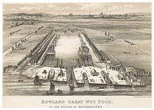
Map of RotherhitheHowlands Dock in the parish of Rotherhithe (c. 1850)A map showing the Rotherhithe wards of Bermondsey Metropolitan Borough as they appeared in 1916.
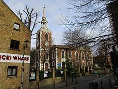
The docks were closed and largely filled in during the 1980s, and have now been replaced by modern housing and commercial facilities, but Rotherhithe retains much of its character and its maritime heritage. The largest surviving dock on the south bank, Greenland Dock, is the focal point for the southern part of the district, while there are many preserved wharves along the riverside at the north end of Rotherhithe. St. Mary's Church is at the centre of the old Rotherhithe village, which contains various historic buildings including the Brunel Engine House at the south end of the Thames Tunnel.
Canada Dock was the dock basin furthest away from the River Thames in the Surrey Docks complex, and it was linked to Albion Dock and Greenland Dock at its northern and south-eastern extremities via the Albion Canal. The dock has been remodelled, and its northwest half retained as an ornamental lake, renamed Canada Water. The canal has remained as a walkway and water feature within the redeveloped area.[9]
Southwark Council and the Greater London Authority have announced a significant regeneration project focused on Canada Water and Rotherhithe. Known as the 'Canada Water Masterplan', the project has proposed the development of an additional 3,500 homes, as well as a new high street, town square, parks, leisure centre and footpath links. The landmark Tesco store will also be relocated.[10] The project would be developed in multiple phases over the coming 15 to 20 years. Some local community groups oppose the plan based on environmental and cost considerations.[11]
The sustainable transport charity Sustrans has proposed the construction of a bicycle and pedestrian swing bridge from Rotherhithe to Canary Wharf, and cost-benefit and feasibility studies were undertaken. In January 2009 the London Mayor Boris Johnson said he would not fund the bridge, citing budget cuts due to the credit crunch,[12] with the result that the project was effectively put on ice. However the idea is still being supported by Sustrans.[13]
King's Stairs Gardens is a small park on the river towards the Bermondsey boundary. In September 2011 Thames Water announced that they wanted to build an access shaft for the "super-sewer" Thames Tideway Tunnel. Due to local action by The Save King's Stairs Gardens Campaign, which collected over 5000 signatures, Thames Water decided to build the access shaft in Chambers Wharf instead.[19]
Local landmarks and history
1895 accepted design for Rotherhithe Town Hall, view from Neptune Street and Lower Road
The Mayflower TRA Hall now occupies the site of the old Rotherhithe Town Hall.[20] The building ceased to be a town hall in 1905 when the former Rotherhithe Council merged with the old Bermondsey Borough Council and the new council used premises in Spa Road. The old Rotherhithe Town Hall became a library and a museum. It was razed to the ground by repeated bomb hits and near misses during the Second World War (see below).[21]
Rotherhithe had its own general hospital, St Olave's Hospital, on Lower Road close to the old town hall. Built originally in the early 1870s on land adjoining Rotherhithe Workhouse, it became the infirmary of St Olave's Union in 1875, and was renamed St Olave's Hospital in 1930. Subsequently, becoming part of the Guy's Hospital Teaching Group in 1966, it closed in 1985 and the site has been redeveloped into the residential Ann Moss Way.
The Terriss Theatre (named after the actor, William Terriss) opened in 1899 and was later renamed the Rotherhithe Hippodrome of Varieties. It stood on Lower Road by Culling Road. It was bombed in the 1940s and stood empty until demolition in 1955.
When the roundabout facing the Rotherhithe Tunnel was redeveloped in the early 1980s, several 19th century buildings were demolished including a school and a nunnery. A public house, the "Europa", described in an early 20th-century history of the area as one its oldest, was also demolished.
The Daily Mail and Evening Standard newspapers were printed at Harmsworth Quays in Rotherhithe from 1989 to 2012. The building became the Printworks events venue until its demolition in 2024.
Ecclesiastical parish
The Angel, a 19th-century pub in Rotherhithe now Grade II listed
The Finnish Church, Albion StreetSt Olav's, Rotherhithe's Norwegian church
Because much of the former Surrey Docks had strong trade links to Scandinavia and the Baltic region, the area is still home to a thriving Scandinavian community.[23] During World War II, in fact, it housed the Norwegian Government-in-Exile. Originally established as seafarers' missions, Rotherhithe is home to a Norwegian,[24] a Finnish[25] and a Swedish[26] church. The Finnish Church and the Norwegian Church are both in Albion Street; they were built in 1958 and 1927 respectively (Rotherhithe Library is between them). There are also a number of "community centres" for the Nordic community in London, including hostels, shops and cafés and even a sauna, mostly linked closely to the churches.
Some of the redeveloped areas were built by Nordic architects, such as the Greenland Passage development[27] by Danish Company Kjær & Richter. This gives some areas a distinctly "Nordic" feel in terms of house and street design.
The relationship with Scandinavia and the Baltic is also reflected in the names of some of the buildings (such as the King Frederik IX Tower),[27] the street names (e.g. Finland Street, Sweden Gate, Baltic Quay, Norway Gate, Helsinki Square) or other place names (e.g. Greenland Dock). Another major influence factor was trade with Russia and Canada (mainly timber), reflected in names such as Canada Water[28] and the Russia Dock Woodland.
Other connections
Rotherhithe is also a popular place to live with South Africans, according to the UK census of 2011,[29] and there was a South African themed pub at 351 Rotherhithe Street.[30]
The Mayflower
In July 1620, the Mayflower sailed from Rotherhithe and picked up 65 passengers, probably from Blackwall, then proceeded to Southampton on the south coast of England to begin loading food and supplies for the voyage to America. At that time, the English Separatists, who later became known as the "Pilgrim Fathers", were mostly still living in the city of Leiden, in the Netherlands. There they hired a ship called the Speedwell to take them from Delfshaven in the Netherlands to Southampton to join the Mayflower.[31]
The ship's master, Christopher Jones, died shortly after his return in 1621 and is buried in an unmarked grave at St Mary's Church. No one can be sure where on the Rotherhithe peninsula the Mayflower was berthed, but the Mayflower pub near St Mary's Church claims the honour, and lists the names of the Mayflower passengers on their wall. The building itself, despite external and interior appearances, dates only from the 1950s.[32] The extent to which the pub was damaged during the Second World War, and was rebuilt or simply restored, is uncertain.[33]
China Hall
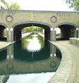
The 19th-century Surrey Lock in Rotherhithe, now a Grade II listed structure
On Lower Road, about halfway between Surrey Quays and Canada Water stations, there was a public house called the China Hall; at one time it was the entrance to a riparian playhouse visited by Samuel Pepys and mentioned in his diary. It is not known how long the theatre remained on the site, but it was reinvigorated in 1777 and George Frederick Cooke acted there the following year. In the winter of 1779, it was destroyed in fire. The site of the theatre became a well-known tea-gardens, with the "usual arbours and 'boxes'" during the Victorian period, but by the 1920s, most of the gardens had been absorbed into the Surrey Commercial Docks as part of a timber yard.[34][35]
Second World War
Like the rest of the London Docks, the Surrey Commercial Docks were targeted by the Luftwaffe. On 7 September 1940, on the first day of the London Blitz, the deal yards of Surrey Docks were set ablaze. The raid ignited over a million tonnes of timber in Quebec Yard, causing the most intense single fire ever seen in Britain.[36][37]
The bombing of the old Rotherhithe Town Hall during the Second World War gives an indication of how heavy the bombing in Rotherhithe was. The first damage to the building occurred when Luftwaffe bombs landed nearby in April 1941, and there was more bomb damage in February and June 1944. Later the same month (June 1944) the Town Hall was severely damaged by a direct hit from a V1 doodlebug. In November 1944 it was further damaged by near misses, and was finally destroyed by one of the last V1s to land on London.[38]
Several waterfront developments, such as Blenheim Court, can be seen from the Thames.
Rotherhithe is joined to the north bank of the Thames by three tunnels. The Thames tunnel to Wapping was the first underwater tunnel in the world.[40] Built by the Brunels, and originally intended to carry cross-river freight, it became a pedestrian tunnel due to the money running out to build the necessary ramps for vehicle traffic. It was used as a railway tunnel from 1869, and is now part of the London Overground network, which on 27 April 2010 started running trains on the route of the former East London Line. The later Rotherhithe Tunnel (opened 1908) carries a two-lane road to Limehouse. The Jubilee line extension (opened 1999) has a railway tunnel to Canary Wharf in the Isle of Dogs.
Parts of Rotherhithe Street were at one time or another called Jamaica Street, Lavender Street, Low Queen Street, Queen Street, Redriff Wall, Redriff, Rotherhithe Wall, Shipwright Street and Trinity Street.[7]
In 1702 Edward Swallow built a shipyard near what is now Lavender Street. John Whetstone took over in 1709, Robert Inwood in 1756 and Job Cockshott in the early 1800s, when it was divided into Lavender Dock and Lavender Wharf. In 1862 William Walker re-amalgamated the dock and wharf, but in 1870 they were separated. From 1865 John and William Walker built clippers[41] and W. Walker & Co, who had a 256ft (78m) dry dock on the Thames bank from 1869,[42] built 17 ships there between 1866 and 1882.[43] James Turner built ships there from 1873 to 1886, followed by John Medhurst until at least 1890.[41]
Rotherhithe is part of the SE16 postcode district. Electorally, the western half is Rotherhithe ward of Southwark London Borough Council and the eastern half in Surrey Docks ward.
As much of Rotherhithe was occupied by the now-defunct Surrey Commercial Docks, the district is sometimes referred to as "Surrey Docks" or (since the late 1980s) "Surrey Quays", though the latter name tends to be used more for the southern half of the peninsula. An eastern part, which became an island when the docks were in use and the locks open, is called "Downtown". This name was never related to the idea of a "downtown" in the American sense, although there was a club of that name there for many years which has now closed. This part of Rotherhithe has since the 1980s been quiet and suburban in nature. Durand's Wharf is a park in Rotherhithe Street and holds an Outdoor Gym.[44]
Notable people
Bust of the Scottish civil engineer James Walker at Greenland Dock
Max Bygraves (1922–2012), entertainer, was born in Rotherhithe.
Michael Caine (born 1933), actor, was born Maurice Joseph Micklewhite in Rotherhithe.
Thomas Coram (1668–1751) a philanthropic sea captain, retired to Rotherhithe where he campaigned for establishment of the Foundling Hospital.[45]
Eliza Fay (1755 or 1756–1816), author of Original Letters from India (1817),[46] was born in Rotherhithe.
Malcolm Hardee (1950–2005), comedian, lived on a houseboat in Greenland Dock, Rotherhithe. He owned and ran the Wibbley Wobbley pub-boat on the same dock, and was drowned there.
John Short Hewett (1781–1835) cleric and academic, was Rector of Rotherhithe between 1817 and 1835
Surrey Quays railway station is located to the south of the district. It was also an Underground station and was converted to the Overground network at the same time as Rotherhithe station. Like the other stations, it's now part of the Windrush line.
Canada Water tube station is located in central Rotherhithe. It is now an important transport interchange, as both London Overground's East London line (Now the Windrush line) and the Jubilee line of the London Underground serve it; there is also a bus station here. This station is at the centre of a major regeneration project,[48] with rapid construction of new flats.
The area is served by Transport for London bus services 1, 47, 188, 199, 225, 381, C10 and P12; night buses N1, N199 and N381 also stop here.[49]Canada Water bus station is an important stop and interchange, given its proximity to the tube station.
Walking and cycling
The riverbank carries part of the Richmond – Thames Barrier (28miles – 45km) section of the Thames Path through London. Most of the riverbank is accessible, apart from sections where warehouses and estates have established rights to the riverside.
A new bridge for pedestrians and cyclists has been proposed between Rotherhithe and Canary Wharf.
Taxis
London taxis (black cabs) can often be found on Salter Road.
↑ Wagner, Leopold (1921). A new book about London: a quaint and curious volume of forgotten lore. London: Allen & Unwin. pp.190, 191.
↑ Beck, Edward Josselyn; Bonney, Thomas George (1907). Memorials to serve for a history of the parish of St. Mary, Rotherhithe in the county of Surrey and in the administrative county of London. Cambridge University Press. pp.Appendix 259, 260.
↑ Stansky, Peter (2007). The first day of the blitz: September 7, 1940 (illustrateded.). Yale University Press. p.81. ISBN978-0-300-12556-6.
↑ Harris, Clive; Bright, Neil (2010). A Guide to Wartime London: Six Walks Revisiting the Blitz (illustrateded.). Casemate Publishers. pp.69–70. ISBN9781848841727.
This page is based on this Wikipedia article Text is available under the CC BY-SA 4.0 license; additional terms may apply. Images, videos and audio are available under their respective licenses.