
Southwark is a district of Central London situated on the south bank of the River Thames, forming the north-western part of the wider modern London Borough of Southwark. The district, which is the oldest part of South London, developed due to its position at the southern end of the early versions of London Bridge, for centuries the only dry crossing on the river. Around 43 AD, engineers of the Roman Empire found the geographic features of the south bank here suitable for the placement and construction of the first bridge.

Bermondsey is a district in southeast London, part of the London Borough of Southwark, England, 2.5 miles (4.0 km) southeast of Charing Cross. To the west of Bermondsey lies Southwark, to the east Rotherhithe and Deptford, to the south Walworth and Peckham, and to the north is Wapping across the River Thames. It lies within the historic county boundaries of Surrey. During the Industrial Revolution Bermondsey became a centre for manufacturing, particularly in relation to tanning. More recently it has experienced regeneration including warehouse conversions to flats and the provision of new transport links.
The Metropolitan Borough of Southwark was a metropolitan borough in the County of London from 1900 to 1965. It was created to cover the western section of the ancient borough of Southwark and the parish of Newington. In common with the rest of inner London, the borough experienced a steady decline in population throughout its existence. The borough council made an unsuccessful attempt to gain city status in 1955. Its former area is now the northwestern part of the current London Borough of Southwark.

Camberwell was a civil parish and metropolitan borough in south London, England. Camberwell was an ancient parish in the county of Surrey, governed by an administrative vestry from 1674. The parish was included in the area of responsibility of the Metropolitan Board of Works in 1855 and became part of the County of London in 1889. The parish of Camberwell became a metropolitan borough in 1900, following the London Government Act 1899, with the parish vestry replaced by a borough council. In 1965 the borough was abolished and its former area became part of the London Borough of Southwark in Greater London.

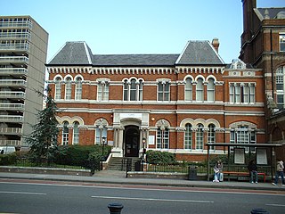
The Metropolitan Borough of Bermondsey was a Metropolitan borough in the County of London, created in 1900 by the London Government Act 1899. It was abolished and its area became part of the London Borough of Southwark in 1965.

Lambeth was a civil parish and metropolitan borough in south London, England. It was an ancient parish in the county of Surrey. The parish was included in the area of responsibility of the Metropolitan Board of Works in 1855 and became part of the County of London in 1889. The parish of Lambeth became a metropolitan borough in 1900, following the London Government Act 1899, with the parish vestry replaced by a borough council.

Battersea was a civil parish and metropolitan borough in the County of London, England. In 1965, the borough was abolished and its area combined with parts of the Metropolitan Borough of Wandsworth to form the London Borough of Wandsworth. The borough was administered from Battersea Town Hall on Lavender Hill. That building is now Battersea Arts Centre.

The River Neckinger is a reduced subterranean river that rises in Southwark and flows approximately 2.5 kilometres through that part of London to St Saviour's Dock where it enters the Thames. What remains of the river is enclosed and runs underground and most of its narrow catchment has been diverted into other combined and surface water sewers, flowing into the Southern Outfall Sewer and the Thames, respectively.
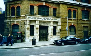
Tooley Street is a road in central and south London connecting London Bridge to St Saviour's Dock; it runs past Tower Bridge on the Southwark/Bermondsey side of the River Thames, and forms part of the A200 road.
Stoke Newington was an ancient parish in the county of Middlesex. It was both a civil parish, used for administrative purposes, and an ecclesiastical parish of the Church of England.
Bermondsey was a parish in the metropolitan area of London, England.

Southwark St George the Martyr was a civil parish in the metropolitan area of London, England and part of the ancient Borough of Southwark. In 1855 the parish vestry became a local authority within the area of responsibility of the Metropolitan Board of Works. It became part of the Metropolitan Borough of Southwark in 1900 and was abolished as a civil parish in 1930.

Southwark St Saviour was a civil parish in the metropolitan area of London, England, and part of the ancient Borough of Southwark. It was formed in 1541 from the union of the parishes of St Margaret and St Mary. It was abolished in 1930, however residents of the former parish receive a rebate against local taxation because of the presence of Borough Market. It included the Liberty of the Clink which was a special jurisdiction until 1889.
Christchurch was a civil parish in the metropolitan area of London, England. It was located south of the River Thames straddling either side of Blackfriars Road. It originated as the manor of Paris Garden in the parish of St Margaret, Southwark. The parish of St Margaret was replaced by St Saviour in 1541 and then in 1670 the area was split off as a parish in its own right when Christ Church was constructed. It was prone to flooding and was not heavily built upon until after 1809. In 1855 the parish was included in the metropolitan area of London where local government was reformed. The parish was united with St Saviour to form part of the St Saviour's District. When the district was abolished in 1900 the parish became part of the Metropolitan Borough of Southwark. It was abolished as a civil parish in 1930. The area now forms the northwestern part of the London Borough of Southwark.

St John Horsleydown was the Anglican parish church of Horsleydown in Bermondsey, South London. Built for the Commission for Building Fifty New Churches to the designs of Nicholas Hawksmoor and John James in 1726–1733, it was noted for its distinctive spire in the form of a tapering column.
St Mary Magdalen Bermondsey is an Anglican church dedicated to St Mary Magdalen in Bermondsey in the London Borough of Southwark. The majority of the present building is late 17th century and is Grade II* listed.

St Olave's Church, Southwark was a church in Southwark, England which is believed to be mentioned in the Domesday Book of 1086. It was located on Tooley Street which is named after the church, i.e. 't'olous'. It became redundant in 1926 and was demolished. It is now the location of St Olaf House, which houses part of the London Bridge Hospital.
St Olave was a local government district within the metropolitan area of London, England from 1855 to 1900. It was formed by the Metropolis Management Act 1855 and was governed by the St Olave District Board of Works, which consisted of elected vestrymen.

Southwark St Olave was an ancient civil and ecclesiastical parish on the south bank of the River Thames, covering the area around where Shard London Bridge now stands in the modern London Borough of Southwark. The boundaries varied over time but in general the parish stretched east from London Bridge past Tower Bridge to St Saviour's Dock. Southwark St Olave and St Thomas replaced the civil parish in 1896. It was abolished in 1904 and absorbed by Bermondsey parish.

The Bermondsey Lion is a sculpture in The Blue, Bermondsey, London, created by Kevin Boys for Southwark Council. It was unveiled on 16 July 2011.


