County of London

Last updated

London
County of London
County
County of London, England.svg
County of London shown within England
Area
  191174,816 acres (302.77 km2)
  196174,903 acres (303.12 km2)
Population
  19114,521,685
  19613,200,484
Density
  191160/acre
  196142/acre
History
  Origin District of the Metropolitan Board of Works
  Created1889
  Abolished1965
  Succeeded by Greater London
Status Administrative and (smaller) ceremonial county
Government London County Council
   HQ County Hall, Lambeth
Coat of Arms of London County Council.svg
Coat of arms of London County Council
Subdivisions
  Type Parishes and districts (1889–1900)
Metropolitan boroughs (1900–1965)
County of London, 1961.svg
Boroughs numbered 2–29 (1 is the City)

The County of London was a county of England from 1889 to 1965, corresponding to the area known today as Inner London. It was created as part of the general introduction of elected county government in England, by way of the Local Government Act 1888. The Act created an administrative County of London, which included within its territory the City of London. However, the City of London and the County of London formed separate ceremonial counties for "non-administrative" purposes. [1] The local authority for the county was the London County Council (LCC), which initially performed only a limited range of functions, but gained further powers during its 76-year existence. The LCC provided very few services within the City of London, where the ancient Corporation monopolised local governance. [1] In 1900, the lower-tier civil parishes and district boards were replaced with 28 new metropolitan boroughs. The territory of the county was 74,903 acres (303.12 km2) in 1961. During its existence, there was a long-term decline in population as more residents moved into the outer suburbs; there were periodic reviews of the local government structures in the greater London area and several failed attempts to expand the boundaries of the county. In 1965, the London Government Act 1963 replaced the county with the much larger Greater London administrative area.

Contents

Geography

The county occupied an area of just under 75,000 acres (30,351 ha) and lay within the London Basin. [2] It was divided into two parts (north and south) by the River Thames, which was the most significant geographical feature. It was bordered by the River Lea with Essex to the north-east, Kent to the south-east, Surrey the south-west and Middlesex to the north-west. The highest point was Hampstead Heath in the north of the county at 440 feet (134 m), which is one of the highest points in London. In 1900 a number of boundary anomalies were abolished. These included the loss of the Alexandra Park exclave to Middlesex, gaining South Hornsey in return, and the transfer of Penge to Kent.

History

Creation of the county

The Metropolis Management Act 1855 revolutionised and amalgamated much of local government across an identical, newly formed, area. This reform created an indirectly elected Metropolitan Board of Works which initially built and maintained infrastructure for the metropolis, including modern sanitation. [3] Over time the board gained more functions and became the de facto local authority and provider of new services for the London area. The board operated in those parts of the counties of Middlesex, Surrey and Kent that had been designated by the General Register Office as "the Metropolis" for the purposes of the Bills of Mortality. [3] This area had been administered separately from the City of London, which came under the control of the Corporation of London.

There had been several attempts during the 19th century to reform London government, either by expanding the City of London to cover the whole of the metropolitan area; by creating a new county of London; [4] or by creating ten municipal corporations matching the parliamentary boroughs of the metropolis. [5] These had all been defeated in Parliament, in part because of the agency power of the City Corporation. [6] Ultimately, the Local Government Act 1888 and the introduction of county councils in England provided the mechanism for creating a territory and authority encompassing the expanded London area. For expediency, the area of the metropolitan board was chosen for the new county, and no attempt was made to select new boundaries. [1] This area had been out of line with the expansion of London even in 1855. [3] For example, it anomalously omitted built-up and expanding areas such as West Ham, but included some sparsely populated areas on the metropolitan fringe. [3]

The City of London and the County of London each formed counties for "non-administrative" purposes, with a separate Lord Lieutenant and High Sheriff for the county of London. [1] However, the administrative county, which corresponded to the area of control of the county council, also included the City of London. In practice, the county council had very little authority over the ancient City, with some powers over drainage, roads, fire brigade, embankment of the river and flood prevention. [1] In common with the rest of the country, the 1888 Act provided no reform of lower-tier authorities and the county was, initially at least, administered locally by a series of parish vestries and district boards.

County council

The local authority for the county was the London County Council (LCC). Initially, the LCC provided the services it had inherited from the Metropolitan Board of Works. [1] Eventually, however, it absorbed functions from ad-hoc agencies such the London School Board and Metropolitan Asylums Board. The council was initially based in Spring Gardens, but moved to a purpose-built County Hall in the 1930s. The housing policy of the council included provision of large housing estates outside the boundaries of the county, such as that at Becontree. [7]

Local government

In 1900, eleven years after its foundation, the London Government Act divided the County of London into 28 metropolitan boroughs. These replaced the ancient parish vestries and district boards as the second tier of local government.

County of London boroughs numbered in the information box on the right side:

Metropolitan Borough

Successor(s)

No. on map

City of London City of London 1
Battersea Wandsworth 28
Bermondsey Southwark 8
Bethnal Green Tower Hamlets 6
Camberwell Southwark 10
Chelsea Kensington and Chelsea 29
Deptford Lewisham 11
Finsbury Islington 4
Fulham Hammersmith and Fulham 25
Greenwich Greenwich 14
Hackney Hackney 16
Hammersmith Hammersmith and Fulham 24
Hampstead Camden 20
Holborn Camden 3
Islington Islington 18
Kensington (Royal Borough) Kensington and Chelsea 23
Lambeth Lambeth 27
Lewisham Lewisham 12
Paddington Westminster 22
Poplar Tower Hamlets 15
Shoreditch Hackney 5
Southwark Southwark 9
St Marylebone Westminster 21
St Pancras Camden 19
Stepney Tower Hamlets 7
Stoke Newington Hackney 17
Wandsworth Lambeth, Wandsworth 26
Westminster (City) Westminster 2
Woolwich Greenwich, Newham 13

† Not a metropolitan borough.

Decline in population

Population fell after World War I and as recorded at each census until its 1965 demise. In 1901, the population was 4.5 million and by 1961 it had fallen to 3.2 million. Following the 1931 census, more of the population of "Greater London" (defined at the time as the Metropolitan Police District and City of London) lived outside the county than in it. [8] The following table illustrates the approximate population according to the census at various intervals: [9]

YearCentral Area†Inner Ring‡Second Ring§County of London
Total
Outer Ring# of
Greater London
18811,743,0001,008,0001,093,0003,844,000950,000 [10]
19011,623,0001,201,0001,601,0004,425,0001,422,000 [11]
19211,364,0001,186,0001,933,0004,483,0002,993,000 [12]
19311,260,0001,163,0001,976,0004,399,0003,807,000 [8]
1951738,000927,0001,683,0003,348,0004,998,000 [13]

†The City of London and the Metropolitan Boroughs of Bermondsey, Bethnal Green, Finsbury, Holborn, St Marylebone, St Pancras, Shoreditch, Southwark, Stepney and Westminster.

‡The Metropolitan Boroughs of Battersea, Chelsea, Islington, Kensington, Lambeth and Paddington.

§The Metropolitan Boroughs of Camberwell, Deptford, Fulham, Greenwich, Hackney, Hammersmith, Hampstead, Lewisham, Poplar, Stoke Newington, Wandsworth and Woolwich.

#Defined as the area of the Metropolitan Police district outside the County of London.

Abolition

London boroughs covering the area of the former County of London within modern Greater London Inner London (statutory).svg
London boroughs covering the area of the former County of London within modern Greater London

The county of London was abolished in 1965 and was replaced by the fivefold-sized Greater London, which took in nearly all of Middlesex, along with areas in Surrey, Kent, Essex and Hertfordshire. Middlesex and Surrey had already been reduced in 1889 on the county's creation. [14] The area "that had been" has since been known statutorily as Inner London and an Inner London Education Authority operated in the area until 1990. The 28 metropolitan boroughs were merged to form 12 new Inner London boroughs.

See also

Related Research Articles

<span class="mw-page-title-main">London boroughs</span> Administrative subdivisions of Greater London

The London boroughs are the current 32 local authority districts that together with the City of London make up the administrative area of Greater London, England; each is governed by a London borough council. The present London boroughs were all created at the same time as Greater London on 1 April 1965 by the London Government Act 1963 and are a type of local government district. Twelve were designated as Inner London boroughs and twenty as Outer London boroughs. The City of London, the historic centre, is a separate ceremonial county and sui generis local government district that functions quite differently from a London borough. However, the two counties together comprise the administrative area of Greater London as well as the London Region, all of which is also governed by the Greater London Authority, under the Mayor of London.

<span class="mw-page-title-main">London Borough of Southwark</span> London borough in United Kingdom

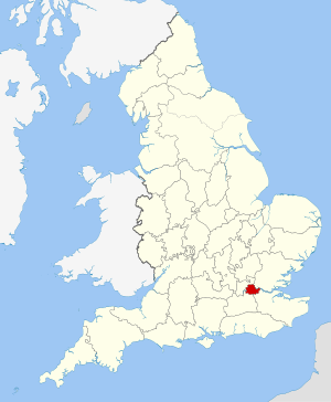
The London Borough of Southwark in South London forms part of Inner London and is connected by bridges across the River Thames to the City of London and the London Borough of Tower Hamlets. It was created in 1965 when three smaller council areas were amalgamated under the London Government Act 1963. All districts of the area are within the London postal district. It is governed by Southwark London Borough Council.

<span class="mw-page-title-main">London Borough of Lambeth</span> London borough in the United Kingdom

Lambeth is a London borough in South London, England, which forms part of Inner London. Its name was recorded in 1062 as Lambehitha and in 1255 as Lambeth. The geographical centre of London is at Frazier Street near Lambeth North tube station, though nearby Charing Cross on the other side of the Thames in the City of Westminster is traditionally considered the centre of London.

<span class="mw-page-title-main">Middlesex</span> Historic county of England

Middlesex is an area of South East England which was formerly a county; it is now mainly within the ceremonial county of Greater London, with small sections in neighbouring ceremonial counties. The county's boundaries largely followed three rivers: the Thames in the south, the Lea to the east and the Colne to the west. A line of hills formed the northern boundary with Hertfordshire. The county was the second smallest of the historic counties of England, after Rutland.

<span class="mw-page-title-main">Metropolitan Board of Works</span> Principal instrument of London-wide government from 1855 until 1889

The Metropolitan Board of Works (MBW) was the upper tier of local government for London between 1856 and 1889, primarily responsible for upgrading infrastructure. It also had a parks and open spaces committee which set aside and opened up several landmark parks. The metropolis, which the board served, included substantial parts of Middlesex, Surrey, and Kent throughout the 33 years leading up to the advent of county councils. This urban zone lay around the medieval-sized City of London but plans to enact a similar body in 1837 failed. Parliament finally passed the Metropolis Management Act 1855 which dissolved a short-lived building office and a sewers commission and made the Board effective as of December that year. The board endured until it was succeeded by London County Council, as its directly elected, direct successor, in March 1889.

<span class="mw-page-title-main">London County Council</span> English local government body (1889–1965)

The London County Council (LCC) was the principal local government body for the County of London throughout its existence from 1889 to 1965, and the first London-wide general municipal authority to be directly elected. It covered the area today known as Inner London and was replaced by the Greater London Council. The LCC was the largest, most significant and most ambitious English municipal authority of its day.

<span class="mw-page-title-main">Counties of England</span> Geographic divisions of England

The counties of England are a type of subdivision of England. Counties have been used as administrative areas in England since Anglo-Saxon times. There are three definitions of county in England: the 48 ceremonial counties used for the purposes of lieutenancy; the 84 metropolitan and non-metropolitan counties for local government; and the 39 historic counties.

<span class="mw-page-title-main">Ceremonial counties of England</span> Category of areas in England

Ceremonial counties, formally known as counties for the purposes of the lieutenancies, are areas of England to which lord-lieutenants are appointed. They are one of the two main legal definitions of the counties of England in modern usage, the other being the counties for the purposes of local government legislation. A lord-lieutenant is the monarch's representative in an area. Shrieval counties have the same boundaries and serve a similar purpose, being the areas to which high sheriffs are appointed. High sheriffs are the monarch's judicial representative in an area.

<span class="mw-page-title-main">Inner London</span> Inner boroughs of Greater London

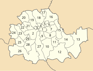
Inner London is the name for the group of London boroughs that form the interior part of Greater London and are surrounded by Outer London. With its origins in the bills of mortality, it became fixed as an area for statistics in 1847 and was used as an area of local government from 1855 to 1965 principally as the County of London or earlier as the Metropolitan Board of Works Area (metropolis). It now has two common definitions. The first is the statutory definition delineated in the London Government Act 1963, coming into force on 1 April 1965, comprising twelve Inner London boroughs and almost identical to the County of London that was abolished at the same time. The second is the definition used by the Office for National Statistics comprising eleven of the statutory Inner London boroughs and two of the statutory Outer London boroughs, as well as the City of London.

<span class="mw-page-title-main">Metropolitan Borough of St Pancras</span> Metropolitan borough of England

St Pancras was a civil parish and metropolitan borough in London, England. It was an ancient parish in the county of Middlesex, governed by an administrative vestry. The parish was included in the area of responsibility of the Metropolitan Board of Works in 1855 and became part of the County of London in 1889. The parish of St Pancras became a metropolitan borough in 1900, following the London Government Act 1899, with the parish vestry replaced by a borough council. In 1965 the borough was abolished and its former area became part of the London Borough of Camden in Greater London.

<span class="mw-page-title-main">Metropolitan Borough of Stoke Newington</span> Former London borough, United Kingdom

The Metropolitan Borough of Stoke Newington was a metropolitan borough in the County of London between 1900 and 1965 when it became part of the London Borough of Hackney.

<span class="mw-page-title-main">Metropolitan Police District</span> Police area in Police area

The Metropolitan Police District (MPD) is the police area which is policed by the Metropolitan Police Service in London. It currently consists of the ceremonial county of Greater London, which excludes the City of London. The Metropolitan Police District was created by the Metropolitan Police Act 1829 as an ad hoc area of administration because the built-up area of London spread at the time into many parishes and counties without an established boundary. The district expanded as the built up area grew and stretched some distance into rural land. When county police forces were set up in England, those of Essex, Hertfordshire, Kent and Surrey did not cover the parts of the counties within the MPD, while Middlesex did not have a county force. Similarly, boroughs in the MPD that elsewhere would have been entitled to their own police force did not have them.

<span class="mw-page-title-main">Metropolitan Water Board</span> Public utility supplying water to London 1903–1974

The Metropolitan Water Board was a municipal body formed in 1903 to manage the water supply in London, UK. The members of the board were nominated by the local authorities within its area of supply. In 1904 it took over the water supply functions from the eight private water companies which had previously supplied water to residents of London. The board oversaw a significant expansion of London's water supply infrastructure, building several new reservoirs and water treatment works.

<span class="mw-page-title-main">London Government Act 1963</span> United Kingdom legislation

The London Government Act 1963 is an act of the Parliament of the United Kingdom, which created Greater London and a new local government structure within it. The Act significantly reduced the number of local government districts in the area, resulting in local authorities responsible for larger areas and populations. The upper tier of local government was reformed to cover the whole of the Greater London area and with a more strategic role; and the split of functions between upper and lower tiers was recast. The Act classified the boroughs into inner and outer London groups. The City of London and its corporation were essentially unreformed by the legislation. Subsequent amendments to the Act have significantly amended the upper tier arrangements, with the Greater London Council abolished in 1986, and the Greater London Authority introduced in 2000. As of 2024, the London boroughs are more or less identical to those created in 1965, although with some enhanced powers over services such as waste management and education.

<span class="mw-page-title-main">London Government Act 1899</span> Act of Parliament of the United Kingdom

The London Government Act 1899 was an act of the Parliament of the United Kingdom that reformed the administration of the capital. The act divided the County of London into 28 metropolitan boroughs, replacing the 42 local authorities administering the area. The legislation also transferred a few powers from the London County Council to the boroughs, and removed a number of boundary anomalies. The first elections to the new boroughs were held on 1 November 1900.

<span class="mw-page-title-main">Metropolis Management Act 1855</span> United Kingdom legislation

The Metropolis Management Act 1855 was an act of the Parliament of the United Kingdom that created the Metropolitan Board of Works, a London-wide body to co-ordinate the construction of the city's infrastructure. The act also created a second tier of local government consisting of parish vestries and district boards of works. The Metropolitan Board of Works was the forerunner of the London County Council.

<span class="mw-page-title-main">St Giles District (Metropolis)</span>

St Giles District was a local government district in the metropolitan area of London, England from 1855 to 1900. The district was created by the Metropolis Management Act 1855, and comprised the civil parish of St Giles in the Fields and St George Bloomsbury, Middlesex: the two parishes had been combined for civil purposes in 1774. The district was abolished in 1900 and its former area became part of the Metropolitan Borough of Holborn. The civil parish was abolished in 1930. It is now part of the London Borough of Camden.

The Royal Commission on London Government, also known as the Ullswater Commission, was a Royal Commission which considered the case for amendments to the local government arrangements in the County of London and its environs. The commission was chaired by Viscount Ullswater, appointed in October 1921, and reported in 1923. The inquiry was described as an "unmitigated disaster" for proponents of reformed local government in the capital, as the commission failed to reach a unanimous decision. The majority report recommending virtually no change was signed by four commissioners, one of whom added a memorandum of dissent. Two minority reports, each signed by two commissioners, reached differing conclusions. In the event, administrative reforms were not carried out until 1965 following another inquiry.

<span class="mw-page-title-main">Administrative counties of England</span> Former subnational divisions of England

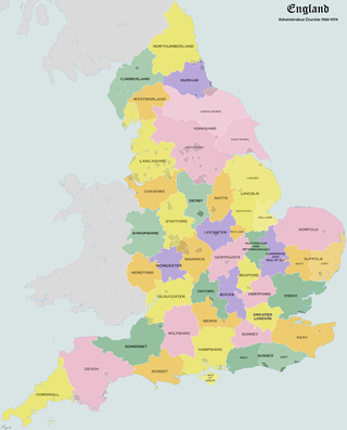
Administrative counties were subnational divisions of England used for local government from 1889 to 1974. They were created by the Local Government Act 1888, which established an elected county council for each area. Some geographically large historic counties were divided into several administrative counties, each with its own county council. The administrative counties operated until 1974, when they were replaced by a system of metropolitan and non-metropolitan counties under the Local Government Act 1972.

<span class="mw-page-title-main">Greater London</span> Metropolitan area in England

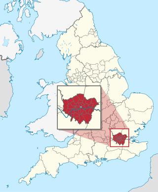
Greater London is an administrative area in England, coterminous with the London region, containing most of the continuous urban area of London. It contains 33 local government districts: the 32 London boroughs, which form a ceremonial county also called Greater London, and the City of London. The Greater London Authority is responsible for strategic local government across the region, and regular local government is the responsibility of the borough councils and the City of London Corporation. Greater London is bordered by the ceremonial counties of Hertfordshire to the north, Essex to the north-east, Kent to the south-east, Surrey to the south, and Berkshire and Buckinghamshire to the west.

References

  1. 1 2 3 4 5 6 Robson 1939, pp. 80–92.
  2. Natural England – London Basin Natural Area. Retrieved on 22 July 2009.
  3. 1 2 3 4 Robson 1939, pp. 54–61.
  4. County of London Bill, 1870
  5. Municipal Boroughs (Metropolis) Bill, 1870
  6. Robson 1939, pp. 71–79.
  7. Robson 1939, pp. 168–169.
  8. 1 2 "London census – Decline in County Population". The Times. London. 27 July 1932. p. 7.
  9. Pevsner, Nikolaus (1952). The Buildings of England – London, except the Cities of London and Westminster. Harmondsworth: Penguin. pp. 37–39.
  10. "Some Results of the Census". The Times. London. 9 June 1891.
  11. "London and the Outer Ring". The Times. London. 15 May 1901.
  12. "Official Census Figures – London's Shrinkage". The Times. London. 24 August 1921.
  13. "Census of England and Wales". The Times. 12 July 1951.
  14. Redcliffe-Maud & Wood, B., English Local Government Reformed, (1974)

Works cited

51°30′N0°06′W / 51.5°N 0.1°W / 51.5; -0.1