Staines Urban District

Last updated

Staines
Staines 1971.png
Staines within Surrey in 1971
Area
  18941,918 acres (7.8 km2)
  19748,270 acres (33.5 km2)
Population
  19016,688
  197156,725
History
  Created1894
  Abolished1974
  Succeeded by Spelthorne
Status Urban district
Government
   HQ Staines
   Motto Ad pontes prospicimus (At the bridges we look forward)
Staines Urban District Coat of Arms.jpg
Subdivisions
  Type Civil Parishes
  Units Staines Civil Parish
Ashford Civil Parish
Laleham Civil Parish
Stanwell Civil Parish

Staines was a local government district from 1894 to 1974 named after the English town of Staines.

Contents

Background, functions and boundaries

Apart from the town of Staines itself which included a few rural pockets aside from its large moor until the 1940s, the district also covered the suburban settlements of Ashford and Stanwell and Laleham. In the far north, Stanwell and Staines Moor (collectively known as Staines Moor) formed the main agricultural area at the time of disbandment of the area. During its existence a significant amount of Staines Urban District's land was transferred to the Metropolitan Water Board to form two large reservoirs and a small percentage of a third. An aqueduct and pumping station were made c. 1902 when the Staines Reservoirs were constructed across the parish boundary in Stanwell, a main cemetery, in London Road was opened in 1911 by this authority and a cottage hospital in Kingston Road in 1914. Between the two wars building spread along the London Road, where the London Transport garage was opened in 1934. The chief area of development was to the south, around the Kingston and Laleham Roads. The 'bungalow town' of what were initially simply brick-built retirement properties with gardens in South Staines or the tithing of 'Penton' towards Penton Hook was in existence by 1919. By the demise of the area many of these plots had been transformed into the two-storey houses of London commuters and affluent workers. Between the Second World War and 1964 much of the remaining land in the south of the parish was built over. Many of the houses of Staines are detached or semi-detached, with some terraces dating from the 19th century A significant planned housing and population increase took place here as in the rest of the county during the existence of its County Council.

In 1894, under the Local Government Act 1894, Staines was changed to an urban district of Middlesex. It originally just covered the parish of Staines. In 1930 the civil parishes of Ashford, Laleham and Stanwell were added from the disbanded Staines Rural District.

The Minister for Local Government and Housing considered objections from the Royal Commission on Local Government in Greater London to place 14 urban districts in Greater London and the Staines urban district was one of 8 such districts to be excluded on objection. On 1 April 1965, when Middlesex was abolished and most of its former area was transferred to Greater London under the London Government Act 1963, Staines Urban District was one of three Urban Districts transferred to Surrey or to Hertfordshire. [1]

Staines with Middlesex county in 1961 Staines1961.svg
Staines with Middlesex county in 1961

Members and programmes

At the outset 12 members convened. On the addition of the three settlements mentioned in 1930 this number doubled.

The council met fortnightly until 1897, and until its demise generally met once a month. In 1886 there were seven committees, for the town hall, commons, cemetery, highways, hospital, finance, and drainage. The provision of a sewerage system was the first major task confronting the local board, and was finally accomplished in 1896, laying main sewers through four parishes beyond to reach the major works at Twickenham which avoided acquiring costly riverside land at Staines: its importance in the council's affairs is reflected in the fact that 'general purposes' became associated in the title of the drainage committee in 1897 and the two were not divided until 1930. The hospital committee was dissolved soon after it was formed, without having provided a hospital. In 1957 the council had ten committees, and two standing sub-committees. By 1939 the urban district contained 500 council houses, of which 94 were in Staines itself. Between 1947 and 1957 a further 1,369 were built almost all in the former Rural District - two, were in Staines parish and these are described as 'sold'.

In 1896-7 the council spent nearly £8,000, and in 1955-6 nearly £624,000, of which £525,000 went to the county council and Metropolitan Police. Apart from those employed on the roads, cemeteries, and others, the original staff comprised the clerk, surveyor, and medical officer of health. By 1957 there was also a treasurer, and the four principal officers had a subordinate staff of about 100. The local firm of solicitors Horne, Engall and Freeman provided the clerks to the select vestry, local board, and council, as well as to most of the other local bodies, from 1823 to 1946, when a full-time clerk was appointed. After the World War I the town hall at an oblique angle to the river became too small for the council's offices, which were transferred to nearby buildings in Clarence Street, given up in 1952, and in Bridge Street. The surveyor's department moved to the London Road in 1950 and the clerk's department to no. 73, High Street in 1952.

A school board of five members was formed for Staines in 1885. This took over all the existing elementary schools, but did not build any new ones until 1896. Its functions were transferred to the county council in 1902. [2]

Coat of arms

The district's coat of arms was granted in 1951. It is described as: Gules on a fess barry wavy of four argent and Azure between in chief two swans respectant proper and in base a representation of London Stone Or between two seaxes (Saxon swords) blades upwards and outwards of the second hilted and pommelled a representation of the Staines Bridge Or. The crest is: On a wreath of the colours upon the battlements of a tower Or a greyhound sejeant gules. The motto is Latin for "At the bridges we look forward".

The bridge is Staines Bridge, and the waves on which it stands is the River Thames. The London Stone is the local landmark, and the swans are associated with the river. The seaxes derive from the coat of arms of Middlesex, its county.

The greyhound is from the heraldry of Mr H. Scott Freeman, who was Clerk of the Council from 1901 until 1946, and bore the cost of the grant.

Ad Pontes, part of the motto, was the Roman name for Staines. [3]

Successor

In 1974, under the Local Government Act 1972, the urban district was abolished and its former area was combined with that of Sunbury-on-Thames Urban District to form the present-day borough of Spelthorne.

Related Research Articles

<span class="mw-page-title-main">Staines-upon-Thames</span> Town in Surrey, England

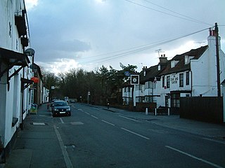
Staines-upon-Thames is a market town in northwest Surrey, England, around 17 mi (27 km) west of central London. It is in the Borough of Spelthorne, at the confluence of the River Thames and Colne. Historically part of Middlesex, the town was transferred to Surrey in 1965. Staines is close to Heathrow Airport and is linked to the national motorway network by the M25 and M3.

<span class="mw-page-title-main">Middlesex</span> Historic county of England

Middlesex is a historic county in southeast England. Its area is almost entirely within the wider urbanised area of London and mostly within the ceremonial county of Greater London, with small sections in neighbouring ceremonial counties. Three rivers provide most of the county's boundaries; the Thames in the south, the Lea to the east and the Colne to the west. A line of hills forms the northern boundary with Hertfordshire.

<span class="mw-page-title-main">Colnbrook</span> Human settlement in England

Colnbrook is a village in the Slough district in Berkshire, England. It lies within the historic boundaries of Buckinghamshire, and straddles two distributaries of the Colne, the Colne Brook and Wraysbury River. These two streams have their confluence just to the southeast of the village. Colnbrook is centred 3 miles (4.8 km) southeast of Slough town centre, 3.5 miles (5.6 km) east of Windsor, and 19 miles (31 km) west of central London.

<span class="mw-page-title-main">Borough of Spelthorne</span> Place in England

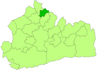
Spelthorne is a local government district and borough in Surrey, England. Its council is based in Staines-upon-Thames; other settlements in the area include Ashford, Sunbury-on-Thames, Shepperton, Stanwell and Laleham.

<span class="mw-page-title-main">Poyle</span> Human settlement in England

Poyle is a largely industrial and agricultural area in the unitary authority of Slough, in the ceremonial county of Berkshire, England. It is located 18.5 miles (30 km) west of Charing Cross in London and immediately west of the M25 motorway, near Heathrow Airport; it also adjoins the Colne Valley regional park.

<span class="mw-page-title-main">Ashford, Surrey</span> Human settlement in England

Ashford is a town almost wholly in the Borough of Spelthorne, Surrey, with a small area contained within the boundaries of the London Borough of Hounslow, approximately 14 mi (23 km) west-southwest of central London. Its name derives from a crossing point of the River Ash, a distributary of the River Colne. Historically part of Middlesex, the town's wards have been part of Surrey County Council since 1965. Ashford consists of relatively low density low- and medium-rise buildings, none of them being high rise. If excluding apartments most houses are semi-detached.

<span class="mw-page-title-main">Stanwell</span> Human settlement in England

Stanwell is a village close to two of the three main towns in the Borough of Spelthorne, Surrey, about 16 miles (26 km) west of central London. A small corner of its land is vital industrial land serving Heathrow Airport – most of the rest is residential/recreational, and the housing ranges from suburban homes with gardens to low- to mid-rise urban apartment blocks. Historically part of the county of Middlesex, it has, like the rest of Spelthorne, been in Surrey since 1965. The village is to the south of the cargo-handling area of Heathrow Airport and to the east of the Staines Reservoirs.

<span class="mw-page-title-main">Spelthorne (UK Parliament constituency)</span> Parliamentary constituency in the United Kingdom, 1918 onwards

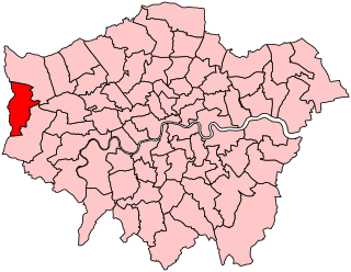
Spelthorne is a constituency in Surrey represented in the House of Commons of the UK Parliament since 2010 by Kwasi Kwarteng, a Conservative, who served as Chancellor of the Exchequer for 38 days in September and October 2022.

<span class="mw-page-title-main">Uxbridge (UK Parliament constituency)</span> Parliamentary constituency in the United Kingdom, 1885–2010

Uxbridge was a seat returning one Member of Parliament (MP) of the House of Commons of the UK Parliament from 1885 to 2010. Its MPs elected were: Conservative Party candidates for 107 years and Labour Party candidates for 18 years. The closing 40 years of the seat's history saw Conservative victory — in 1997 on a very marginal majority in relative terms.

<span class="mw-page-title-main">Municipal Borough of Willesden</span> Former district in Middlesex, England

Willesden was a local government district in the county of Middlesex, England from 1874 to 1965. It formed part of the Metropolitan Police District and London postal district. Willesden was part of the built-up area of London and bordered the County of London to the east and south.

<span class="mw-page-title-main">Municipal Borough of Ealing</span>

Ealing was a local government district from 1863 to 1965 around the town of Ealing which formed part of the built up area of London until 1965, where it became part of Greater London.

<span class="mw-page-title-main">Municipal Borough of Edmonton</span>

Edmonton was a local government district in north-east Middlesex, England, from 1850 to 1965.

<span class="mw-page-title-main">Municipal Borough of Surbiton</span> Former local government district in Surrey, England

Surbiton was a local government district in northeast Surrey, United Kingdom from 1855 to 1965.

<span class="mw-page-title-main">Potters Bar Urban District</span>

Potters Bar Urban District was a local government district in England from 1894 to 1974, covering the town of Potters Bar and the village of South Mimms. The district was initially called the South Mimms Rural District, being renamed in 1934.

<span class="mw-page-title-main">Metropolitan Water Board</span> Public utility supplying water to London 1903–1974

The Metropolitan Water Board was a municipal body formed in 1903 to manage the water supply in London, UK. The members of the board were nominated by the local authorities within its area of supply. In 1904 it took over the water supply functions from the eight private water companies which had previously supplied water to residents of London. The board oversaw a significant expansion of London's water supply infrastructure, building several new reservoirs and water treatment works.

<span class="mw-page-title-main">Municipal Borough of Heston and Isleworth</span>

Heston and Isleworth was a local government district of Middlesex, England from 1894 to 1965.

<span class="mw-page-title-main">Sunbury-on-Thames Urban District</span>

Sunbury on Thames Urban District, also known as Sunbury Urban District, was a local government district from 1894 to 1974 comprising the town and parish of Sunbury-on-Thames and from 1930 also the parishes of Littleton and Shepperton.

<span class="mw-page-title-main">Staines Rural District</span>

Staines Rural District was a rural district of Middlesex in England from 1894 to 1930.

<span class="mw-page-title-main">History of Staines-upon-Thames</span>

History of Staines-upon-Thames in the historic county of Middlesex and Surrey County Council, England

<span class="mw-page-title-main">Penton Hook Lock</span> Lock on the River Thames in Surrey, England

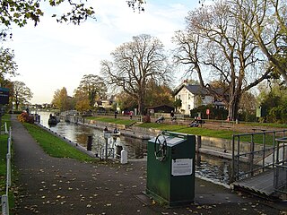
Penton Hook Lock is the sixth lowest lock of forty four on the non-tidal reaches of the River Thames in England. It faces an island which was until its construction a pronounced meander and is on the site of its seasonal cutoff. It is against the left bank marking the church parish medieval border of Laleham and Staines upon Thames in Surrey for many centuries. Until 1965 their county was Middlesex. At 266 ft (81 m) it is the third longest lock on the river.

References

  1. Susan Reynolds, ed. (1962). "Staines: Introduction". A History of the County of Middlesex: Volume 3. Institute of Historical Research. Retrieved 27 October 2014.
  2. Susan Reynolds, ed. (1962). "Staines: Local government". A History of the County of Middlesex: Volume 3. Institute of Historical Research. Retrieved 27 October 2014.
  3. "Staines". Heraldry of the World. Retrieved 29 December 2016.

Coordinates: 51°26′N0°31′W / 51.44°N 0.51°W / 51.44; -0.51