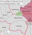
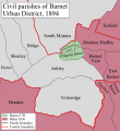
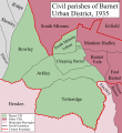
Barnet | |
---|---|
Local Government District (1863–1894) Urban District (1894–1965) | |
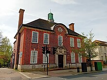
![]() Council's offices, now the North London Coroner's Court | |
Area | |
• 1911 | 1,510 acres (6.1 km2) [1] |
• 1931 | 3,114 acres (12.6 km2) [1] |
• 1961 | 4,290 acres (17.4 km2) [1] |
Population | |
• 1911 | 10,440 [1] |
• 1931 | 14,726 [1] |
• 1961 | 27,846 [1] |
Density | |
• 1911 | 6.9/acre |
• 1931 | 4.7/acre |
• 1961 | 6.5/acre |
History | |
• Created | 5 October 1863 |
• Abolished | 31 March 1965 |
• Succeeded by | London Borough of Barnet |
Government | Barnet Local Board (1863-1894) Barnet Urban District Council (1894-1965) |
• HQ | 29 Wood Street, Barnet |
Barnet was a local government district in south Hertfordshire from 1863 to 1965 around the town of Barnet.
Barnet Local Government District was created on 5 October 1863, after the town's ratepayers decided to adopt the Local Government Act 1858, and it was governed by a local board. [2] Under the Public Health Act 1872 local government districts were also designated as urban sanitary districts. The Local Government Act 1894 (56 & 57 Vict. c. 73) reconstituted the area as an urban district with effect from 31 December 1894, and the local board was replaced by an elected Barnet Urban District Council. [3] The urban district was extended in 1905, 1914 and 1935. [4]
The district originally consisted of parts of the parishes of Chipping Barnet in Hertfordshire, and Monken Hadley and South Mimms in Middlesex. The Local Government Act 1888 adjusted the county boundaries in 1889, so that the entire district was in Hertfordshire; forming part of a long, thin protrusion into Middlesex surrounded by that county on two sides, to the north and south.
The Local Government Act 1894 (56 & 57 Vict. c. 73) divided the urban district into three civil parishes:
On 30 September 1896 the parish of South Mimms Urban (and therefore Barnet Urban District) was enlarged, gaining area previously in the parish of South Mimms (South Mimms Rural District). [5] On 25 June the following year the parish of Chipping Barnet was also enlarged, gaining area previously in the parish of Arkley (Barnet Rural District). [6]
In 1905 and 1914 respectively the parishes of Arkley and Totteridge were added, from Barnet Rural District. Rowley parish was added on 1 April 1935, created from area of the parishes of Elstree, Ridge and Shenley that lay east of the A1 in the Barnet Rural District. [4]
Barnet Urban District was abolished by the London Government Act 1963 and its former area transferred from Hertfordshire to Greater London on 1 April 1965. Its former area was combined with that of other districts to form the present-day London Borough of Barnet.
The urban district was divided into six wards for elections: Arkley East, Arkley West, Barnet North, Barnet South, Totteridge East and Totteridge West.
For elections to Parliament, the urban district was part of the constituency of:
In 1945 St Albans was divided as an emergency measure because its electorate exceeded 100,000 voters, with the urban district becoming part of the new constituency of:
Totteridge is a residential area and former village in the London Borough of Barnet, England. It is a mixture of suburban development and open land situated 8 miles (13 km) north north-west of Charing Cross. It is part of the Whetstone postal district (N20).
The London Borough of Barnet is a local authority area on the northern outskirts of London. The borough was formed in 1965 from parts of the ceremonial counties of Middlesex and Hertfordshire. It is the second largest London borough by population with 389,344 inhabitants as of 2021, also making it the 17th largest district in England. The borough covers an area of 86.74 square kilometres (33 sq mi), the fourth highest of the 32 London boroughs, and has a population density of 45.8 people per hectare, which ranks it 25th.
Chipping Barnet or High Barnet is a suburban market town in north London, forming part of the London Borough of Barnet, England. It is a suburban development built around a 12th-century settlement, and is located 10+1⁄2 miles (17 km) north-northwest of Charing Cross, 3 miles (4.8 km) east from Borehamwood, 5.2 miles (8.4 km) west from Enfield and 3.2 miles (5.1 km) south from Potters Bar. Its population, including its localities East Barnet, New Barnet, Hadley Wood, Monken Hadley, Cockfosters and Arkley, was 47,359 in 2011.
New Barnet is a neighbourhood on the north east side of the London Borough of Barnet. It is a largely residential North London suburb located east of Chipping Barnet, west of Cockfosters, south of the village of Monken Hadley and north of Oakleigh Park.
The Diocese of St Albans forms part of the Province of Canterbury in England and is part of the wider Church of England, in turn part of the worldwide Anglican Communion.
East Barnet Valley was a local government district from 1874 to 1965 around the town of East Barnet. It was partly in the counties of Hertfordshire and Middlesex until 1889, when the Middlesex part was transferred to Hertfordshire. It was renamed East Barnet in 1935.
Friern Barnet Urban District was a local government area in Middlesex, England created in 1883 from the civil parish Friern Barnet. It was succeeded by the London Borough of Barnet in 1965 as one of the smaller of its contributory predecessor districts. It was at the local level governed for nine years by the local board, then by Friern Barnet Urban District Council which operated primarily with separate functions from the County Council, operating occasionally for major planning decisions and major projects together with that body, Middlesex County Council.
Potters Bar Urban District was a local government district in England from 1894 to 1974, covering the town of Potters Bar and the village of South Mimms. The district was initially called the South Mimms Rural District, being renamed in 1934.
Monken Hadley is a place in the London Borough of Barnet. An ancient country village north of Barnet, it is now a suburban development on the very edge of Greater London 11 miles (18 km) north north-west of Charing Cross, while retaining much of its rural character.
The London Borough of Barnet, located on the northern periphery of London and having much of the area within its boundaries in the Metropolitan Green Belt, has many parks and open spaces. In addition there are large areas taken over by cemeteries and golf courses, and part of Hampstead Heath.
Elstree and Borehamwood is a civil parish in the Hertsmere district, in Hertfordshire, England. Located approximately 12 miles (19 km) northwest of central London and adjacent to the Greater London boundary, it is an urbanised parish with suburban residential development, some open land and light industry. Elstree and Borehamwood is a recent renaming of the ancient parish of Elstree, covering the settlements of Elstree and Borehamwood. Formed in 1894 as the Elstree Parish Council, the local council is Elstree and Borehamwood Town Council. One of the most populous civil parishes in England, at the 2021 census it had a population of 41,423.
Elstree Rural District was a rural district in Hertfordshire, England from 1894 to 1974.
Hadley Wood is suburb of north London, close to the border with Hertfordshire. It is part of the London Borough of Enfield, 11 miles (17.7 km) north of Charing Cross, close to Chipping Barnet.
The Liberty of St Albans was a liberty situated within Hertfordshire, but enjoying the powers of an independent county. It was originally associated with the abbey of St Albans, and later with the borough corporation. It was absorbed by Hertfordshire in 1874. It was also known as the Hundred of Cashio.
Enfield was a constituency for the House of Commons of the UK Parliament from 1885 until 1950. The area sloping to the River Lea in the east was in the far north of Middlesex centred on the town of Enfield. The area formed part of the London conurbation and was much reduced over the course of its existence, in 1918 and then insignificantly in 1945 due to suburbanisation and urbanisation. It returned one Member of Parliament (MP).
Edmonton is one of six hundreds of the historic county of Middlesex, England. A rotated L-shape, its area has been in the south and east firmly part of the urban growth of London. Since the 1965 formation of London boroughs it mainly corresponds to the London Boroughs of Enfield, a negligible portion of Barnet and a narrow majority of Haringey. Its ancient parish of South Mimms has since 1965 been part of the Hertsmere district in Hertfordshire.
The History of local government districts in Middlesex outside the metropolitan area began in 1835 with the formation of poor law unions. This was followed by the creation of various forms of local government body to administer the rapidly growing towns of the area. By 1934 until its abolition in 1965, the entire county was divided into urban districts or municipal boroughs.
Arkley is a village in Greater London, England, within the London Borough of Barnet. It is located 10.6 miles (17.1 km) north-northwest of Charing Cross.
Frederick Charles Cass (1824-1896) was the rector of the parish of Monken Hadley in north London. His father, also Frederick Cass, owned the relevant advowson giving the right to make such appointments. He was the author of works of local history relating to South Mimms, Monken Hadley and East Barnet.
Great Britain Historical GIS / University of Portsmouth, Barnet UD ( historic map ). Retrieved 28 January 2008.