Municipal Borough of Wood Green

Last updated

Wood Green
Woodside House (2832255621).jpg
The former Wood Green Town Hall
Woodgreen1961.svg
Wood Green within Middlesex in 1961
Area
  19011,625 acres (6.6 km2)
  19651,697 acres (6.9 km2)
Population
  190134,223
  196147,945
History
  Created1888
  Abolished1965
  Succeeded by London Borough of Haringey
Status Local board (1888–1894)
Civil parish (1894–1965)
Urban district (1894–1933)
Municipal borough (1933–1965)
Government
   HQ Woodside House, Wood Green
   Motto Nostrum Viret Robur
Woodgreen arms.png
Coat of arms of the municipal borough council

Wood Green was a local government district in south east Middlesex from 1888 to 1965.

Contents

History

Until 1888, Wood Green was part of Tottenham, and was included in the district of the Tottenham Local Board in 1850. Pressure from residents of the area led to the passing of the Tottenham Local Board (Division of District) Act 1888, constituting a separate local board for the area. [1]

In 1894, under the local Government Act of that year, Wood Green became an urban district. In 1933 it was incorporated as a municipal borough. It was part of the London postal district and Metropolitan Police District.

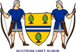
A coat of arms was granted to the borough on incorporation. The shield featured yew trees and was supported by medieval archers, recalling that Wood Green had once been an area where archery was practised. A silver and blue stripe across the centre of the shield depicted the New River. The Latin motto was nostrum viret robur, which could be translated as our strength is a tree or more appropriately as Wood Green Flourishes. [2]

In 1893, Earlham Grove House (later known as Woodside House) was purchased by the Local Board to serve as a Town Hall. It accommodated the area's first public library, and in 1913 a single-storey extension was added to provide a council chamber for meetings of the Urban District Council. The building continued in use as Wood Green Town Hall until 1958. [3]

In 1965, the municipal borough was abolished and its area was transferred to Greater London under the London Government Act 1963. Wood Green's area was combined with the Municipal Borough of Tottenham and the Municipal Borough of Hornsey to form the present-day London Borough of Haringey. [4]

Related Research Articles

Wood Green District in England

Wood Green is a suburban district in the borough of Haringey in London, England. Its postal district is N22, with parts in N8 or N15. The London Plan identifies it as one of the metropolitan centres in Greater London, and today it forms a major commercial district of North London.

London Borough of Haringey London borough in United Kingdom

The London Borough of Haringey is a London borough in North London, classified by some definitions as part of Inner London, and by others as part of Outer London. It was created in 1965 by the amalgamation of three former boroughs. It shares borders with six other London boroughs. Clockwise from the north, they are: Enfield, Waltham Forest, Hackney, Islington, Camden, and Barnet.

Middlesex Historic county of England

Middlesex is a historic county in southeast England. Its area is almost entirely within the wider urbanised area of London and mostly within the ceremonial county of Greater London, with small sections in neighbouring ceremonial counties. Three rivers provide most of the county's boundaries; the Thames in the south, the Lea to the east and the Colne to the west. A line of hills forms the northern boundary with Hertfordshire.

Seven Sisters is a sub-district of Tottenham, north London in the United Kingdom, formerly within the municipal borough of Tottenham, which on 1 April 1965 was subsumed into the new London Borough of Haringey. It is located at the eastern end of Seven Sisters Road, which runs from Tottenham High Road to join the A1 in Holloway. It is within the South Tottenham postal district.

County Borough of Croydon

The County Borough of Croydon was a local government district in and around the town of Croydon in north east Surrey, England from 1889 to 1965. Since 1965 the district has been part of the London Borough of Croydon within Greater London.

Municipal Borough of Finchley

Finchley, which is now in north London, was a local government district in Middlesex, England, from 1878 to 1965. Finchley Local Board first met in 1878. It became Finchley District Council in 1895 and the Municipal Borough of Finchley in 1933. In 1965 Middlesex was abolished and Finchley became part of the London Borough of Barnet.

Municipal Borough of Beckenham

Beckenham was a local government district in north west Kent from 1878 to 1965 around the town of Beckenham. The area was suburban to London, formed part of the Metropolitan Police District and from 1933 was included in the area of the London Passenger Transport Board.

Municipal Borough of Hornsey

The Municipal Borough of Hornsey was a local government district in east Middlesex from 1867 to 1965.

Municipal Borough of Tottenham

Tottenham was a local government district in north east Middlesex from 1850 to 1965. It was part of the London postal district and Metropolitan Police District.

Municipal Borough of Acton

Acton was a local government district in Middlesex, England from 1865 to 1965.

Municipal Borough of Southall

Southall was a local government district in the county of Middlesex, United Kingdom from 1891 to 1965. It consisted of the civil parish of Norwood.

Municipal Borough of Enfield

Enfield was a local government district in Middlesex, England from 1850 to 1965.

Municipal Borough of Southgate

Southgate was a local government district of Middlesex from 1881 to 1965. It was part of the London postal district and Metropolitan Police District.

Municipal Borough of Twickenham

Twickenham was a local government district in Middlesex, England from 1868 to 1965.

The London Government Act 1963 is an Act of the Parliament of the United Kingdom, which created Greater London and a new local government structure within it. The Act significantly reduced the number of local government districts in the area, resulting in local authorities responsible for larger areas and populations. The upper tier of local government was reformed to cover the whole of the Greater London area and with a more strategic role; and the split of functions between upper and lower tiers was recast. The Act classified the boroughs into inner and outer London groups. The City of London and its corporation were essentially unreformed by the legislation. Subsequent amendments to the Act have significantly amended the upper tier arrangements, with the Greater London Council abolished in 1986, and the Greater London Authority introduced in 2000. As of 2016, the London boroughs are more or less identical to those created in 1965, although with some enhanced powers over services such as waste management and education.

Hornsey was an ancient parish in the county of Middlesex. It was both a civil parish, used for administrative purposes, and an ecclesiastical parish of the Church of England.

Woodside High School, Wood Green Academy in Wood Green, London, England

Woodside High School is a mixed 11–16 comprehensive school located in the Wood Green area of the London Borough of Haringey, England. With a student roll of 1200, the school has been judged by Ofsted as outstanding for two consecutive inspections.

Edmonton Hundred

Edmonton is one of six hundreds of the historic county of Middlesex, England. A rotated L-shape, its area has been in the south and east firmly part of the urban growth of London. Since the 1965 formation of London boroughs it mainly corresponds to the London Boroughs of Enfield, a negligible portion of Barnet and a narrow majority of Haringey. Its ancient parish of South Mimms has since 1965 been part of the Hertsmere district in Hertfordshire.

Tottenham Human settlement in England

Tottenham is a town in north London, England, within the London Borough of Haringey. It is located in the ceremonial county of Greater London and the historic county of Middlesex. Tottenham is centred 6 miles (10 km) north-northeast of Charing Cross, bordering Edmonton to the north, Walthamstow, across the River Lea, to the east, and Stamford Hill to the south, with Wood Green and Harringay to the west.

George Meehan House Municipal building in London, England

George Meehan House is a municipal building in High Road, Wood Green, London. It is surrounded by a public park known as Woodside Park and is a locally listed building.

References

  1. 51 & 52 Vict. c. 187
  2. Letters Patent dated August 1, 1933
  3. "The History of George Meehan House (formerly Woodside House)". Haringey Council. Retrieved 15 October 2019.
  4. "Local Government Act 1963". Legislation.gov.uk. Retrieved 25 April 2020.

Coordinates: 51°36′N0°7′W / 51.600°N 0.117°W / 51.600; -0.117