Metropolitan Borough of Greenwich

Last updated

Greenwich
West Greenwich Community Centre - geograph.org.uk - 1464283.jpg
The former Greenwich Town Hall (until 1939)
Metropolitan Borough of Greenwich.svg
Greenwich within the County of London
History
  Created1900
  Abolished1965
  Succeeded by Royal Borough of Greenwich
Status Metropolitan borough
GovernmentGreenwich Borough Council
   HQ Town Hall, Greenwich High Road (until 1939); new Town Hall (from 1939)
   Motto Tempore Utimur (We make use of time)
Greenwich arms.png
Metropolitan Borough of Greenwich Map of borough boundary

The Metropolitan Borough of Greenwich was a metropolitan borough in the County of London between 1900 and 1965. It bordered the boroughs of Woolwich, Lewisham and Deptford and, across the River Thames, the borough of Poplar and the County Borough of West Ham in Essex. Within the area of the borough were the Royal Naval College (now the National Maritime Museum), the Royal Observatory and Greenwich Park.

Contents

The borough was abolished in 1965, and its area was merged with that of the borough of Woolwich to form the London Borough of Greenwich within the new ceremonial county of Greater London.

Formation and boundaries

The borough was formed from four civil parishes: Charlton-next-Woolwich, Deptford St Nicholas, Greenwich and Kidbrooke. In 1901 Charlton-next-Woolwich and Kidbrooke were merged to form Charlton and Kidbrooke. [1] In 1930 the remaining three civil parishes were combined into a single civil parish called Borough of Greenwich, which was conterminous with the metropolitan borough. [2]

Previous to the borough's formation it had been administered by two separate local bodies: Greenwich District Board of Works and Lee District Board of Works. [3]

Population and area

The borough covered 3,852 acres (15.6 km2). The population in each decennial census was:

Constituent parishes 1801–1899

Year [4] 1801181118211831184118511861187118811891
Population22,07725,30328,74833,37439,80047,37757,41756,45065,41178,167

Metropolitan Borough 1900–1961

Year1901191119211931194119511961
Population95,78095,968100,450100,924 [5] 89,84685,546

Politics

A map showing the wards of Greenwich Metropolitan Borough as they appeared in 1916. Greenwich Met. B Ward Map 1916.svg
A map showing the wards of Greenwich Metropolitan Borough as they appeared in 1916.

The borough was divided into eight wards for elections: Charlton & Kidbrooke, Marsh, North West, North, South East, South, St Nicholas Deptford and West. [6] [7]

Borough council

Metropolitan borough councils elections were held triennially. The first election to the borough council was held on 1 November 1900. The result was a majority for the pro-Conservative Moderates, who had 16 councillors elected. The opposition was formed by the Progressives with 8 seats. [8] At the next election in 1903 Moderates held control with the support of 2 Independent Conservative councillors. [9] By the time of the 1906 election, the Conservatives contested the elections throughout London under the Municipal Reform label. The Municipal Reformers held the council with 21 seats to 5 Progressives and 4 Independents. [10] They held the council at the 1909 and 1912 elections: 1909 saw the first Socialist councillor elected to the council. [11] Due to World War I, the next council election was not held until 1919. The Labour Party took control of the borough, with 20 seats to 10 for the Municipal Reform Party. [12] Three years later the position was reversed, with Municipal Reformers retaking control with 22 seats to Labour's 11. [13] At the 1925 election the Municipal Reform and Labour parties both took 15 seats, and the borough council was consequently under no overall control. [14] The same party composition was returned at the 1928 and 1931 elections. [15] Labour subsequently gained control, which they held at the 1934 election. [16] Labour held the borough at the 1937 election. [17] Elections were again suspended during the Second World War, the next contest being in 1945: Labour held the borough. [18] Elections to boroughs due in November 1948 were postponed to May 1949 to coincide with those for county councils. The Conservative Party contested the elections in the place of the Municipal Reformers. Labour held the council at this and all later elections to the metropolitan borough council, with the Conservatives forming the only other grouping. [19] The last election to the council was held on 10 May 1962, when Labour gained 29 seats to 6 for the Conservatives. [20]

Parliamentary constituency

A parliamentary borough of Greenwich had been formed by the Reform Act 1832. In 1918 the boundaries were realigned to correspond to the metropolitan borough.

Coat of arms

The borough council was granted a coat of arms by the College of Arms on 15 July 1903. The central band bearing an hour-glass represented the Greenwich Meridian and the surrounding stars the Royal Observatory. The crest above the shield was an ancient ship and crossed anchors, standing for the connections of Greenwich with the Royal Navy. The Latin motto was Tempore utimur or "We use time": a reference to Greenwich Mean Time. [21]

Some charges from these arms were taken over for the arms of the London Borough of Greenwich in 1965 and in 2012 for the new coat of arms of the Royal Borough of Greenwich.

Town Halls

West Greenwich House was built in 1876 and served as headquarters for the Greenwich District Board of Works before it was inherited by the new Borough Council in 1900. When built it had a dome and lantern above the parapet. It served as the Town Hall until 1939 after which it housed other council offices. Today it thrives as the West Greenwich Community and Arts Centre; the building was recently restored and refurbished. [22]

The 1939 Town Hall, further east from the 1876 building. Meridian House (Former Greenwich Town Hall).jpg
The 1939 Town Hall, further east from the 1876 building.

In 1939, a new and much larger Greenwich Town Hall and Borough Hall were built on the corner of Greenwich High Road and Royal Hill in the Art Deco style. When the Metropolitan Borough of Greenwich was merged into the London Borough of Greenwich in the 1960s, Woolwich Town Hall was used as the headquarters for the new larger borough instead. The Town Hall and Borough Hall buildings are now occupied by GSM London and a dance centre (Greenwich Dance) respectively. [23]

Related Research Articles

<span class="mw-page-title-main">Royal Borough of Greenwich</span> Place in United Kingdom

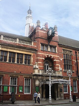
The Royal Borough of Greenwich is a London borough in southeast Greater London, England. The London Borough of Greenwich was formed in 1965 by the London Government Act 1963. The new borough covered the former area of the Metropolitan Borough of Greenwich and part of the Metropolitan Borough of Woolwich to the east. The local council is Greenwich London Borough Council which meets in Woolwich Town Hall. The council's offices are also based in Woolwich, the main urban centre in the borough.

<span class="mw-page-title-main">Metropolitan Borough of Bermondsey</span>

The Metropolitan Borough of Bermondsey was a Metropolitan borough in the County of London, created in 1900 by the London Government Act 1899. It was abolished and its area became part of the London Borough of Southwark in 1965.

<span class="mw-page-title-main">Charlton, London</span> Human settlement in England

Charlton is an area of southeast London, England, in the Royal Borough of Greenwich. It is east of Greenwich and west of Woolwich, on the south bank of the River Thames, 7.2 miles (11.6 km) southeast of Charing Cross. An ancient parish in the county of Kent, it became part of the metropolitan area of London in 1855 and is home to Charlton Athletic F.C. and Charlton House.

<span class="mw-page-title-main">Metropolitan Borough of Finsbury</span>

The Metropolitan Borough of Finsbury was a metropolitan borough within the County of London from 1900 to 1965, when it was amalgamated with the Metropolitan Borough of Islington to form the London Borough of Islington.

<span class="mw-page-title-main">Metropolitan Borough of Hackney</span>

The Metropolitan Borough of Hackney was a metropolitan borough of the County of London from 1900 to 1965. Its area became part of the London Borough of Hackney.

<span class="mw-page-title-main">Metropolitan Borough of Stoke Newington</span>

The Metropolitan Borough of Stoke Newington was a metropolitan borough in the County of London between 1900 and 1965 when it became part of the London Borough of Hackney.

<span class="mw-page-title-main">Eltham (UK Parliament constituency)</span> UK Parliament constituency since 1983

Eltham is a constituency created in 1983 and represented in the House of Commons of the UK Parliament since 1997 by Clive Efford of the Labour Party.

<span class="mw-page-title-main">Greenwich and Woolwich (UK Parliament constituency)</span> Parliamentary constituency in the United Kingdom, 1997 onwards

Greenwich and Woolwich is a constituency represented in the House of Commons of the UK Parliament since 2015 by Matthew Pennycook of the Labour Party.

<span class="mw-page-title-main">Parliamentary constituencies in London</span>

The region of Greater London, including the City of London, is divided into 73 parliamentary constituencies which are sub-classified as borough constituencies, affecting the type of electoral officer and level of expenses permitted.

<span class="mw-page-title-main">Greenwich (UK Parliament constituency)</span> Parliamentary constituency in the United Kingdom, 1885–1997

Greenwich was a constituency in south-east London, which returned at first two, then one member (MP) to the House of Commons of the UK Parliament. It existed from 1832 to 1997. Elections used the first past the post system; when this elects more than one member, it is sometimes called plurality-at-large voting.

<span class="mw-page-title-main">County Borough of East Ham</span>

East Ham was a local government district in the far south west of Essex from 1878 to 1965. It extended from Wanstead Flats in the north to the River Thames in the south and from Green Street in the west to Barking Creek in the east. It was part of the London postal district and Metropolitan Police District.

<span class="mw-page-title-main">County Borough of West Ham</span> Historical local government district in the extreme south west of Essex

West Ham was a local government district in the extreme south west of Essex from 1886 to 1965, forming part of the built-up area of London, although outside the County of London. It was immediately north of the River Thames and east of the River Lea.

<span class="mw-page-title-main">Municipal Borough of Beddington and Wallington</span>

Beddington and Wallington was, from 1915 to 1965, a local government district in north east Surrey, England. It formed part of the London suburbs, lying within the Metropolitan Police District and the London Passenger Transport Area. In 1965 it was abolished on the creation of Greater London.

The Municipal Reform Party was a local party allied to the parliamentary Conservative Party in the County of London. The party contested elections to both the London County Council and metropolitan borough councils of the county from 1906 to 1945.

<span class="mw-page-title-main">Hundred of Blackheath, Kent</span>

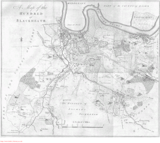
Blackheath was an ancient hundred in the north west of the county of Kent in England. It had become obsolete by the beginning of the 20th century in the wake of ongoing reforms to local government. The name "Blackheath" now refers to a district of SE London. In 2022, the area of the old hundred lies mainly within the Royal Borough of Greenwich.

<span class="mw-page-title-main">George Hume (politician)</span>

Sir George Hopwood Hume was a British Conservative politician and leader of the London County Council.

Plumstead (1855–1894) and then Lee (1894–1900) was a local government district within the metropolitan area of London from 1855 to 1900. It was formed as the Plumstead district by the Metropolis Management Act 1855 and was governed by the Plumstead District Board of Works, which consisted of elected vestrymen.

<span class="mw-page-title-main">Lewisham London Borough Council</span>

Lewisham London Borough Council is the local authority for the London Borough of Lewisham in Greater London, England. It is a London borough council, one of 32 in the United Kingdom capital of London. The council is unusual in that its executive function is controlled by a directly elected mayor of Lewisham, currently Damien Egan. Lewisham is divided into 19 wards, each electing two or three councillors. There are currently 16 three member wards and 3 two member wards. Following the May 2018 election, Lewisham London Borough Council comprises 54 Labour Party councillors. The council was created by the London Government Act 1963 and replaced two local authorities: Deptford Metropolitan Borough Council and Lewisham Metropolitan Borough Council.

The 1964 Greenwich Council election took place on 7 May 1964 to elect members of Greenwich London Borough Council in London, England. The whole council was up for election and the Labour party gained control of the council.

<span class="mw-page-title-main">1937 London County Council election</span> 1937 local election in England

An election to the County Council of London took place on 4 March 1937. The council was elected by First Past the Post with each elector having two votes in the two-member seats. The Labour Party made gains, increasing their majority over the Municipal Reform Party.

References

  1. "GB Historical GIS / University of Portsmouth, Charlton and Kidbrooke CP through time: Census tables with data for the Parish-level Unit". A Vision of Britain through Time. Retrieved 19 February 2015.
  2. "GB Historical GIS / University of Portsmouth, Borough of Greenwich CP through time: Census tables with data for the Parish-level Unit". A Vision of Britain through Time. Retrieved 19 February 2015.
  3. F A Youngs, Guide to the Local Administrative Units of England, Vol.I, London, 1979
  4. Statistical Abstract for London, 1901 (Vol. IV); Vision of Britain website
  5. The census was suspended for World War II
  6. Post Office London County Suburbs Directory, 1919. 1919. Retrieved 18 February 2015.
  7. Ordnance Survey 'County Series 3rd Edition' Map of London (1912–14) at 1:2500 scale. Accessed at https://www.old-maps.co.uk/
  8. The London borough elections, The Times, 3 November 1900
  9. London borough council elections, The Times 4 November 1903
  10. London borough council elections, The Times, 3 November 1906
  11. London borough council elections, The Times 3 November 1909; The London borough elections, The Times, 4 November 1912
  12. Borough council elections – Extensive Labour gains, The Times, 4 November 1919
  13. Labour rout in London, The Times, 3 November 1922
  14. The borough elections, a slight Labour advance, 4 November, The Times, 1925
  15. The municipal elections, The Times, 3 November 1928; The borough elections – Labour routed, The Times, 4 November 1931
  16. The municipal elections – more Labour gains in London, The Times, 3 November 1934
  17. The new London councils – state of parties, The Times, 3 November 1937
  18. The Municipal Elections – Results in London Boroughs, The Times, 3 November 1945
  19. The municipal elections, Changes in London boroughs, The Times, 9 May 1953; Labour gains in London poll, The Times, 12 May 1956; Borough elections – London results, The Times, 9 May 1959
  20. Election results in the boroughs, The Times, 11 May 1962
  21. A C Fox-Davies, The Book of Public Arms, 2nd edition, 1915; C W Scott-Giles, Civic Heraldry of England and Wales, 2nd edition 1953
  22. "About us". Greenwich West. Retrieved 24 April 2020.
  23. "Greenwich Town Hall". Manchester History. Retrieved 24 April 2020.

Further reading

51°29′N0°01′E / 51.48°N 0.02°E / 51.48; 0.02