Municipal Borough of Wanstead and Woodford

Last updated

Wanstead and Woodford
Wanstead and woodford essex 1961.png
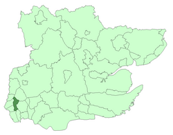
Wanstead and Woodford within Essex in 1961
Area
  19343,842 acres (15.5 km2)
  19653,864 acres (15.6 km2)
Population
  193944,057
  196161,416
History
  Created1934
  Abolished1965
  Succeeded by London Borough of Redbridge
Status Urban district (until 1937)
Municipal borough (after 1937)
Coat of Arms of the Municipal Borough of Wanstead and Woodford.svg
Coat of Arms [1]

Wanstead and Woodford was a local government district from 1934 to 1965 in southwest Essex, England. A merger of two former urban districts, it was suburban to London and part of the Metropolitan Police District.

Contents

Background

A local board of health was set up for the parish of Wanstead in 1854. The Local Government Act 1894 reconstituted its area as Wanstead Urban District, governed by Wanstead Urban District Council. [2]

Woodford parish adopted the Local Government Act 1858 in 1873, setting up a local board. In 1894 it became Woodford Urban District, governed by Woodford Urban District Council. [3]

In 1934, as part of a county review order, a new urban district was created as a merger of their areas. [4]

District and borough

The urban district was incorporated as a municipal borough in 1937. [4] The charter was presented by the Prince Henry, Duke of Gloucester on 14 October of that year while the ceremonial mace was presented by Winston Churchill, Member of Parliament for the area. [5]

In 1956 the municipal borough was enlarged by gaining 23 acres (93,000 m2) from the Municipal Borough of Ilford while 2 acres (8,100 m2) were transferred the other way. [4]

Abolition

In 1965, under the London Government Act 1963, the municipal borough was abolished and its former area transferred to Greater London and combined with that of other districts to form the London Borough of Redbridge. [6]

Meeting place

The old rectory at St Mary's Woodford was converted into a meeting place for the council in 1937 and became known as Wanstead and Woodford Town Hall. [7] [8] After being used as a magistrates court from 1968 to 1988, the building was demolished and the site redeveloped for residential use. [9]

Related Research Articles

<span class="mw-page-title-main">Cranham</span> A residential area of East London, England

Cranham is a residential area of east London, and part of the London Borough of Havering. It is located 17.5 miles (28 km) east-northeast of Charing Cross and comprises an extensive built-up area to the north and a low density conservation area to the south surrounded by open land. It was historically a rural village in the county of Essex and formed an ancient parish. It is peripheral to London, forming the eastern edge of the urban sprawl. The economic history of Cranham is characterised by a shift from agriculture to housing development. As part of the suburban growth of London in the 20th century, Cranham significantly increased in population, becoming part of Hornchurch Urban District in 1934 and has formed part of Greater London since 1965. The 2011 Census population of Cranham was included in Upminster.

<span class="mw-page-title-main">Romford</span> Town in London, England

Romford is a large town in east London and the administrative centre of the London Borough of Havering. It is located 14 miles northeast of Charing Cross and is one of the major metropolitan centres identified in the London Plan. Historically, Romford was a market town in the county of Essex, and formed the administrative centre of the liberty of Havering before that liberty was dissolved in 1892. Good road links to London and the opening of the railway station in 1839 were key to the development of the town. The economic history of Romford is characterised by a shift from agriculture to light industry and then to retail and commerce. As part of the suburban growth of London throughout the 20th century, Romford significantly expanded and increased in population, becoming a municipal borough in 1937 and was incorporated into Greater London in 1965. Today, it is one of the largest commercial, retail, entertainment and leisure districts in London and has a well-developed night-time economy as well. Its population, as of 2011, was 122,854.

<span class="mw-page-title-main">Wanstead</span> Area of East London

Wanstead is a town in east London, England, in the London Borough of Redbridge. It borders South Woodford to the north, Redbridge to the east and Forest Gate to the south, with Leytonstone and Walthamstow to the west. It is located 8 miles northeast of Charing Cross.

<span class="mw-page-title-main">London Borough of Redbridge</span> London borough in United Kingdom

The London Borough of Redbridge is a London borough established in 1965.

<span class="mw-page-title-main">Hainault, London</span> Area of east London

Hainault is a large suburban housing estate in the London Borough of Redbridge. It is located 12.5 miles (20.1 km) northeast of Charing Cross. Most of the housing in Hainault was built by the London County Council between 1947 and 1953. Originally spanning the parishes of Chigwell, Dagenham and Ilford, in 1965 the area was combined in a single London borough and became part of Greater London.

<span class="mw-page-title-main">Buckhurst Hill</span> Human settlement in England

Buckhurst Hill is a suburban town in the Epping Forest district of Essex, England. It is part of the Greater London Urban Area and adjacent to the northern boundary of the London Borough of Redbridge. The area developed following the opening of a railway line in 1856, originally part of the Eastern Counties Railway and now on the Central line of the London Underground.

<span class="mw-page-title-main">History of Essex</span> Aspect of history

Essex is a county in the East of England which originated as the ancient Kingdom of Essex and one of the seven kingdoms, or heptarchy, that went on to form the Kingdom of England.

<span class="mw-page-title-main">County Borough of East Ham</span>

East Ham was a local government district in the far south west of Essex from 1878 to 1965. It extended from Wanstead Flats in the north to the River Thames in the south and from Green Street in the west to Barking Creek in the east. It was part of the London postal district and Metropolitan Police District.

<span class="mw-page-title-main">County Borough of West Ham</span> Historical local government district in the extreme south west of Essex

West Ham was a local government district in the extreme south west of Essex from 1886 to 1965, forming part of the built-up area of London, although outside the County of London. It was immediately north of the River Thames and east of the River Lea.

<span class="mw-page-title-main">Municipal Borough of Dagenham</span>

Dagenham was a local government district in south west Essex, England from 1926 to 1965 covering the parish of Dagenham. Initially created as an urban district, it was incorporated as a municipal borough in 1938. It was established to deal with the increase in population and the change from rural to urban area caused by the building of the Becontree estate by the London County Council and the subsequent movement of people from Inner London. Peripheral to London, the district formed part of the Metropolitan Police District and London Traffic Area. It now forms the eastern sections of the London Borough of Barking and Dagenham and the London Borough of Redbridge in Greater London.

<span class="mw-page-title-main">Hornchurch Urban District</span>

Hornchurch was a local government district in southwest Essex from 1926 to 1965, formed as an urban district for the civil parish of Hornchurch. It was greatly expanded in 1934 with the addition of Cranham, Great Warley, Rainham, Upminster and Wennington; and in 1935 by gaining North Ockendon. Hornchurch Urban District Council was based at Langtons House in Hornchurch from 1929. The district formed a suburb of London and with a population peaking at 131,014 in 1961, it was one of the largest districts of its type in England. It now forms the greater part of the London Borough of Havering in Greater London.

<span class="mw-page-title-main">Municipal Borough of Romford</span>

Romford was a local government district in southwest Essex from 1851 to 1965. It was significantly expanded in 1934 and gained the status of municipal borough in 1937. The population density of the district consistently increased during its existence and its former area now corresponds to the northern part of the London Borough of Havering in Greater London.

<span class="mw-page-title-main">Municipal Borough of Tottenham</span>

Tottenham was a local government district in north east Middlesex from 1850 to 1965. It was part of the London postal district and Metropolitan Police District.

<span class="mw-page-title-main">Municipal Borough of Chingford</span>

Chingford was a local government district in south west Essex, England from 1894 to 1965, around the town of Chingford. It was within the London suburbs, forming part of the London postal district and Metropolitan Police District. Its former area now corresponds to the northern part of the London Borough of Waltham Forest in Greater London.

<span class="mw-page-title-main">Municipal Borough of Leyton</span>

Leyton was a local government district in southwest Essex, England, from 1873 to 1965. It included the neighbourhoods of Leyton, Leytonstone and Cann Hall. It was suburban to London, forming part of the London postal district and Metropolitan Police District. It now forms the southernmost part of the London Borough of Waltham Forest in Greater London.

<span class="mw-page-title-main">Municipal Borough of Walthamstow</span>

Walthamstow was a local government district in southwest Essex, England from 1873 to 1965, around the town of Walthamstow. It was within the London suburbs, forming part of the London postal district and Metropolitan Police District. Its former area now corresponds to the central part of the London Borough of Waltham Forest in Greater London.

<span class="mw-page-title-main">Municipal Borough of Ilford</span> District in Essex, England

Ilford was a civil parish and local government district in south west Essex, England from 1888 to 1965, covering the town Ilford. The district saw a considerable rise in population throughout its life, caused by the expansion of the built-up area of London, and became one of the most populous districts of its type in England. The district now corresponds to the greater part of the London Borough of Redbridge in Greater London.

Woodford was a local government district in the county of Essex, England from 1873 to 1934, corresponding to the London suburb of Woodford.

<span class="mw-page-title-main">Epping (UK Parliament constituency)</span> Parliamentary constituency in the United Kingdom, 1885–1974

Epping was a parliamentary constituency represented in the House of Commons of the UK Parliament from 1885 to 1974. It elected one Member of Parliament (MP) by the first past the post system of election.

<span class="mw-page-title-main">Woodford, London</span> Human settlement in England

Woodford is a town in East London, within the London Borough of Redbridge. It is located 9.5 miles (15.3 km) north-east of Charing Cross. Woodford historically formed an ancient parish in the county of Essex. It contained a string of agrarian villages and was part of Epping Forest. From about 1700 onwards, it became a place of residence for affluent people who had business in London; this wealth, together with its elevated position, has led to it being called the Geographical and social high point of East London. Woodford was suburban to London and after being combined with Wanstead in 1934 it was incorporated as a municipal borough in 1937. It has formed part of Greater London since 1965 and comprises the neighbourhoods of Woodford Green, Woodford Bridge, Woodford Wells and South Woodford. The area is served by two stations on the Central line of the London Underground: Woodford and South Woodford.

References

  1. "Wanstead and Woodford - Coat of arms (crest) of Wanstead and Woodford". Heraldry of the World. Retrieved 11 August 2022.
  2. Powell, W.R. (Edr.) (1973). 'Wanstead: Introduction', in A History of the County of Essex: Volume 6. London: British History Online. pp. 317–322. Retrieved 10 May 2020.
  3. Powell, W.R. (Edr.) (1973). Woodford: Local government. A History of the County of Essex: Volume 6. London: British History Online. pp. 351–352. Retrieved 10 May 2020.
  4. 1 2 3 "Wanstead and Woodford". A Vision of Britain. Archived from the original on 10 March 2007. Retrieved 10 May 2020.
  5. "Court and Social". Chelmsford Chronicle. 10 October 1937. p. 7.
  6. "Local Government Act 1963". Legislation.gov.uk. Retrieved 25 April 2020.
  7. "Woodford Parish Church Memorial Hall – A Short History". St Mary's Woodford. Retrieved 10 May 2020.
  8. "When Wanstead & Woodford had its own council". East London and West Essex Guardian. 18 November 2011. Retrieved 10 May 2020.
  9. "Rectory Court". London Gardens Trust. Retrieved 10 May 2020.

Coordinates: 51°35′31″N0°01′48″E / 51.592°N 0.030°E / 51.592; 0.030