Municipal Borough of Ealing

Last updated

Ealing
Town hall ealing 804.JPG
Ealing Town Hall
Ealing1961.svg
Ealing within Middlesex in 1961
Area
  18942,947 acres (11.9 km2)
  19658,783 acres (35.5 km2)
Population
  190133,031
  1961183,077
History
  Created1863
  Abolished1965
  Succeeded by London Borough of Ealing
Status Local board of health 1863 - 1894
Urban district 1894 - 1901
Municipal borough 1901 - 1965
Government
   HQ Ealing
   Motto Respice Prospice (Look backward, look forward)
Ealing MB arms.png

Ealing was a local government district from 1863 to 1965 around the town of Ealing which formed part of the built up area of London until 1965, where it became part of Greater London.

Contents

History

A local board of health was formed for the southern part of the parish of Ealing, Middlesex, in 1863. In 1873 the board's area was extended to the rest of the parish. [1]

It was created an urban district in 1894, by the Local Government Act 1894. In 1901 it was granted a charter of incorporation to become the first municipal borough in Middlesex. The urban district council was replaced by a corporation consisting of a mayor, 6 aldermen and 18 councillors.

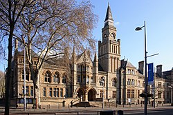
Ealing Town Hall was built in 1886, replacing an earlier hall on the same site. The architect was Charles Jones, who also designed several other buildings and features in the borough.

The borough was greatly enlarged in 1926 when it absorbed the urban districts of Greenford (including the parishes of Perivale and West Twyford) and Hanwell. [2] Accordingly, the size of the borough council was increased: by 1960 it consisted of a mayor, 16 aldermen and 48 councillors. [1] In 1952 there was a failed attempt to gain county borough status. [1]

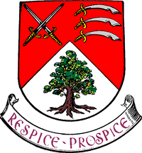
In 1965, under the London Government Act 1963, the municipal borough was abolished and its former area transferred to Greater London to be combined with the Municipal Borough of Acton and Municipal Borough of Southall to form the present-day London Borough of Ealing. [3] An oak in its coat of arms features, smaller, in the coat of arms of the London Borough of Ealing.

Coat of arms

Granted on 22 February 1902, the Municipal Borough's coat of arms (not to be confused with the modern borough's coat of arms) was: Per chevron gules and argent, in dexter chief two swords in saltire and in sinister chief three seaxes (Saxon swords) fessewise in pale all proper, with pommels and hilts or, and in base an oak tree eradicated (uprooted) also proper. The crossed swords are the symbol of Saint Paul and taken from the arms of the See of London, to which the manor historically belonged. The seaxes are from the arms of the county of Middlesex, and the tree was a symbol that Ealing is growing and flourishing. [4]

See also

Related Research Articles

<span class="mw-page-title-main">Middlesex</span> Historic county of England

Middlesex is a historic county in southeast England. Its area is almost entirely within the wider urbanised area of London and mostly within the ceremonial county of Greater London, with small sections in neighbouring ceremonial counties. Three rivers provide most of the county's boundaries; the Thames in the south, the Lea to the east and the Colne to the west. A line of hills forms the northern boundary with Hertfordshire.

<span class="mw-page-title-main">Metropolitan Borough of Hackney</span>

The Metropolitan Borough of Hackney was a metropolitan borough of the County of London from 1900 to 1965. Its area became part of the London Borough of Hackney.

<span class="mw-page-title-main">Metropolitan Borough of Stoke Newington</span>

The Metropolitan Borough of Stoke Newington was a metropolitan borough in the County of London between 1900 and 1965 when it became part of the London Borough of Hackney.

<span class="mw-page-title-main">County Borough of Croydon</span>

The County Borough of Croydon was a local government district in and around the town of Croydon in north east Surrey, England from 1889 to 1965. Since 1965 the district has been part of the London Borough of Croydon within Greater London.

<span class="mw-page-title-main">Municipal Borough of Finchley</span>

Finchley, which is now in north London, was a local government district in Middlesex, England, from 1878 to 1965. Finchley Local Board first met in 1878. It became Finchley Urban District Council in 1895 and the Municipal Borough of Finchley in 1933. In 1965 Middlesex was abolished and Finchley became part of the London Borough of Barnet.

<span class="mw-page-title-main">Municipal Borough of Bexley</span> Abolished 1965

Bexley was a local government district in north west Kent from 1879 to 1965 around the town of Old Bexley.

<span class="mw-page-title-main">Municipal Borough of Wembley</span> Former municipal borough in Middlesex, England

Wembley was an urban district and later a municipal borough in Middlesex, England from 1894 to 1965.

<span class="mw-page-title-main">Municipal Borough of Willesden</span> Former district in Middlesex, England

Willesden was a local government district in the county of Middlesex, England from 1874 to 1965. It formed part of the Metropolitan Police District and London postal district. Willesden was part of the built-up area of London and bordered the County of London to the east and south.

<span class="mw-page-title-main">Municipal Borough of Tottenham</span>

Tottenham was a local government district in north east Middlesex from 1850 to 1965. It was part of the London postal district and Metropolitan Police District.

<span class="mw-page-title-main">Municipal Borough of Acton</span>

Acton was a local government district in Middlesex, England from 1865 to 1965.

<span class="mw-page-title-main">Municipal Borough of Southall</span>

Southall was a local government district in the county of Middlesex, United Kingdom from 1891 to 1965. It consisted of the civil parish of Norwood.

<span class="mw-page-title-main">Municipal Borough of Enfield</span>

Enfield was a local government district in Middlesex, England from 1850 to 1965.

<span class="mw-page-title-main">Municipal Borough of Southgate</span>

Southgate was a local government district of Middlesex from 1881 to 1965. It was part of the London postal district and Metropolitan Police District.

<span class="mw-page-title-main">Municipal Borough of Edmonton</span>

Edmonton was a local government district in north-east Middlesex, England, from 1850 to 1965.

<span class="mw-page-title-main">Municipal Borough of Twickenham</span>

Twickenham was a local government district in Middlesex, England from 1868 to 1965.

<span class="mw-page-title-main">Municipal Borough of Wimbledon</span> Local government area of England

Wimbledon was a local government district in north-east Surrey from 1866 to 1965 covering the town of Wimbledon and its surrounding area. It was part of the London postal district and Metropolitan Police District.

<span class="mw-page-title-main">Staines Urban District</span> Former local government district in England

Staines was a local government district from 1894 to 1974 named after the English town of Staines.

<span class="mw-page-title-main">Municipal Borough of Brentford and Chiswick</span> Local government district in England

Brentford and Chiswick was a local government district of Middlesex, England from 1927 to 1965.

<span class="mw-page-title-main">Municipal Borough of Heston and Isleworth</span>

Heston and Isleworth was a local government district of Middlesex, England from 1894 to 1965.

<span class="mw-page-title-main">Acton Town Hall</span> Municipal building in London, England

Acton Town Hall is a municipal building in High Street, Acton, London, England. It is a Grade II listed building.

References

Notes
  1. 1 2 3 Baker, T.F.T.; Elrington, C.R. (1982). "'Ealing and Brentford: Local government', A History of the County of Middlesex: Volume 7: Acton, Chiswick, Ealing and Brentford, West Twyford, Willesden". British History Online. pp. 144–147. Retrieved 15 August 2011.
  2. Youngs 1979, p. ?
  3. "Ealing London Borough: Relationships and Changes". A Vision of Britain Through Time. University of Portsmouth. Retrieved 26 August 2016.
  4. "Coat of arms of Ealing". Heraldry of the World. Retrieved 16 April 2015.
Bibliography

51°30′47″N0°18′27″W / 51.5130°N 0.3076°W / 51.5130; -0.3076