Municipal Borough of Sutton and Cheam

Last updated

Sutton and Cheam
(Sutton from 1882 to 1928)
Area
  18911,836 acres (7.43 km2)
  19313,744 acres (15.15 km2)
  19614,338 acres (17.56 km2)
Population
  189110,334
  193146,500
  196179,008
Density
  18915.6/acre
  193112.4/acre
  196118.2/acre
History
  Origin Sutton parish
  Created1882
  Abolished1965
  Succeeded by London Borough of Sutton
Status local government district (1882—1894)
urban district (1894—1934)
municipal borough (1934—1965)
civil parish (1949—1965)
Government
   HQ Civic Offices, Throwley Road
   Motto Serve God and Be Cheerful
Arms-sut-chm.jpg
Coat of arms
Subdivisions
  Type Civil parish
  Units Sutton (1882—1949)
Cheam (1928—1949)

Sutton and Cheam was a local government district in northeast Surrey, England from 1882 to 1965.

Contents

History

Sutton Local Government District was formed on 20 December 1882, when the (civil) parish of Sutton adopted the Local Government Act 1858. Sutton Local Board was formed to govern the area. [1]

The Local Government Act 1894 reconstituted the district as Sutton Urban District and an urban district council replaced the local board.

In 1928 the Urban District grew to take in the westerly strip parish of Cheam (which was 4% larger) from Epsom Rural District and was thus renamed Sutton and Cheam Urban District. [2] Both occupy and are centred on spring line settlements next to the North Downs. The new body took in an extra 569 acres (2.3 km2) and 1840 people from 1933 when a county review order abolished Epsom Rural District, specifically drawing on parts of Banstead and Cuddington civil parishes. [3] At the same time about 212 versus 235 people's homes moved council by an imposed land exchange with Carshalton Urban District, seeing a net gain of 8 acres; three simultaneous changes moved no homes but saw a net gain of 16 acres. [3] The council successfully petitioned for a charter of incorporation so it became a municipal borough in 1934. [2] Charter Day was celebrated on 12 September 1934 with local festivities, including a quarter peal on the bells of All Saints, Benhilton. [4]

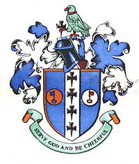
The borough was granted a coat of arms on incorporation. The shield had six emblems suggestive of the pan-medieval ecclesiastical landowners. The crosses came from the arms of the Archdiocese of Canterbury, the manor of Cheam having been granted to Christchurch, Canterbury in 1018. The keys of St Peter came from the arms of Chertsey Abbey who held Sutton at the time of the Domesday Book. The crest above the shield was a popinjay (parrot) from the arms of the Lumley family. The motto was that of John Hacket, rector of Cheam from 1624 - 1662 and was Bishop of Lichfield and Coventry in the last 10 years of his life. [5]

In 1965, under the London Government Act 1963, the borough was abolished and its land transferred to Greater London merging with Carshalton Urban District and the Municipal Borough of Beddington and Wallington to form the London Borough of Sutton.

Year188118911901191119211931193919511961
Population [6] [7] 10,33413,97717,22321,27021,06346,50073,59380,67379,008

Related Research Articles

<span class="mw-page-title-main">Morden</span> Human settlement in England

Morden is a district and town in South London, England, now within the London Borough of Merton, in the ceremonial county of Greater London. It adjoins Merton Park and Wimbledon to the north, Mitcham to the east, Sutton to the south and Worcester Park to the west, and is around 8 miles (13 km) south-southwest of Charing Cross. Prior to the creation of Greater London in 1965, for local government purposes, Morden was in the administrative and historic county of Surrey.

<span class="mw-page-title-main">London Borough of Sutton</span> Borough in London, England

The London Borough of Sutton is an Outer London borough in London, England. It covers an area of 43 km2 (17 sq mi) and is the 80th largest local authority in England by population. It borders the London Borough of Croydon to the east, the London Borough of Merton to the north and the Royal Borough of Kingston upon Thames to the north-west; it also borders the Surrey boroughs of Epsom and Ewell to the west and Reigate and Banstead to the south. The local authority is Sutton London Borough Council. Its principal town is Sutton.

<span class="mw-page-title-main">Reigate and Banstead</span> Borough and non-metropolitan district in England

Reigate and Banstead is a local government district with borough status in Surrey, England. Its council is based in Reigate and the borough also includes the towns of Banstead, Horley and Redhill. Parts of the borough are within the Surrey Hills, a designated Area of Outstanding Natural Beauty. Northern parts of the borough, including Banstead, lie inside the M25 motorway which encircles London.

<span class="mw-page-title-main">Epsom and Ewell</span> Borough and non-metropolitan district in England

Epsom and Ewell is a local government district with borough status in Surrey, England, covering the towns of Epsom and Ewell. The borough lies just outside the administrative boundary of Greater London, but it is entirely within the M25 motorway which encircles London. Many of the borough's urban areas form part of the wider Greater London Built-up Area.

<span class="mw-page-title-main">Banstead</span> Town in Surrey, England

Banstead is a town in the borough of Reigate and Banstead in Surrey, England. It is 3 miles (5 km) south of Sutton, 5 miles (8 km) south-west of Croydon, 8 miles (13 km) south-east of Kingston-upon-Thames, and 13 miles (21 km) south of Central London.

<span class="mw-page-title-main">Epsom (UK Parliament constituency)</span> Parliamentary constituency in the United Kingdom, 1885–1974

Epsom was a borough constituency represented in the House of Commons of the Parliament of the United Kingdom. It elected one Member of Parliament (MP) by the first past the post system of election. From its creation in 1885 until its abolition in 1974, it was won by eight Conservatives. The winner took less than 50% of the votes in its contested elections once, in 1945, receiving 49.9% of the vote in a three-party contest. Six elections, the last being a by-election in 1912, were uncontested.

<span class="mw-page-title-main">Ewell</span> Town in Surrey, England

Ewell is a town in the borough of Epsom and Ewell in Surrey, England. It is approximately 12 miles (19 km) south of central London and 2 miles (3.2 km) northeast of Epsom. In the 2011 Census, the town had a population of 34,872. The majority of which (73%) is in the ABC1 social class, except the Ruxley Ward that is C2DE.

<span class="mw-page-title-main">County Borough of Croydon</span> Former local government district in Surrey, England

The County Borough of Croydon was a local government district in and around the town of Croydon in north east Surrey, England from 1889 to 1965. Since 1965 the district has been part of the London Borough of Croydon within Greater London.

<span class="mw-page-title-main">Coulsdon and Purley Urban District</span> Local government district in Surrey, England

Coulsdon and Purley Urban District was a local government district in northeast Surrey from 1915 to 1965. The local authority was Coulsdon and Purley Urban District Council. The former area of the district is now mostly part of the London Borough of Croydon in Greater London, with parts in the Tandridge District and the Borough of Reigate and Banstead in Surrey.

<span class="mw-page-title-main">Municipal Borough of Twickenham</span>

Twickenham was a local government district in Middlesex, England from 1868 to 1965.

<span class="mw-page-title-main">Carshalton Urban District</span> Local government district in England

Carshalton was a local government district in north east Surrey from 1883 to 1965 around the town of Carshalton.

<span class="mw-page-title-main">Municipal Borough of Surbiton</span> Former local government district in Surrey, England

Surbiton was a local government district in northeast Surrey, United Kingdom, from 1855 to 1965.

<span class="mw-page-title-main">London Government Act 1963</span> United Kingdom legislation

The London Government Act 1963 is an act of the Parliament of the United Kingdom, which created Greater London and a new local government structure within it. The Act significantly reduced the number of local government districts in the area, resulting in local authorities responsible for larger areas and populations. The upper tier of local government was reformed to cover the whole of the Greater London area and with a more strategic role; and the split of functions between upper and lower tiers was recast. The Act classified the boroughs into inner and outer London groups. The City of London and its corporation were essentially unreformed by the legislation. Subsequent amendments to the Act have significantly amended the upper tier arrangements, with the Greater London Council abolished in 1986, and the Greater London Authority introduced in 2000. As of 2024, the London boroughs are more or less identical to those created in 1965, although with some enhanced powers over services such as waste management and education.

<span class="mw-page-title-main">Merton and Morden Urban District</span>

Merton Urban District (1907–1913) and Merton and Morden Urban District (1913–1965) was an urban district in Surrey, England. It was formed in 1907 from the parish of Merton and was expanded in 1913 to take in Morden. The district was abolished in 1965 and its former area now forms part of the London Borough of Merton in Greater London.

Epsom was a rural district of Surrey from 1894 to 1933.

<span class="mw-page-title-main">Municipal Borough of Beddington and Wallington</span>

Beddington and Wallington was, from 1915 to 1965, a local government district in north east Surrey, England. It formed part of the London suburbs, lying within the Metropolitan Police District and the London Passenger Transport Area. In 1965 it was abolished on the creation of Greater London.

<span class="mw-page-title-main">Municipal Borough of Wanstead and Woodford</span>

Wanstead and Woodford was a local government district from 1934 to 1965 in southwest Essex, England. A merger of two former urban districts, it was suburban to London and part of the Metropolitan Police District.

<span class="mw-page-title-main">Municipal Borough of Richmond (Surrey)</span>

The Municipal Borough of Richmond or Richmond Municipal Borough was a municipal borough in Surrey, England from 1890 to 1965.

<span class="mw-page-title-main">Wallington Hundred</span>

Wallington was an ancient hundred in the northeast of the historic county of Surrey, England. The majority of its area has been absorbed by the growth of London; with its name currently referring to the district of Wallington. Its former area now corresponds to the London Borough of Sutton, the majority of the London Borough of Croydon and parts of the London Borough of Merton as well as parts of the Districts of Epsom and Ewell, Reigate and Banstead and Tandridge in Surrey.

The Royal Commission on Local Government in Greater London, also known as the Herbert Commission, was established in 1957 and published its report in 1960. The report made recommendations for the overhaul of the administration of the capital. They were modified and implemented by the London Government Act 1963.

References

  1. Kelly's Directory of Kent, Surrey & Sussex, 1891, p.1503 (Historical Directories), accessed 5 February 2008
  2. 1 2 Frederic A Youngs Jr., A Guide to the Local Administrative Units of England, Vol I: Southern England, London, 1979
  3. 1 2 "Statistical resource, the University of Portsmouth and others". Vision of Britain. 1 April 1933.
  4. "Sutton Charter Day Ringing". The Ringing World . 21 September 1934. p. 602.
  5. C W Scott-Giles, Civic Heraldry of England and Wales, 2nd edition, London, 1953
  6. "Sutton AP/CP through time | Population Statistics | Total Population". Visionofbritain.org.uk. Retrieved 13 May 2020.
  7. "Sutton and Cheam MB/UD through time | Population Statistics | Total Population". Visionofbritain.org.uk. Retrieved 13 May 2020.

51°22′N0°12′W / 51.36°N 0.20°W / 51.36; -0.20