Metropolitan Borough of Hampstead

Last updated

Hampstead
Former Hampstead town hall, Haverstock Hill - geograph.org.uk - 415063.jpg
Hampstead Town Hall
Metropolitan Borough of Hampstead.svg
Hampstead within the former County of London
History
  Created1900
  Abolished1965
  Succeeded by London Borough of Camden
Status Metropolitan borough
GovernmentHampstead Borough Council
   HQ Haverstock Hill
   Motto Non Sibi Sed Toti (Not for self but for all)
Coat of Arms of the Metropolitan Borough of Hampstead.svg
Coat of arms of the borough council [1]
Metropolitan Borough of Hampstead 
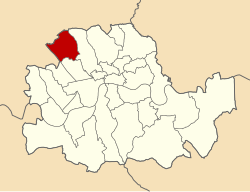
Map of borough boundary

Hampstead was a civil parish and metropolitan borough in London, England. It was an ancient parish in the county of Middlesex, governed by an administrative vestry. The parish was included in the area of responsibility of the Metropolitan Board of Works in 1855 and became part of the County of London in 1889. The parish of Hampstead became a metropolitan borough in 1900, following the London Government Act 1899, with the parish vestry replaced by a borough council. In 1965 the borough was abolished and its former area became part of the London Borough of Camden in Greater London.

Contents

Geography

It included Primrose Hill, Hampstead, Belsize Park, West Hampstead, South Hampstead, much of Hampstead Heath and part of Kilburn and Cricklewood. Some street signs still bear the 'Borough of Hampstead' name.

Ecclesiastical parish

Street sign still bearing the 'Borough of Hampstead' name in 2007. Shoot-Up Hill road name plate, retaining "Borough of Hampstead" text (cropped).jpg
Street sign still bearing the 'Borough of Hampstead' name in 2007.

The ancient parish, was originally dedicated to St Mary, but in 1747 it was rededicated to St John. It was in the Diocese of London. From 1852, as the population of Hampstead increased, a number of new parishes were formed: [2]

In addition, as the population of neighbouring areas increased, parts of Hampstead parish were included in new parishes:

Coat of arms

The borough's coat of arms on Hampstead War Memorial Hampstead War Memorial front detail.jpg
The borough's coat of arms on Hampstead War Memorial

The arms were granted in 1931, and are based on a device used by the Hampstead Vestry without authority, and adopted by the Council on its formation in 1900.

The mitre stands for the Westminster Abbey, to which the Manor of Hampstead was granted by Ethelred the Unready in 986, and remained in its possession until 1539. The fleurs-de-lys and stag's head are from the arms of the Hickes family, one of whom, Viscount Camden, purchased the Manor. On his death in 1629 it passed to the Noel family from whose arms are taken the fretty chief. The Manor was sold to Sir William Langthorne in 1707, who is represented by the white cross and red fleurs-de-lys from his arms.

The holly is from the seal of the old Hampstead Vestry, which grows profusely in the area.

Charges from these arms were used, together with charges from the coats of arms of Holborn and of St. Pancras, when the new coat of arms of the London Borough of Camden was designed in 1965.

The former coat of arms can still be seen on Hampstead War Memorial.

Population and area

Template:Attached KML/Metropolitan Borough of Hampstead
KML is not from Wikidata

The metropolitan borough was conterminous with the Vestry authority, when it was formed in 1900. Statistics compiled by the London County Council, in 1901 to show the population growth in London, over the preceding century.

Hampstead had an area of 2,265 acres (9.2 km2) in 1901. The populations recorded in National Censuses were:

Hampstead Vestry 1801-1899

Year [3] 1801181118211831184118511861187118811891
Population4,4345,4837,2638,58810,09311,98619,10632,28145,45268,416

Metropolitan Borough 1900-1961

Year [4] 1901191119211931194119511961
Population81,94285,49586,15388,947 [5] 95,13198,844

Politics

A map showing the wards of Hampstead Metropolitan Borough as they appeared in 1916. Hampstead Met. B Ward Map 1916.svg
A map showing the wards of Hampstead Metropolitan Borough as they appeared in 1916.

Under the Metropolis Management Act 1855 any parish that exceeded 2,000 ratepayers was to be divided into wards; however the parish of St John Hampstead did not exceed this number so was not divided into wards. By 1873 its population had increased enough for the incorporated vestry to be divided into four wards (electing vestrymen): No. 1 (18), No. 2 (15), No. 3 (15) and No. 4 (12). [6]

In 1894 as its population had increased further so the incorporated vestry was re-divided into five wards (electing vestrymen): Town (18), Belsize (12), Adelaide (9), Kilburn (21) and West End (12). [7] [8]

The metropolitan borough was divided into seven wards for elections: Adelaide, Belsize, Central, Kilburn, Priory, Town and West End. [9] [10]

Parliament constituency

For elections to Parliament, the borough was represented by one constituency:

Related Research Articles

<span class="mw-page-title-main">Metropolitan Borough of Camberwell</span> Former Metropolitan Borough in England

Camberwell was a civil parish and metropolitan borough in south London, England. Camberwell was an ancient parish in the county of Surrey, governed by an administrative vestry from 1674. The parish was included in the area of responsibility of the Metropolitan Board of Works in 1855 and became part of the County of London in 1889. The parish of Camberwell became a metropolitan borough in 1900, following the London Government Act 1899, with the parish vestry replaced by a borough council. In 1965 the borough was abolished and its former area became part of the London Borough of Southwark in Greater London.

<span class="mw-page-title-main">Metropolitan Borough of Lambeth</span> Metropolitan borough of England

Lambeth was a civil parish and metropolitan borough in south London, England. It was an ancient parish in the county of Surrey. The parish was included in the area of responsibility of the Metropolitan Board of Works in 1855 and became part of the County of London in 1889. The parish of Lambeth became a metropolitan borough in 1900, following the London Government Act 1899, with the parish vestry replaced by a borough council.

<span class="mw-page-title-main">Metropolitan Borough of Paddington</span> Former borough of London

Paddington was a civil parish and metropolitan borough in London, England. It was an ancient parish in the county of Middlesex, governed by an administrative vestry. The parish was included in the area of responsibility of the Metropolitan Board of Works in 1855 and became part of the County of London in 1889. The parish of Paddington became a metropolitan borough in 1900, following the London Government Act 1899, with the parish vestry replaced by a borough council. In 1965 the borough was abolished and its former area became part of the City of Westminster in Greater London.

<span class="mw-page-title-main">Metropolitan Borough of St Marylebone</span> Metropolitan borough of England

The Metropolitan Borough of St Marylebone was a metropolitan borough of the County of London from 1900 to 1965. It was based directly on the previously existing civil parish of St Marylebone, Middlesex, which was incorporated into the Metropolitan Board of Works area in 1855, retaining a parish vestry, and then became part of the County of London in 1889.

<span class="mw-page-title-main">Metropolitan Borough of St Pancras</span> Metropolitan borough of England

St Pancras was a civil parish and metropolitan borough in London, England. It was an ancient parish in the county of Middlesex, governed by an administrative vestry. The parish was included in the area of responsibility of the Metropolitan Board of Works in 1855 and became part of the County of London in 1889. The parish of St Pancras became a metropolitan borough in 1900, following the London Government Act 1899, with the parish vestry replaced by a borough council. In 1965 the borough was abolished and its former area became part of the London Borough of Camden in Greater London.

<span class="mw-page-title-main">Metropolitan Borough of Islington</span> Former local authority of London, England

Islington was a civil parish and metropolitan borough in London, England. It was an ancient parish within the county of Middlesex, and formed part of The Metropolis from 1855. The parish was transferred to the County of London in 1889 and became a metropolitan borough in 1900. It was amalgamated with the Metropolitan Borough of Finsbury to form the London Borough of Islington in Greater London in 1965.

<span class="mw-page-title-main">Metropolitan Borough of Chelsea</span> Former borough of London

The Metropolitan Borough of Chelsea was a metropolitan borough of the County of London between 1900 and 1965. It was created by the London Government Act 1899 from most of the ancient parish of Chelsea. Following the London Government Act 1963, it was amalgamated with the Royal Borough of Kensington in 1965 to form the Royal Borough of Kensington and Chelsea.

<span class="mw-page-title-main">Metropolitan Borough of Kensington</span> Former borough of London

The Metropolitan Borough of Kensington was a Metropolitan borough in the County of London from 1900 to 1965, which since 1901 was known as the Royal Borough of Kensington, following the death of Queen Victoria, in accordance with her wishes.

<span class="mw-page-title-main">Metropolitan Borough of Fulham</span>

The Metropolitan Borough of Fulham was a metropolitan borough in the County of London between 1900 and 1965, when it was merged with the Metropolitan Borough of Hammersmith to form the London Borough of Hammersmith and Fulham. It was a riverside borough, and comprised the many centuries-long definition of Fulham so included parts often considered of independent character today Walham Green, Parsons Green, Hurlingham, Sands End and that part of Chelsea Harbour west of Counter's Creek. The SW6 postal district approximately follows this as does the direct, though less empowered, predecessor Fulham civil parish.

<span class="mw-page-title-main">Metropolitan Borough of Hammersmith</span>

Hammersmith was a civil parish and metropolitan borough in London, England. It was formed as a civil parish in 1834 from the chapelry of Hammersmith that had existed in the ancient parish of Fulham, Middlesex since 1631. The parish was grouped with Fulham as the Fulham District from 1855 until 1886, when separate parish administration was restored. In 1889 it became part of the County of London and in 1900 it became a metropolitan borough. It included Hammersmith, Wormwood Scrubs, Old Oak Common and Shepherd's Bush. In 1965 it was abolished and became the northern part of the London Borough of Hammersmith, since 1979 renamed the London Borough of Hammersmith and Fulham.

<span class="mw-page-title-main">Metropolitan Borough of Hackney</span>

The Metropolitan Borough of Hackney was a metropolitan borough of the County of London from 1900 to 1965. Its area became part of the London Borough of Hackney.

<span class="mw-page-title-main">Metropolitan Borough of Poplar</span>

Poplar was a local government district in the metropolitan area of London, England. It was formed as a district of the Metropolis in 1855 and became a metropolitan borough in the County of London in 1900. It comprised Poplar, Millwall, Bromley-by-Bow and Bow as well as Old Ford, Fish Island and Cubitt Town.

<span class="mw-page-title-main">Metropolitan Borough of Stoke Newington</span>

The Metropolitan Borough of Stoke Newington was a metropolitan borough in the County of London between 1900 and 1965 when it became part of the London Borough of Hackney.

<span class="mw-page-title-main">Metropolitan Borough of Shoreditch</span>

The Metropolitan Borough of Shoreditch was a metropolitan borough of the County of London between 1899 and 1965, when it was merged with the Metropolitan Borough of Stoke Newington and the Metropolitan Borough of Hackney to form the London Borough of Hackney.

<span class="mw-page-title-main">Swiss Cottage</span> Area of Hampstead in London, England

Swiss Cottage is an area of Hampstead in the London Borough of Camden, England. It is centred on the junction of Avenue Road and Finchley Road and includes Swiss Cottage tube station. Swiss Cottage lies 3.25 miles (5.23 km) north-northwest of Charing Cross. The area was named after a public house in the centre of it, known as "Ye Olde Swiss Cottage".

<span class="mw-page-title-main">Hampstead and Highgate (UK Parliament constituency)</span> Parliamentary constituency in the United Kingdom, 1983–2010

Hampstead & Highgate was a parliamentary constituency covering the northern half of the London Borough of Camden which includes the village of Hampstead and part of that of Highgate.

<span class="mw-page-title-main">Hampstead (UK Parliament constituency)</span> Former UK Parliament constituency, 1885–1983

Hampstead was a borough constituency, centered on the Hampstead area of North London. It returned one Member of Parliament (MP) to the House of Commons of the Parliament of the United Kingdom, who was elected using the first-past-the-post voting system.

Plumstead (1855–1894) and then Lee (1894–1900) was a local government district within the metropolitan area of London from 1855 to 1900. It was formed as the Plumstead district by the Metropolis Management Act 1855 and was governed by the Plumstead District Board of Works, which consisted of elected vestrymen.

<span class="mw-page-title-main">London Borough of Camden</span> London borough in United Kingdom

The London Borough of Camden is a London borough in Inner London, England. Camden Town Hall, on Euston Road, lies 1.4 mi (2.3 km) north of Charing Cross. The borough was established on 1 April 1965 and includes the former Central London borough of Holborn and St Pancras and Hampstead.

Hackney was a local government district within the metropolitan area of London, England from 1855 to 1894. It was formed by the Metropolis Management Act 1855 and was governed by the Hackney District Board of Works, which consisted of elected vestrymen. It was in the part of the county of Middlesex that was within the area of the Metropolitan Board of Works. In 1889 it became part of the County of London and the district board functioned as a local authority under the London County Council.

References

  1. "Hampstead - Coat of arms (crest) of Hampstead". Heraldry of the World. Retrieved 12 August 2022.
  2. "Hampstead: Churches', A History of the County of Middlesex: Volume 9: Hampstead, Paddington". 1989. pp. 145–152. Retrieved 13 March 2014.
  3. Statistical Abstract for London, 1901 (Vol. IV).
  4. Metropolitan Borough of Hampstead: Census Tables at Vision of Britain accessed on 14 Dec 2006
  5. The census was suspended for World War II
  6. The London Gazette Issue: 23955. 4 March 1873. pp. 1370–1371. Retrieved 9 April 2015.
  7. The London Gazette Issue: 26526. 26 June 1894. p. 3673. Retrieved 9 April 2015.
  8. The London Gazette Issue: 26548. 4 September 1894. pp. 5154–5155. Retrieved 9 April 2015.
  9. Post Office London County Suburbs Directory, 1919. 1919. Retrieved 18 February 2015.
  10. Ordnance Survey 'County Series 3rd Edition' Map of London (1912-14) at 1:2500 scale. Accessed at https://www.old-maps.co.uk/

Further reading

51°33′04″N0°10′42″W / 51.5510°N 0.1783°W / 51.5510; -0.1783