St Andrew Holborn (parish)

Last updated

St Andrew Holborn
History
  OriginAncient parish
  Abolished1907
  Succeeded byReduced 1723: see St George the Martyr
Reduced 1767: see St Andrew Holborn Above the Bars with St George the Martyr
above both de facto largely replaced in 1855 by Holborn District.

Remaining Below the Bars element gradually replaced in importance by Farringdon Without Ward of the City, de facto. De jure replaced as the whole of the City of London was constituted a civil parish 1907 until abolished in 1965. [1]
Status Civil parish

St Andrew Holborn was an ancient English parish that until 1767 was partly in the City of London and mainly in the county of Middlesex. Its City, thus southern, part retained its former name or was sometimes officially referred to as St Andrew Holborn Below the Bars. [2]

Contents

History

Ecclesiastical origins

Thavie's original property, which was left for his endowment of the church, Thavie's Inn became a lawyers inn and may have been the original home of Lincoln's Inn before it relocated to its present site. Lincoln's sold Thavies Inn for redevelopment in 1785. Earlier that century the small east stained-glass window was put up, representing the arms of John Thavie, Esq., who in the year 1348 "left a considerable estate towards the support of this fabric for ever" as its caption reads.

Under an Act of Parliament passed in the reign of Queen Anne and [related proceedings] the parish of St. George the Martyr, Queen Square, which before had formed part of St. Andrew's, Holborn, was erected into a distinct parish for spiritual purposes, although still united with St. Andrew's as regards the poor, and other secular matters.

Thornbury, Old London, New London 1878 [3]

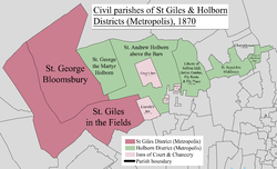
Four other new smaller parishes took over the largest green area depicted and most of Gray's Inn:

Newcourt informs us that a public grammar school was among the adjuncts of the church. It was one of those erected by Act of Parliament in the reign of Henry VI. and, according to Maitland, stood on the right side of the church, and was taken down in 1737. [3]

Civil parishes (as regards secular matters)

St Giles & Holborn Civil Parish Map 1870.png

In 1723 the Middlesex bulk of the ecclesiastical parish was first split: its north-west corner became St George the Martyr, Queen Square (not to be confused with St George, Bloomsbury to the immediate west) and the rest remained St Andrew, Holborn. The two however recombined for civic, secular purposes in 1767 to create St Andrew Holborn Above the Bars with St George the Martyr; the latter at approximately the same time shed its part in the City of London to become its own parish as to lay purposes: St Andrew Holborn Below the Bars and over time under the auspices of the Farringdon Without City Ward.

Both parishes bore quasi-civil parish (CP) areas separate from their parochial church councils. By comparison and not to be confused St Giles in the Fields and St George Bloomsbury Ancient Parish-turned Civil Parish existed 1774-1930. [5] St Andrew Holborn Below the Bars existed abolished as a civil parish 1767-1907. [6]

Geography

The ancient parish included most of the Holborn area to the west, bordering onto St Giles in the Fields. As such it included both Lincoln's Inn and Gray's Inn which rented pews in the church of St Andrew, Holborn, first mentioned according to Thornbury's Old and New London (1878) "given by one Gladerinus to the Dean and Chapter of St. Paul's"; [3] rebuilt to Wren's designs in 1686. City of London civil parishes Map 1870.png

Population

St Andrew Holborn, City of London
Year1871188118911901
Population3,8182,8832,5701,365

Related Research Articles

<span class="mw-page-title-main">Holborn</span> Human settlement in England

Holborn is a district in central London, which covers the south-eastern part of the London Borough of Camden and a part of the Ward of Farringdon Without in the City of London.

<span class="mw-page-title-main">Metropolitan Borough of Holborn</span> Metropolitan borough in London

The Metropolitan Borough of Holborn was a metropolitan borough in the County of London between 1900 and 1965. The borough included most of Holborn as well as Bloomsbury and St Giles.

<span class="mw-page-title-main">Saffron Hill</span> Street in the London Borough of Camden

Saffron Hill is a street and former ward in Holborn, in the south eastern corner of the London Borough of Camden, between Farringdon Road and Hatton Garden. The name of the street derives from the fact that it was at one time part of an estate on which saffron grew. The ecclesiastical parish was St Peter, Saffron Hill, a daughter parish of Holborn, which is now combined with St Alban, Holborn.

<span class="mw-page-title-main">Staple Inn</span> Tudor building in London, England

Staple Inn is a part-Tudor building on the south side of High Holborn street in the City of London, London, England. Located near Chancery Lane tube station, it is used as the London venue for meetings of the Institute and Faculty of Actuaries, and is the last surviving Inn of Chancery. It was designated a Grade I listed building in 1974.

The Holborn Division was one of four divisions of the Hundred of Ossulstone, in the county of Middlesex, England. The other divisions were named Finsbury, Kensington and Tower.

<span class="mw-page-title-main">Bills of mortality</span>

Bills of mortality were the weekly mortality statistics in London, designed to monitor burials from 1592 to 1595 and then continuously from 1603. The responsibility to produce the statistics was chartered in 1611 to the Worshipful Company of Parish Clerks. The bills covered an area that started to expand as London grew from the City of London, before reaching its maximum extent in 1636. New parishes were then only added where ancient parishes within the area were divided. Factors such as the use of suburban cemeteries outside the area, the exemption of extra-parochial places within the area, the wider growth of the metropolis, and that they recorded burials rather than deaths, rendered their data incomplete. Production of the bills went into decline from 1819 as parishes ceased to provide returns, with the last surviving weekly bill dating from 1858. They were superseded by the weekly returns of the Registrar General from 1840, taking in further parishes until 1847. This area became the district of the Metropolitan Board of Works in 1855, the County of London in 1889 and Inner London in 1965.

The parliamentary borough of Finsbury was a constituency of the House of Commons of the UK Parliament from 1832 to 1885, and from 1918 to 1950. The constituency was first created in 1832 as one of seven two-seat "metropolis" parliamentary boroughs other than the two which already existed: Westminster and the City of London; the latter until 1885 retained an exceptional four seats. Finsbury was directly north of the City of London and was smaller than the Finsbury division of the Ossulstone hundred but took in land of Holborn division to its southwest in pre-introduction changes by Boundary Commissioners. It included Finsbury, Holborn, Moorfields, Clerkenwell, Islington, Stoke Newington and historic St Pancras. The 1918 constituency corresponded to the smaller Metropolitan Borough of Finsbury ; it was a seat, thus electing a single member, fulfilling a longstanding aim of Chartism which underscored the 1832 reforms.

<span class="mw-page-title-main">Ely Place</span>

Ely Place is a gated road of multi-storey terraces at the southern tip of the London Borough of Camden in London, England. It hosts a 1773-rebuilt public house, Ye Olde Mitre, of Tudor origin and is adjacent to Hatton Garden.

<span class="mw-page-title-main">Holborn (UK Parliament constituency)</span> Parliamentary constituency in the United Kingdom, 1885–1950

Holborn was a parliamentary constituency centred on the Holborn district of Central London. It returned one Member of Parliament (MP) to the House of Commons of the Parliament of the United Kingdom.

<span class="mw-page-title-main">Farringdon Without</span> Ward of the City of London

Farringdon Without is the most westerly Ward of the City of London, England. Its suffix Without reflects its origin as lying beyond the City's former defensive walls. It was first established in 1394 to administer the suburbs west of Ludgate and Newgate, including West Smithfield and Temple. This was achieved by splitting the very large, pre-existing Farringdon Ward into two parts, Farringdon Within and Farringdon Without. The large and prosperous extramural suburb of Farringdon Without has been described as having been London's first West End.

<span class="mw-page-title-main">St Andrew Holborn (church)</span> Church in London, England

The Church of St Andrew, Holborn, is a Church of England church on the northwestern edge of the City of London, on Holborn within the Ward of Farringdon Without.

<span class="mw-page-title-main">Furnival's Inn</span>

Furnival's Inn was an Inn of Chancery which formerly stood on the site of the present Holborn Bars building in Holborn, London, England.

<span class="mw-page-title-main">Chancery Lane</span> London street in the ward of Farringdon Without

Chancery Lane is a one-way street situated in the ward of Farringdon Without in the City of London. It has formed the western boundary of the City since 1994, having previously been divided between the City of Westminster and the London Borough of Camden. The route originated as a 'new lane' created by the Knights Templar from their original 'old Temple' on the site of the present Southampton Buildings on Holborn, in order to access to their newly acquired property to the south of Fleet Street sometime before 1161.

<span class="mw-page-title-main">Holborn District (Metropolis)</span>

Holborn was a local government district in the metropolitan area of London to the north west of the City of London from 1855 to 1900.

<span class="mw-page-title-main">St Giles District (Metropolis)</span>

St Giles District was a local government district in the metropolitan area of London, England from 1855 to 1900. The district was created by the Metropolis Management Act 1855, and comprised the civil parish of St Giles in the Fields and St George Bloomsbury, Middlesex: the two parishes had been combined for civil purposes in 1774. The district was abolished in 1900 and its former area became part of the Metropolitan Borough of Holborn. The civil parish was abolished in 1930. It is now part of the London Borough of Camden.

Thavie's Inn was a former Inn of Chancery, associated with Lincoln's Inn, established at Holborn, near the site of the present side street and office block still known as Thavies Inn Buildings. Thavie's Inn is one of the earliest Inns of Chancery on record, both by date of establishment and dissolution. It remains a well-known City of London landmark, where Lloyd's Bank is situated, on the opposite side of Holborn Circus from Ely Place.

<span class="mw-page-title-main">St Andrew Holborn Above the Bars with St George the Martyr</span>

St Andrew Holborn Above the Bars with St George the Martyr was a civil parish in the metropolitan area of London, that existed from 1767 to 1930. The four Inns of Court are all within the parish.

<span class="mw-page-title-main">Saffron Hill, Hatton Garden, Ely Rents and Ely Place</span>

Saffron Hill, Hatton Garden, Ely Rents and Ely Place was a liberty and from 1866 to 1930 a civil parish in the metropolitan area of London, England. It was part of the ancient parish of St Andrew Holborn.

<span class="mw-page-title-main">Coat of arms of the London Borough of Camden</span>

The coat of arms of the London Borough of Camden were granted on 10 September 1965. The borough was formed by the merger of three former boroughs, namely the Metropolitan Borough of Hampstead, the Metropolitan Borough of Holborn and the Metropolitan Borough of St. Pancras, from whose arms elements were utilised in the arms of the new borough.

References

  1. Great Britain Historical GIS / University of Portsmouth, City of London (civil parish). Retrieved 31 January 2010.
  2. Youngs, Frederic (1979). Guide to the Local Administrative Units of England. Vol. I: Southern England. London: Royal Historical Society. ISBN   0-901050-67-9.
  3. 1 2 3 Walter Thornbury, 'Farringdon Street, Holborn Viaduct and St. Andrew's church', in Old and New London: Volume 2 (London, 1878), pp. 496-513. British History Online http://www.british-history.ac.uk/old-new-london/vol2/pp496-513 [accessed 20 August 2017].
  4. Charles Booth (social reformer)'s poverty map: http://booth.lse.ac.uk/map/17/-0.1144/51.5204/100/0
  5. F. Youngs, Local Administrative Units: Southern England (London: Royal Historical Society, 1979), p. 340.
  6. F. Youngs, Local Administrative Units: Southern England (London: Royal Historical Society, 1979), p. 298.