Bloomsbury's built heritage is currently protected by the designation of a conservation area and a locally based conservation committee. Despite this, there is increasing concern about a trend towards larger and less sensitive development, and the associated demolition of Victorian and Georgian buildings.[5]
Bloomsbury (including the closely linked St Giles area) has a long association with neighbouring Holborn, but is nearly always considered as distinct from Holborn.
Origins and etymology
The area appears to have been a part of the parish of Holborn when St Giles hospital was established in the early 1100s.[6]
The earliest record of the name, Bloomsbury, is as Blemondisberi in 1281. It is named after a member of the Blemund family who held the manor. There are older records relating to the family in London in 1201 and 1230. Their name, Blemund, derives from Blemont, a place in Vienne, in western France.[7] At the end of the 14th century, Edward III acquired Blemond's manor, and passed it on to the Carthusian monks of the London Charterhouse. The area remained rural at this time.
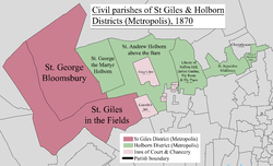
The area was part of the Ancient Parish of St Giles, served by the church of St Giles in the Fields. Some sources indicate that the parish was in place before 1222[8] while others suggest 1547.[9] From 1597 onwards, English parishes were obliged to take on a civil as well as ecclesiastical role, starting with the relief of the poor.
In 1731 a small new independent parish of Bloomsbury was created, based on a small area round Bloomsbury Square. In 1774 these parishes recombined, for civil purposes, to form the parish of St Giles in the Fields and St George Bloomsbury – which had the same boundaries as the initial parish of St Giles.[9]
The area of the combined civil parish was used for the St Giles District (Metropolis), established under the Metropolis Management Act 1855.[10] This body managed certain infrastructure functions, while the civil parish continued with its responsibilities until the abolishment of the Poor Law in 1930; however it was not formally abolished until the creation of Greater London in 1965.
The combined parishes of St Giles in the Fields and St George Bloomsbury (west) joined with most of Holborn District to form the Met. Borough of Holborn, in 1900
In 1900 the area of the St Giles District (Metropolis) merged with Holborn District (Metropolis) (excluding those parts of Finsbury Division which had been temporarily attached to Holborn) to form a new Metropolitan Borough of Holborn. The traditional boundaries of St Giles and Bloomsbury were used for wards in the new borough, though these were subject to minor rationalisations to reflect the modern street pattern rather than the historic basis of the older streets and pre-urban field boundaries. The combined civil parish continued to operate, in parallel, for a considerable time after.
The formal historic boundaries of the combined parish of St Giles in the Fields and St George Bloomsbury (as adjusted in some places to reflect the modern street pattern) include Tottenham Court Road to the west, Torrington Place (formerly known, in part, as Francis Street) to the north, the borough boundary to the south and Marchmont Street and Southampton Row to the east.
Wards of the Metropolitan Borough of Holborn, 1952. Bloomsbury and St Giles (including most of Lincoln's Inn) were sub-divided but retained their identity
The eastern boundary is sometimes taken to be in the region of Southampton Row[11] or further east on Grays Inn Road.[2] The southern extent is taken to approximates to High Holborn or the thoroughfare formed by New Oxford Street, Bloomsbury Way and Theobalds Road.
On the west side, the traditional and various informal definitions of the area are all based on the ancient Tottenham Court Road. The differences between the formal and more recent understandings of the area (to the north and south), seem to derive from Bloomsbury having been commonly misconceived as being coterminous with the Bedford Estate.[12]
The area was laid out mainly in the 18th century, largely by Wriothesley Russell, 3rd Duke of Bedford, who built Bloomsbury Market, which opened in 1730. His younger brother, John Russell, 4th Duke of Bedford, would have built a circus here but he died in 1771, leaving his wife to continue development of the area. She commissioned the construction of Bedford Square and of Gower Street.[14] The major development of the squares that we see today started in about 1800 when Francis Russell, 5th Duke of Bedford, demolished Bedford House[14] and developed the land to the north with Russell Square as its centrepiece. Much is still owned today by the Bedford Estate in trust for the Russell family.
John Russell, 6th Duke of Bedford, extended development on the north and east side of the estate, this area would then be frequented by writers, painters and musicians as well as lawyers due to the nearby Inns of Court. The area was enclosed by gates until these were abolished under a 1893 Act of Parliament. In the 19th century, the Bloomsbury area became less fashionable, now dominated by the University of London and the British Museum as well as numerous new hospitals. Modern development has destroyed several Georgian-era buildings, but some remain.[14]
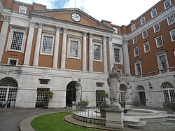
Pied Bull Yard, in the Bloomsbury Conservation Area
All of the geographic area of Bloomsbury is covered by the Bloomsbury Conservation Area, an historic designation designed to limit new development, and ensure that changes to the built environment preserve and enhance its special character. This conservation area is one of the oldest and most significant in the UK, having been designated in 1968, less than a year after conservation areas were promulgated in the Civic Amenities Act 1967.[16]
The Bloomsbury Conservation Area is almost unique in the UK in that it also has a conservation area advisory committee, an expert committee of architects, planners, lawyers, and other community members that also live and work in Bloomsbury.[17] This group was founded in 1968 by the local authority and continues to serve Bloomsbury and the surrounding area. It is generally thought that the Bloomsbury Conservation Area Advisory Committee (BCAAC) has the most detailed knowledge of Bloomsbury's built heritage and social history due to its members having lived in the area for many decades. It is accordingly consulted with on all major and minor development proposals in the area, including traffic circulation changes, and its objections carry formal planning weight through the local authority's constitution.[17]
Bloomsbury contains one of the highest proportions of listed buildings and monuments per square metre of any conservation area, including many of the UK's most iconic buildings, such as the British Museum.[18] However its strategic location in the centre of London and associated high development pressures has seen a rise in the demolition of historic fabric, and the construction of tall and harmful development. Between 2015 and 2020 the local authority recommended approval for a total of five major developments judged to be harmful by the BCAAC,[19][20][21][22][23] with the Greater London Authority approving one.[24] The BCAAC were only successful in defeating one of those developments.[22]
As a result, Victorian buildings and even some of Bloomsbury's famous Georgian terraces have been demolished in recent years. This has led to sharp criticism of the local authority's approach to the conservation and preservation of Bloomsbury, with national heritage groups such as the Victorian Society and Georgian Group voicing concerns along with local groups. A local campaign associated with the BCAAC, Save Bloomsbury, has written and campaigned extensively to protect Bloomsbury's heritage.[25] As of 2021 Camden Council has not adopted any strategy to ensure Bloomsbury's conservation, and harmful development proposals continue to come forward.
The Bloomsbury Festival was launched in 2006 when local resident Roma Backhouse was commissioned to mark the re-opening of the Brunswick Centre, a residential and shopping area. The free festival is a celebration of the local area, partnering with galleries, libraries and museums,[27] and achieved charitable status at the end of 2012. As of 2013, the Duchess of Bedford is a festival patron and Festival Directors have included Cathy Maher (2013), Kate Anderson (2015–2019) and Rosemary Richards (2020–present).[28][29]
The growing private tutoring sector in Bloomsbury includes various tutoring businesses such as Bloomsbury International (for English language), Bloomsbury Law Tutors (for law education), Skygate Tutors, and Topmark Tutors Centre.
The British Museum, which first opened to the public in 1759 in Montagu House, is at the heart of Bloomsbury. At the centre of the museum the space around the former British Library Reading Room, which was filled with the concrete storage bunkers of the British Library, is today the Queen Elizabeth II Great Court, an indoor square with a glass roof designed by British architect Norman Foster. It houses displays, a cinema, a shop, a cafe and a restaurant. Since 1998, the British Library has been located in a purpose-built building just outside the northern edge of Bloomsbury, in Euston Road.
Also in Bloomsbury is the Foundling Museum, close to Brunswick Square, which tells the story of the Foundling Hospital opened by Thomas Coram for unwanted children in Georgian London. The hospital, now demolished except for the Georgian colonnade, is today a playground and outdoor sports field for children, called Coram's Fields. It is also home to a small number of sheep. The nearby Lamb's Conduit Street is a pleasant thoroughfare with shops, cafes and restaurants.
Bloomsbury Central Baptist Church in Shaftesbury Avenue, is the central church of the Baptist denomination. It was opened in 1848, having been built by Sir Samuel Moreton Peto MP, one of the great railway contractors of the age.[33]
Gordon Square, surrounded by the history, philosophy and archaeology departments of University College London, Birkbeck College's School of Arts, as well as the former homes of writer Virginia Woolf and economist John Maynard Keynes. This is where the Bloomsbury Group lived and met.
Woburn Square, home to other parts of University College London. Named after Woburn Abbey in Bedfordshire, the main seat of the Dukes of Bedford.
Mecklenburgh Square, east of Coram's Fields, one of the few squares which remains locked for the use of local residents. Named after the mother of King George IV.
Coram's Fields, a large recreational space on the eastern edge of the area, formerly home to the Foundling Hospital. It is only open to children and to adults accompanying children.
In February 2010, businesses were balloted on an expansion of the InHolborn Business Improvement District (BID) to include the southern part of Bloomsbury. Only businesses with a rateable value in excess of £60,000 could vote as only these would pay the BID levy. This expansion of the BID into Bloomsbury was supported by Camden Council.[35] The proposal was passed and part of Bloomsbury was brought within the InHolborn BID.[36]
Controversy was raised during this BID renewal when InHolborn proposed collecting Bloomsbury, St Giles and Holborn under the name of "Midtown", since it was seen as "too American".[37][38][39] Businesses were informed about the BID proposals, but there was little consultation with residents or voluntary organisations. InHolborn produced a comprehensive business plan aimed at large businesses.[40] Bloomsbury is now part of InMidtown BID with its 2010 to 2015 business plan and a stated aim to make the area "a quality environment in which to work and live, a vibrant area to visit, and a profitable place in which to do business".[41]
Transport
Rail
Several London railway stations serve Bloomsbury. There are three London Underground stations in Bloomsbury:
King's Cross St. Pancras station offers step-free access to all lines, whilst Euston Square offers step-free access to the westbound platform. Other stations nearby include: Euston, Warren Street, Goodge Street, Tottenham Court Road, Holborn and Chancery Lane. There is a disused station in Bloomsbury on the Piccadilly line at the British Museum.
There are also three National Rail stations to the north of Bloomsbury:
Quietway 1 (Q1) - Running on segregated cycle track or residential streets, Q1 carries cyclists on an unbroken, signposted cycle route from Covent Garden, via Bloomsbury, to King's Cross and Kentish Town. The route is carried south–north through Bloomsbury on Bury Place, Montague Street, Montague Place, Malet Street, Tavistock Place, and Judd Street.[48]
Quietway 2 (Q2) - Running on segregated cycle track or residential streets, Q2 carries cyclists on an unbroken, signposted cycle route from Bloomsbury to Walthamstow. In Bloomsbury, the route begins to the east of Russell Square, leaving the area eastbound on Guildford Street. En route to Walthamstow, Q2 passes through Angel, Islington, London Fields and Hackney Central. TfL proposes that Q2 will head west from Bloomsbury in the future, towards East Acton.[49]
Cycle Superhighway 6 (CS6) - CS6 passes to the east of Bloomsbury, via Judd Street, Tavistock Place and Regent's Square. To the north, CS6 terminates at King's Cross. To the south, CS6 passes through Farringdon, Ludgate Circus and Blackfriarsen route to Elephant and Castle.[50]
Hylda Baker, actress and TV comedienne, had an apartment in Ridgmount Gardens in Torrington Place, Bloomsbury, where she lived throughout the 1960s and 70s when she was in London.[51]
Ada Ballin (1863–1906), magazine editor and writer on fashion[52]
J. M. Barrie (1860–1937), playwright and novelist, lived in Guilford Street and 8 Grenville Street when he first moved to London;[53] this is where Barrie situated the Darlings' house in Peter Pan.[54]
E. M. Forster (1879–1970), novelist, essayist, and broadcaster, resided in Brunswick Square
Ricky Gervais (born 1961), comedian, lived until recently in Southampton Row, Store Street and owned one of the penthouses in Bloomsbury Mansions in Russell Square, WC1.
Mary Anne Everett Green (1818–1895), Calenderer of State Papers, author of Lives of the Princesses of England, mother of Evelyn Everett-Green, a prolific 19th-century novelist.
Dorothy Richardson (1873–1957), novelist, lived at 7 Endesleigh Street and 1905–6 Woburn Walk. Her experiences are recorded in her autobiographical novel, in thirteen volumes, Pilgrimage.[60]
Dorothy L. Sayers (1893–1957), novelist lived at 24 Great James Street from 1921 to 1929. Her main female character Harriet Vane also lived in Bloomsbury.
Alexei Sayle (born 1952), English stand-up comedian, actor and author.[62]
Kenneth Williams (22 February 1926 – 15 April 1988), actor and comedian, lived at 57 Marchment Street opposite the Brunswick Centre.
Wee Georgie Wood (1895–1979), actor and comedian, lived and died at Gordon Mansions on Torrington Place.[63]
Virginia Woolf (1882–1941), author, essayist, and diarist, resided at 46 Gordon Square (1904–07) and 52 Tavistock Square (1924–39).
Thomas Henry Wyatt (1807–1880), architect, lived at 77 Great Russell Street.
John Wyndham (1903–1969), lived at the Penn Club in Tavistock Square (1924–38) and then (except for 1943–46 army service) at the club's present address, 21–22 Bedford Place, off Russell Square, until his marriage in 1963 to Grace Isabel Wilson, who had lived in the next room at the club.
↑"Camden Ward population 2011". Neighbourhood Statistics. Office for National Statistics. Archived from the original on 21 October 2016. Retrieved 20 October 2016.
↑Windows on Modernism: Selected Letters of Dorothy Richardson, ed Gloria G, Fromm. Athens, Georgia: University of Georgia Press 1995, p. xxx; The Dorothy Richardson Society web site Archived 1 February 2017 at the Wayback Machine .
↑Ronalds, B.F. (2016). Sir Francis Ronalds: Father of the Electric Telegraph. London: Imperial College Press. ISBN978-1-78326-917-4.
This page is based on this Wikipedia article Text is available under the CC BY-SA 4.0 license; additional terms may apply. Images, videos and audio are available under their respective licenses.