Blackfriars, London

Last updated

Blackfriars
Greater London UK location map 2.svg
Red pog.svg
Blackfriars
Location within Greater London
Sui generis
Administrative area Greater London
Region
Country England
Sovereign state United Kingdom
Post town LONDON
Postcode district EC4
Dialling code 020
Police City of London
Fire London
Ambulance London
UK Parliament
London Assembly
List of places
UK
England
London
51°30′43″N0°06′14″W / 51.512°N 0.104°W / 51.512; -0.104

Blackfriars is in central London, specifically the south-west corner of the City of London.

Contents

Blackfriars Priory

The City of London, which has extended very little, in the late middle ages. The once wholly walled square mile is nationally referred to as "The City". Locally is one of the notable extensions, meaning Blackfriars forms the south-west corner of the City, save for Temple which is technically a special category in local government. Map of London, 1300.svg
The City of London, which has extended very little, in the late middle ages. The once wholly walled square mile is nationally referred to as "The City". Locally is one of the notable extensions, meaning Blackfriars forms the south-west corner of the City, save for Temple which is technically a special category in local government.

The name is first visible today in records of 1317 in many orthographies. Friar evolved from Latin : frater as French : frère has, meaning 'brother'. Black refers to the black cappa worn by Dominican Friars. They moved their 1220s-founded priory from just west of Holborn bridge at the top of Shoe Lane (modern Holborn Circus) a few hundred metres south to be between the tidal Thames and the west of Ludgate Hill, a modest rise, but the highest in the city proper, in about 1276. Edward I gave permission to rebuild London's city wall, against the Fleet brook and Ludgate Hill, north and west of their precinct. [1] The site hosted great occasions of state, including meetings of Parliament and the Privy Council, state visits, such as of Emperor Charles V in 1522, then, seven years later, a divorce hearing of Catherine of Aragon and Henry VIII. The priory was by legal process dissolved in 1538 under Henry's dissolution of the monasteries. Katherine Parr, Henry's sixth and final wife, was born in an associated parish.

Local wharves of Puddle Dock

Until the early 20th century the local wharves were linked to the main street by the formerly narrow street Puddle Dock. These stood by an often dredged up to, pier- and mooring post-lined, substantial mudbank of the City in the south-east of today's Blackfriars. Among these were Wheatsheaf Wharf. Paul's Stairs is east of the modern floating pier, leading to the much narrowed, wholly tidal foreshore (meaning immersed for much of the tidal phases). [2]

Amenities

Some of the buildings were later leased to a group of entrepreneurs who created the Blackfriars Theatre on the site, near Shakespeare's Globe Theatre which stood almost directly across the river. In 1632, the Society of Apothecaries (a livery company), acquired the late medieval guesthouse which they converted as their base. This was destroyed in the Great Fire of London of 1666 but the Society rebuilt it, becoming today's Apothecaries' Hall due north of the station.

At the very centre of the zone, in typical London equidistance from stations post-pariochial terms, is Blackfriars station on a large wholly built-up roundabout. Southwest of this is Blackfriars Bridge and south, the railway bridge. A notably long road, Blackfriars Road, in Bankside, Southwark a main approach to the road bridge hosts near its northern extreme skyscraper One Blackfriars. For a short arc north-west of the small gyratory around the large station complex (with Bridge House, office and retail buildings) stretches back the Crowne Plaza London – The City hotel, a conversion from Spicers Brothers papermakers headquarters, of 1916 facing a few mature trees on a hardscaped small "square" or piazza. Southeast of this circle is Blackfriars Millennium Pier, a stop for river-bus services on London River Services.

The Victoria Embankment stretches along the north bank of the river west from Blackfriars to Westminster Bridge. Notable buildings include the large Art Deco Unilever House, and also facing the station's gyratory, the Art Nouveau Black Friar pub. Further clockwise, facing, are the Bank of New York/Mellon building and the Mermaid Theatre, now a conference centre.

The forerunner station stood south of the river, Blackfriars Bridge railway station, no major trace of which remains. It was closed to passengers in 1885 when the current station opened, as "St Pauls" for some decades.

Listed buildings

The Black Friar, a public house with a few apartments above has a rare, Flatiron Building shape and is Grade II* listed.
It is the narrowest building facing the station's riverside gyratory which is the heart of the modern informal definition. The Black Friar Pub, London (8484532405).jpg
The Black Friar, a public house with a few apartments above has a rare, Flatiron Building shape and is Grade II* listed.
It is the narrowest building facing the station's riverside gyratory which is the heart of the modern informal definition.

One or two elaborate streets of Blackfriars were well repaired after the City was heavily bombed in the Blitz (1940 to 1945). These, of genuine Victorian or city Georgian architecture, are frequently sets for film and television series. These include Sherlock Holmes and David Copperfield . [3]

Burials at Blackfriars, London

Neighbouring parts of London

See also

List of monastic houses in London

Related Research Articles

<span class="mw-page-title-main">Blackfriars Bridge</span> Bridge over the River Thames in London

Blackfriars Bridge is a road and foot traffic bridge over the River Thames in London, between Waterloo Bridge and Blackfriars Railway Bridge, carrying the A201 road. The north end is in the City of London near the Inns of Court and Temple Church, along with Blackfriars station. The south end is in the London Borough of Southwark, near the Tate Modern art gallery and the Oxo Tower. Opened in the 1860s, it replaced an earlier bridge from the 1760s.

<span class="mw-page-title-main">River Fleet</span> Subterranean river in London, England

The River Fleet is the largest of London's subterranean rivers, all of which today contain foul water for treatment. It has been used as a sewer since the development of Joseph Bazalgette's London sewer system in the mid-19th century with the water being treated at Beckton Sewage Treatment Works. Its headwaters are two streams on Hampstead Heath, each of which was dammed into a series of ponds—the Hampstead Ponds and the Highgate Ponds—in the 18th century. At the southern edge of Hampstead Heath these descend underground as sewers and join in Camden Town. The waters flow 4 miles (6 km) from the ponds.

<span class="mw-page-title-main">South Bank</span> Commercial and entertainment district in London

The South Bank is an entertainment and commercial district in central London, England on the south bank of the River Thames opposite the City of Westminster. It forms a narrow strip of riverside land within the London Borough of Lambeth and the London Borough of Southwark,. As such, the South Bank may be regarded as somewhat akin to the riverside part of an area known previously as Lambeth Marsh and North Lambeth.

<span class="mw-page-title-main">Bankside</span> Human settlement in England

Bankside is an area of London, England, within the London Borough of Southwark. Bankside is located on the southern bank of the River Thames, 1.5 miles (2.4 km) east of Charing Cross, running from a little west of Blackfriars Bridge to just a short distance before London Bridge at St Mary Overie Dock. It is part of a business improvement district known as 'Better Bankside'.

<span class="mw-page-title-main">Blackfriars station</span> London Underground and railway station

Blackfriars, also known as London Blackfriars, is a central London railway station and connected London Underground station in the City of London. It provides Thameslink services: local, and regional and limited Southeastern commuter services to South East London and Kent. Its platforms span the River Thames, the only one in London to do so, along the length of Blackfriars Railway Bridge, a short distance downstream from Blackfriars Bridge. There are two station entrances either side of the Thames, along with a connection to the London Underground District and Circle lines.

<span class="mw-page-title-main">Ludgate Hill</span>

Ludgate Hill is a street and surrounding area, on a small hill in the City of London, England. The street passes through the former site of Ludgate, a city gate that was demolished – along with a gaol attached to it – in 1760.

<span class="mw-page-title-main">City Thameslink railway station</span> Central London railway station

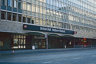
City Thameslink is a central London railway station within the City of London, with entrances on Ludgate Hill and Holborn Viaduct. The station is on the Thameslink route between Blackfriars to the south and Farringdon to the north.

<span class="mw-page-title-main">Holborn Viaduct</span> Road bridge in London

Holborn Viaduct is a road bridge in London and the name of the street which crosses it. It links Holborn, via Holborn Circus, with Newgate Street, in the City of London, England financial district, passing over Farringdon Street and the subterranean River Fleet. The viaduct spans the steep-sided Holborn Hill and the River Fleet valley at a length of 1,400 feet (430 m) and 80 feet (24 m) wide. City surveyor William Haywood was the architect and the engineer was Rowland Mason Ordish.

<span class="mw-page-title-main">Holborn Viaduct railway station</span> Closed London railway station

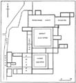
Holborn Viaduct was a railway station in the City of London, providing local and commuter services. It was located to the southeast of Holborn Viaduct, and east of Farringdon Street.

Montfichet's Tower was a Norman fortress on Ludgate Hill in London, between where St Paul's Cathedral and City Thameslink railway station now stand. First documented in the 1130s, it was probably built in the late 11th century. The defences were strengthened during the revolt of 1173–1174 against Henry II.

<span class="mw-page-title-main">A201 road</span> Road in Central London

The A201 is an A road in London, England running from Kings Cross to Bricklayer's Arms.

Blackfriars, derived from Black Friars, a common name for the Roman Catholic Dominican Order of friars, may refer to:

<span class="mw-page-title-main">St Ann Blackfriars</span> Church in England

St Ann Blackfriars was a church in the City of London, in what is now Ireland Yard in the ward of Farringdon Within. The church began as a medieval parish chapel, dedicated to St Ann, within the church of the Dominicans. The new parish church was established in the 16th century to serve the inhabitants of the precincts of the former Dominican monastery, following its dissolution under King Henry VIII. It was near the Blackfriars Theatre, a fact which displeased its congregation. It was destroyed in the Great Fire of London of 1666.

<span class="mw-page-title-main">Derby Blackfriars</span>

Derby Black Friary, also known as Derby Dominican Priory, or Blackfriars, Derby, was a Dominican priory situated in the town of Derby, England. It was also named in different sources as a friary, monastery and convent, but was officially a priory as it was headed by a prior. The "Black" came from the colour of the mantles worn by the friars of the order.

Blackfriars, Thetford was a friary in Norfolk, England, which belonged to the Dominican Order. It was one of several religious houses in Thetford closed at the time of the Dissolution of the Monasteries. The site is now occupied by Thetford Grammar School.

<span class="mw-page-title-main">Ipswich Blackfriars</span> Church in Suffolk, England

Ipswich Blackfriars was a medieval religious house of Friars-preachers (Dominicans) in the town of Ipswich, Suffolk, England, founded in 1263 by King Henry III and dissolved in 1538. It was the second of the three friaries established in the town, the first being the Greyfriars, a house of Franciscan Friars Minors, and the third the Ipswich Whitefriars of c. 1278–79. The Blackfriars were under the Visitation of Cambridge.

Whitefriars is an area in the Ward of Farringdon Without in the City of London. Until 1540, it was the site of a Carmelite monastery, from which it gets its name.

<span class="mw-page-title-main">Holborn Viaduct–Herne Hill line</span>

The Holborn Viaduct–Herne Hill line is a railway line between Holborn Viaduct in the City of London and Herne Hill in the London Borough of Lambeth. After the closure of Holborn Viaduct station the line ends at the south portal of Snow Hill tunnel merging into Snow Hill lines. From there the Widened Lines to St Pancras and Kentish Town are reached. Today the section north of Blackfriars is part of the Thameslink core. Originally being a branch line of the London, Chatham and Dover Railway (LCDR) towards the City of London, the line is sometimes called LCDR City Branch.

References

  1. Holder, Nick (2017). The Friaries of Medieval London: From Foundation to Dissolution. Woodbridge: Boydell. pp. 27–56. ISBN   9781783272242. Archived from the original on 20 June 2018. Retrieved 27 November 2017.
  2. "Explore georeferenced maps - Map images - National Library of Scotland".
  3. https://www.imdb.com/search/title?locations=Blackfriars,%20London,%20England,%20UK Internet Movie Database: search by location Blackfriars, London, England [ user-generated source ]
  4. Francis Erlington Ball 'History of Dublin'

Further reading