
Puddle Dock is a street in Blackfriars in the City of London. It was once the site of one of London's docks, and was later the site of the Mermaid Theatre. The dock was filled in during redevelopment in the 1960s and 1970s.
Puddle Dock is a street in Blackfriars in the City of London. It was once the site of one of London's docks, and was later the site of the Mermaid Theatre. The dock was filled in during redevelopment in the 1960s and 1970s.

Berkeley's Inn, the town house of the Barons Berkeley of Berkeley Castle, Gloucestershire, stood nearby, at the south end of Adle Street, against 'Puddle Wharf', as reported in 1598 by John Stow in his Survey of London, at which date the house had been abandoned by the family and had been split up into multiple-occupation apartments, in a dilapidated state. Richard de Beauchamp, 13th Earl of Warwick, son-in-law of Thomas de Berkeley, 5th Baron Berkeley, lodged in this house, in the parish of St. Andrew-by-the-Wardrobe. [1]
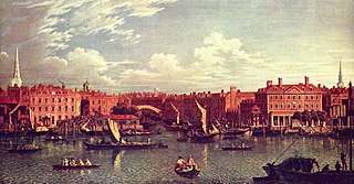
In an article on Puddle Dock by Charles White in 1920 [2] he describes it thus: Puddle Dock is situated at the Western extremity of Upper Thames Street, near our Blackfriars station. It is a square opening in the river bank, between two blocks of warehouses, a place where the dark, drift-strewn waters of the Thames flow right up to the streets of the City. Barges still put in here to discharge their cargoes, as they have done for many centuries. It is the smallest of the draw-docks of Thames-street, the quayside of old London and the germ of what is now the greatest of the world's ports.
Charles White notes that in the deed relating to the sale of the remains of nearby Baynard's Castle in 1275, the sale also includes all other things belonging to the said castle, or barony, as well in rents, his ports and putting in of ships. He suggests that this is Puddle Dock, and is the same dock referred to as wharf at Castle Baynard in Liber Albus and other city archives. He points out that the present Castle Baynard wharf in Thames Street dates back no more than 2 centuries or so, and the so-called Castle Baynard that stood there has no connection with the original Castle Baynard built by William the Conqueror. Recent studies tend to support this view with Puddle Dock found to lie "within the south-eastern corner of the outer defences of the Baynard's Castle" according to a 1989 study. [3]
There is an indirect link to Shakespeare, as he gifted in his will a house to his daughter, Susanna Hall, a house described in the conveyance as "abutting upon a streete leading down to Puddle Wharffe on the east part, right against the King's Majesty's Wardrobe ... now or late in the tenure of one William Ireland or of his asignee or assignees." [4]
Puddle Dock suffered a major fire in 1841 causing "utter destruction to the large bonded warehouses and stores belonging to Messrs Smith & Co, corn factors, situated near Puddle Dock". [5] The warehouse facing the Thames was 7 stories high, and "the principal front fell with a tremendous crash into the river, about 5 o'clock in the morning."
Puddle Dock appeared to be one of the outlets for the London sewers before the great Victorian reforms in that area with numerous complaints in the 1830s, and in 1849 an account stated that "in the course of mid-day, not only waggons arrived loaded with putrid filth, but bones in the worst state of decomposition". [6] However Puddle Dock wasn't alone on this and in complaints in 1849 in relation to raw sewage mentions "Puddle Dock, Whitefriars Dock, Broken Dock and other parts of the shores on the Thames within the City, where the contents of the sewers are discharged". [7]
In 1852 Puddle Dock was mentioned all over the country in an advertisement about the application of sewer treatment to the sewer in Puddle Dock from 1849, which it claims permitted " the conversion of the sewage into dry manure, postable in sacks and perfectly inodorous". [8] After then the dock gets very little mention in the newspapers.
In 1872 there was another major fire at the City Flour Mills built on the "Old Puddle Dock". [9] The building is described as "the largest flour mill in the world", and was 250 feet long, 60 feet wide and 8 stories high. It was owned by Messrs J & J Hadley, who had built the premises in 1852 on a vacant piece of land stretching to the riverside, and within it there were steam powered grinding mills as well as a large grain store. [10]
In 1909 it was reported that the wardsmen of Castle Baynard had been petitioning to fill the dock in. [4]
The Mermaid Theatre was opened in 1959 in a bombed out warehouse alongside Puddle Dock, and the dock was still usable after this, with the Thames sailing barge Henry visible in postcards of the theatre from around 1960. The redevelopment of the area was a protracted affair, with Simon Jenkins of the Illustrated London News commenting in 1971, [11] of the "Blight around Blackfriars" with the destruction of the Gothic and renaissance warehouses. He refers to the barge that was in the Puddle Dock "just 10 years" ago alongside the Mermaid Theatre, which is now "an underpass slip-road".[ citation needed ]
The area was dramatically altered by major works over a long period of time from in the 1960s and early 1970s, involving the reclaiming of foreshore of the River Thames at Puddle Dock and the rebuilding of Upper Thames Street as a major traffic thoroughfare. Today its name survives as the name of a street connecting Upper Thames Street and Queen Victoria Street.[ citation needed ]
Puddle Dock formed part of the marathon course of the 2012 Olympic and Paralympic Games.[ citation needed ]
The nearest London Underground stations are Blackfriars (Circle and District lines) and St Paul's (Central line).
The River Fleet is the largest of London's subterranean rivers, all of which today contain foul water for treatment. It has been used as a culverted sewer since the development of Joseph Bazalgette's London sewer system in the mid-19th century with the water being treated at Beckton Sewage Treatment Works. Its headwaters are two streams on Hampstead Heath, each of which was dammed into a series of ponds—the Hampstead Ponds and the Highgate Ponds—in the 18th century. At the southern edge of Hampstead Heath these descend underground as sewers and join in Camden Town. The waters flow 4 miles (6 km) from the ponds.

Sir Joseph William BazalgetteCB was an English civil engineer. As Chief Engineer of London's Metropolitan Board of Works, his major achievement was the creation of a sewerage system for central London, in response to the Great Stink of 1858, which was instrumental in relieving the city of cholera epidemics, while beginning to clean the River Thames. He later designed Hammersmith Bridge.

The Limehouse Cut is a largely straight, broad canal in the East End of London which links the lower reaches of the Lee Navigation to the River Thames. Opening on 17 September 1770, and widened for two-way traffic by 1777, it is the oldest canal in the London area. Although short, it has a diverse social and industrial history. Formerly discharging directly into the Thames, since 1968 it has done so indirectly by a connection through Limehouse Basin.

The London sewer system is part of the water infrastructure serving London, England. The modern system was developed during the late 19th century, and as London has grown the system has been expanded. It is currently owned and operated by Thames Water and serves almost all of Greater London.

St Andrew-by-the-Wardrobe is a Church of England church located on Queen Victoria Street, London in the City of London, near Blackfriars station.
Blackfriars is in central London, specifically the south-west corner of the City of London.

Baynard's Castle refers to buildings on two neighbouring sites in the City of London, between where Blackfriars station and St Paul's Cathedral now stand. The first was a Norman fortification constructed by Ralph Baynard, 1st feudal baron of Little Dunmow in Essex, and was demolished by King John in 1213. The second was a medieval palace built a short distance to the south-east and later extended, but mostly destroyed in the Great Fire of London in 1666. According to Sir Walter Besant, "There was no house in [London] more interesting than this".

The River Neckinger is a reduced subterranean river that rises in Southwark and flows approximately 2.5 kilometres through south London to St Saviour's Dock where it enters the Thames. What remains of the river is enclosed and runs underground and most of its narrow catchment has been diverted into other combined and surface water sewers, flowing into the Southern Outfall Sewer and the Thames, respectively.

Shad Thames is a historic riverside street next to Tower Bridge in Bermondsey, London, England, and is also an informal name for the surrounding area. In the 19th century, the area included the largest warehouse complex in London.

The Mermaid Theatre was a theatre encompassing the site of Puddle Dock and Curriers' Alley at Blackfriars in the City of London, and the first built in the City since the time of Shakespeare. It was, importantly, also one of the first new theatres to abandon the traditional stage layout; instead of this, a single tier of seats surrounded the stage on three sides.
The Tideway is the part of the River Thames in England which is subject to tides. This stretch of water is downstream from Teddington Lock. The Tideway comprises the upper Thames Estuary including the Pool of London.
Montfichet's Tower was a Norman fortress on Ludgate Hill in London, between where St Paul's Cathedral and City Thameslink railway station now stand. First documented in the 1130s, it was probably built in the late 11th century. The defences were strengthened during the revolt of 1173–1174 against Henry II.

Grosvenor Canal was a canal in the Pimlico area of London, opened in 1824. It was progressively shortened, as first the railways to Victoria Station and then the Ebury Bridge housing estate were built over it. It remained in use until 1995, enabling barges to be loaded with refuse for removal from the city, making it the last canal in London to operate commercially. A small part of it remains within the Grosvenor Waterside development.

Castle Baynard is one of the 25 wards of the City of London, the historic and financial centre of London, England.

Queenhithe is a small and ancient ward of the City of London, situated by the River Thames and to the south of St. Paul's Cathedral. The Millennium Bridge crosses into the City at Queenhithe.

Queen Victoria Street, named after the British monarch who reigned from 1837 to 1901, is a street in London that runs east by north from its junction with New Bridge Street and Victoria Embankment in the Castle Baynard ward of the City of London, along a section that divides the wards of Queenhithe and Bread Street, then lastly through the middle of Cordwainer ward, until it reaches Mansion House Street at Bank junction. Beyond Bank junction, the street continues north-east as Threadneedle Street which joins Bishopsgate. Other streets linked to Queen Victoria Street include Puddle Dock, Cannon Street, Walbrook and Poultry.
During the 19th century, London grew enormously to become a global city of immense importance. It was the largest city in the world from about 1825, the world's largest port, and the heart of international finance and trade. Railways connecting London to the rest of Britain, as well as the London Underground, were built, as were roads, a modern sewer system and many famous sites.
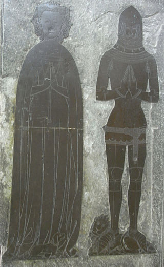
Thomas de Berkeley, 5th Baron Berkeley, The Magnificent, of Berkeley Castle and of Wotton-under-Edge in Gloucestershire, was an English peer and an admiral. His epithet, and that of each previous and subsequent head of his family, was coined by John Smyth of Nibley (d.1641), steward of the Berkeley estates, the biographer of the family and author of "Lives of the Berkeleys".

Baynard House is a brutalist office block in Queen Victoria Street in Blackfriars in the City of London, occupied by BT Group. It was built on the site of Baynard's Castle. Most of the land under it is a scheduled monument. From 1982 to 1997 it housed the BT Museum.