Billingsgate's most ancient historical reference is as a water gate to the city of Trinovantum (the name given to London in medieval British legend), as mentioned in the Historia Regum Britanniae (Eng: History of the Kings of Britain) written c. 1136 by Geoffrey of Monmouth. This work describes how Belinus, a legendary king of Britain said to have held the throne from about 390 BC, erected London's first fortifiedwater gate:
In the town of Trinovantum Belinus caused to be constructed a gateway of extraordinary workmanship, which in his time the citizens called Billingsgate, from his own name. ... Finally, when his last day dawned and carried him away from this life, his body was cremated and the ash enclosed in a golden urn. This urn the citizens placed with extraordinary skill on the very top of the tower in Trinovantum which I have described.[1]
Historical origin
Originally known as Blynesgate and Byllynsgate,[2] its name apparently derives from its origins as a water gate on the Thames, where goods were landed, becoming Billingsgate Wharf, part of London's docks close to Lower Thames Street.
Historian John Stow records that Billingsgate Market was a general market for corn, coal, iron, wine, salt, pottery, fish and miscellaneous goods until the 16th century, when neighbouring streets became a specialist fish market.[3] By the late 16th century, most merchant vessels had become too large to pass under London Bridge, and so Billingsgate, with its deeply recessed harbour, replaced Queenhithe as the most important landing place in the city.
Here, by the permission of Heaven, hell broke loose upon this protestant city, from the malicious hearts of barbarous Papists, by the hand of their agent Hubert, who confessed, and on the ruins of this place declared the fact, for which he was hanged, viz. That here began the dreadful fire, which is described and perpetuated on and by the neighbouring pillar, erected Anno 1680, in the mayoralty of Sir Patience Ward, knight.[5]
After the Great Fire
After the Great Fire of London, shops and stalls set up trade forming arcades on the harbour's west side, whilst on the main quay, an open market soon developed, called "Roomland".
Fish market
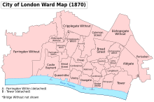
This view by Arnold van Haecken depicts Billingsgate in 1736. It captures the everyday market bustle: featuring fishwives, sailors, porters, thieves, quack-medicine men and casual strollers.The historical extent of the Billingsgate Ward within the City of London
Billingsgate Fish Market was formally established by an act of Parliament in 1699, the Billingsgate, etc. Act 1698 (10 Will. 3. c. 13), to be "a free and open market for all sorts of fish whatsoever".[6]Oranges, lemons, and Spanish onions were also landed there, alongside the other main commodities, coal and salt. In 1849, the fish market was moved off the streets into its own riverside building, which was subsequently demolished (c. 1873) and replaced by an arcaded-market hall (designed by City architect Horace Jones, built by John Mowlem) in 1875.[3]
Legal Quays between Billingsgate Dock and the Tower of London in John Rocque's plan of 1746. Behind Legal Quays lies Thames Street, with its warehouses, sugar refineries and cooperages.
1757 Print by Louis Philippe Boitard, a view of the Legal Quays, between Billingsgate Dock and the Tower. Boitard's engraving, 'Imports from France', provides a satirical look at contemporary Londoners' passion for French luxury goods and manners. By deliberately exaggerating the number of both people and shipping, Boitard's work gives an authentic feel to work on Legal Quays: recording treadwheel cranes, beamscales, Customs’ Officers gauging barrels and porters handling cargo. Smuggling, theft and pilferage of cargoes were rife on both the busy open wharves and in the crowded warehouses.
↑ The name was derived from the butchers in Eastcheap "having their scalding house for hogs there; and their puddings with other filth being conveyed thence down to their dung boats in the Thames": Stow.
This page is based on this Wikipedia article Text is available under the CC BY-SA 4.0 license; additional terms may apply. Images, videos and audio are available under their respective licenses.


