Mark Lane, London

Last updated

Mark Lane
Mark Lane, EC3 - geograph.org.uk - 1093027.jpg
Mark Lane in 2008, viewed from Great Tower Street
Location London, United Kingdom
Postal code EC3
North end Fenchurch Street
South end Great Tower Street

Mark Lane is a street in the City of London linking Great Tower Street and Fenchurch Street. It gave its name to the nearby Mark Lane tube station, which was opened in 1884, renamed Tower Hill in 1964, and closed three years later. For some 240 years, Mark Lane was known for the corn exchange (which was the only market in London for corn, grain and seed); it occupied a series of properties on the east side of the southern end of the street.

Contents

Description

Mark Lane (left) with its nearby station, on an 1888 plan. DISTRICT(1888) p044 - Mark Lane (map).jpg
Mark Lane (left) with its nearby station, on an 1888 plan.

At its northern end, Mark Lane originates as a two-way side-road off Fenchurch Street, leading to Dunster Court, the home of the Worshipful Company of Clothworkers. [1]

The street plays host to a number of offices and restaurants. The nearest London Underground station is Tower Hill (Circle and District lines) and the nearest mainline railway station is Fenchurch Street (with services towards east London and Essex). [2]

Near the northern end of the lane stood the medieval Church of All Hallows Staining, which was demolished in 1870 when its parish was united with nearby St Olave's Church, Hart Street. Only the 12th or 13th century bell tower survives at the junction with Dunster Court. It is a Grade I listed building. [3]

According to the antiquarian John Stow, writing at the end of the 16th century, the name of the lane is derived from a former cattle market or "mart" once held there. [4]

Corn Exchange, London, 1808. Microcosm of London Plate 033 - Corn Exchange.jpg
Corn Exchange, London, 1808.

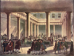
In the nineteenth century 'Mark Lane' was a metonym for London's corn and grain markets. [5] The original London Corn Exchange dated back to 1747. [6] It was designed by George Dance the Elder in the neoclassical style, built around a courtyard which was open to the sky. [7] In 1826 a rival exchange was set up by a group of discontented traders. [8] Permission having been granted by Parliament, they established their new exchange, also in Mark Lane, immediately alongside the old; it was designed by George Smith in the Greek Revival style, and opened in 1828. In 1882, the Old Exchange was largely demolished and replaced by a far larger building, designed by Edward I'Anson in the Italianate style. Both exchanges continued in operation until they were amalgamated in 1926. Smith's New Exchange was demolished five years later; ten years after that, I'Anson's 1882 Corn Exchange was destroyed in the Blitz. Its replacement, by Terence Heysham, was opened in 1952. Twenty years later it too was demolished and rebuilt. [8]

Dornford Yates used Mark Lane as a setting for some of the action in his 1939 thriller, Gale Warning . It is the location of the fictitious "City Conservative Club". [9]

Notable people

See also

Related Research Articles

<span class="mw-page-title-main">Worshipful Company of Clothworkers</span> Livery company of the City of London

The Worshipful Company of Clothworkers was incorporated by Royal Charter in 1528, formed by the amalgamation of its two predecessor companies, the Fullers and the Shearmen. It succeeded to the position of the Shearmen's Company and thus ranks twelfth in the order of precedence of Livery Companies of the City of London.

<span class="mw-page-title-main">Billingsgate</span> Ward of the City of London

Billingsgate is one of the 25 Wards of the City of London. This small City Ward is situated on the north bank of the River Thames between London Bridge and Tower Bridge in the south-east of the Square Mile.

<span class="mw-page-title-main">St Olave's Church, Hart Street</span> Church in London, England

St Olave's Church, Hart Street, is a Church of England church in the City of London, located on the corner of Hart Street and Seething Lane near Fenchurch Street railway station.

<span class="mw-page-title-main">Dunster</span> Human settlement in England

Dunster is a village and civil parish in Somerset, England, within the north-eastern boundary of Exmoor National Park. It lies on the Bristol Channel 2.5 miles (4 km) southeast of Minehead and 20 miles (32 km) northwest of Taunton. At the 2011 Census, it had a population of 817.

<span class="mw-page-title-main">All Hallows Staining</span> Church in United Kingdom

All Hallows Staining was a Church of England church located at the junction of Mark Lane and Dunster Court in the north-eastern corner of Langbourn ward in the City of London, England, close to Fenchurch Street railway station. All that remains of the church is the tower, built around AD 1320 as part of the second church on the site. Use of the grounds around the church is the subject of the Allhallows Staining Church Act 2010.

<span class="mw-page-title-main">Fenchurch Street</span> Street in the City of London

Fenchurch Street is a street in London linking Aldgate at its eastern end with Lombard Street and Gracechurch Street in the west. It is a well-known thoroughfare in the City of London financial district and is the site of many corporate offices and headquarters. The name "Fenchurch" means "church in the fenny or marshy ground" and presumably refers to St Gabriel Fenchurch, which stood at the junction of Fenchurch Street and Cullum Street until it was destroyed by the Great Fire.

<span class="mw-page-title-main">30 Fenchurch Street</span>

30 Fenchurch Street is one of the largest office developments in the City of London, the primary financial district of London. Until October 2020, the building was known as Plantation Place, taking its name from a previous Plantation House, once the world's recognised centre of the tea trade.

<span class="mw-page-title-main">St Benet Gracechurch</span> Church in London, England

St Benet Gracechurch, so called because a haymarket existed nearby (Cobb), was a parish church in the City of London. First recorded in the 11th century, it was destroyed in the Great Fire of London of 1666 and rebuilt by the office of Sir Christopher Wren. The church was demolished in 1868.

<span class="mw-page-title-main">Worshipful Company of Parish Clerks</span> Guild of the City of London

The Worshipful Company of Parish Clerks is one of the Guilds of the City of London. It has no livery, because "in the 16th century, the Parish Clerks declined to take the Livery on the grounds that the surplice was older than the Livery and was the proper garb of members of the Company." It is not, therefore, technically a livery company although to all intents and purposes it acts as such. It is one of two such historic companies without livery, the other being the Company of Watermen and Lightermen.

<span class="mw-page-title-main">Langbourn</span> Ward of the City of London

Langbourn is one of the 25 ancient wards of the City of London. It reputedly is named after a buried stream in the vicinity.

<span class="mw-page-title-main">St Dionis Backchurch</span> Former church-site in London

St Dionis Backchurch was a parish church in the Langbourn ward of the City of London. Of medieval origin, it was rebuilt after the Great Fire of London to the designs of Christopher Wren and demolished in 1878.

<span class="mw-page-title-main">Tower (ward)</span> Ward of the City of London

Tower is one of the 25 wards of the City of London and takes its name from its proximity to the Tower of London. The ward covers the area of the City that is closest to the Tower.

<span class="mw-page-title-main">Great Tower Street</span> Street in the City of London

Great Tower Street, originally known just as Tower Street, is a street in the City of London, the historic nucleus and modern financial centre of London. It forms an eastern continuation of Eastcheap starting at Idol Lane, and leads towards Byward Street and Tower Hill. On Byward Street, opposite Great Tower Street, is the historic church All Hallows-by-the-Tower.

<span class="mw-page-title-main">Lombard Street, London</span> Street in the City of London

Lombard Street is a street notable for its connections with the City of London's merchant, banking and insurance industries, stretching back to medieval times.

<span class="mw-page-title-main">All Hallows, Bow</span> Church in PN, United Kingdom

All Hallows, Bow, is an Anglican church in Bow, London, England. It is within the Diocese of London.

This is a list of the etymology of street names in the City of London.

<span class="mw-page-title-main">Corn exchanges in England</span> Commodity trading halls in Great Britain

Corn exchanges are distinct buildings which were originally created as a venue for corn merchants to meet and arrange pricing with farmers for the sale of wheat, barley, and other corn crops. The word "corn" in British English denotes all cereal grains, such as wheat and barley. With the repeal of the Corn Laws in 1846, a large number of corn exchanges were built in England, particularly in the corn-growing areas of Eastern England.

<span class="mw-page-title-main">Seething Lane</span> Street in the City of London, England

Seething Lane is a street in the City of London. It connects All Hallows-by-the-Tower, Byward Street, with St Olave's Church, Hart Street. The street is named after an Old English expression meaning "full of chaff", which was derived from the nearby corn market in Fenchurch Street. Samuel Pepys lived there and is buried in St Olave's Church at the junction with Hart Street. A bust of Pepys, created by Karin Jonzen, sits in the public garden at the south end of the street.

<span class="mw-page-title-main">Corn Exchange, London</span> Commercial building in London, England

The Corn Exchange was a commercial building in Mark Lane, London, England. The original structure dated from 1747, but the exchange later amalgamated with a rival exchange and was rebuilt several times before finally closing in 1987.

References

  1. "Clothworkers'; Hall at Dunster Court" (PDF). Worshipful Company of Clothworkers. Retrieved 23 May 2023.
  2. Historic England. "Front block of Fenchurch Street Station (1079149)". National Heritage List for England . Retrieved 23 May 2023.
  3. Historic England. "Tower and remains of Church of All Hallows Staining (1064605)". National Heritage List for England . Retrieved 5 October 2021.
  4. "Mark Lane". mapoflondon.uvic.ca. University of Victoria. Retrieved 5 October 2021.
  5. 'The Leisure Hour', 1856, quoted in victorianlondon.org.
  6. Halliday, Stephen (2014). London's Markets: From Smithfield to Portobello Road. The History Press. ISBN   978-0752497396.
  7. Bradley & Pevsner (1997). The Buildings of England: London 1 - The City of London. New Haven and London: Yale.
  8. 1 2 "Coal Exchange Company Ltd". London Metropolitan Archives. City of London. Retrieved 8 February 2017.
  9. Yates, Dornford (2011). Gale Warning. House of Stratus. p. 23. ISBN   978-0755145249.
  10. "Thomas Boddington of Clapton". ucl.ac.uk. Legacies of British Slavery. Retrieved 6 January 2022.
  11. "Alexander Ellice of Mark Lane". ucl.ac.uk. Legacies of British Slavery. Retrieved 29 November 2021.
51°30′37″N0°4′50″W / 51.51028°N 0.08056°W / 51.51028; -0.08056