Brunswick Centre

Last updated

The Brunswick Centre tiered flats, with ventilation towers Brunswick Centre (4136275375).jpg
The Brunswick Centre tiered flats, with ventilation towers

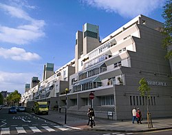
The Brunswick Centre is a grade II listed residential and shopping centre in Bloomsbury, London, England. It is located between Brunswick Square and Russell Square and is administratively in the London Borough of Camden. [1]

Contents

Planning and design

Second floor view of the interior concrete structure Inside the residential area of the estate.jpg
Second floor view of the interior concrete structure

The centre replaced streets of run-down Georgian era terrace housing. [2] It was designed by Patrick Hodgkinson [3] [4] in the mid-1960s, based on studies by Leslie Martin. [5] It was initially planned as a private development at a time when private, mixed-use development in the UK was rare. Building started in 1967 and was completed in 1972, [6] though the building fell some way short of its intended size. The original plan extended up to Euston Road but the Ministry of Defence would not release the site of a building they leased for use by the Territorial Army (and that still stands next to the Centre today).[ citation needed ]

After failing to attract sufficient private buyers on time, the residential section was leased to the London Borough of Camden for use as council housing, while the developer retained ownership of the structure and shopping areas. [ citation needed ] The exterior of the building was never painted [7] because the Borough could not afford to complete work on the building after they took control. In Hodgkinson's design, the blocks would have been painted cream, [8] a shade typical of the Georgian period, as a homage to the terraced houses that previously stood on the site and those that still surround it.[ citation needed ]

21st century

The Renoir cinema Renoir Cinema, The Brunswick Centre - panoramio.jpg
The Renoir cinema
Shopping arcade of The Brunswick in December 2006 BrunswickCentre4.jpg
Shopping arcade of The Brunswick in December 2006

Despite being widely disliked by those who are unsympathetic to modernist architecture[ citation needed ], it was listed Grade II on the National Heritage List for England in 2000. [9] By this time, however, many of its shop premises were unoccupied. Plans for renovation had repeatedly been blocked by residents' committees but in November 2002, the £22 million project began. This included the painting of the blocks in their originally-planned colour and the commissioning of artist Susanna Heron to introduce water features to the central space. [10] [3] The major work was completed in late 2006 [7] with the opening of branches of several high street chain stores and restaurants. [11] The dual management has caused problems though, as the landlord restored the structure of the estate but the council is responsible for maintenance of the residential properties [6] – so while the concrete structure was restored, the windows remained untouched, detracting from the overall aesthetic of the development. In 2007, the council started work on replacing the windows.

Now referring to itself as The Brunswick, the centre contains 560 flats, various shops, cafés and restaurants, a Waitrose supermarket, and a Curzon cinema.

The centre is regularly used as a location for films, [8] TV, photography and music videos including Alexei Sayle's Stuff , The Comic Strip , Crime Traveller , Gangster No. 1 , the BBC's skateboarders trailer and Egg Card's guinea pig advertisement.

See also

Related Research Articles

<span class="mw-page-title-main">London Borough of Croydon</span> London borough in United Kingdom

The London Borough of Croydon is a London borough in south London, part of Outer London. It covers an area of 87 km2 (33.6 sq mi). It is the southernmost borough of London. At its centre is the historic town of Croydon from which the borough takes its name; while other urban centres include Coulsdon, Purley, South Norwood, Norbury, New Addington, Selsdon and Thornton Heath. Croydon is mentioned in Domesday Book, and from a small market town has expanded into one of the most populous areas on the fringe of London. The borough is now one of London's leading business, financial and cultural centres, and its influence in entertainment and the arts contribute to its status as a major metropolitan centre. Its population is 390,719, making it the largest London borough and sixteenth largest English district.

<span class="mw-page-title-main">Bloomsbury</span> District in West End, London

Bloomsbury is a district in the West End of London, part of the London Borough of Camden in England. It is considered a fashionable residential area, and is the location of numerous cultural, intellectual, and educational institutions. Bloomsbury is home of the British Museum, the largest museum in the United Kingdom, and several educational institutions, including University College London and a number of other colleges and institutes of the University of London as well as its central headquarters, the New College of the Humanities, the University of Law, the Royal Academy of Dramatic Art, the British Medical Association and many others. Bloomsbury is an intellectual and literary hub for London, as home of world-known Bloomsbury Publishing, publishers of the Harry Potter series, and namesake of the Bloomsbury Group, a group of British intellectuals which included author Virginia Woolf, biographer Lytton Strachey, and economist John Maynard Keynes.

<span class="mw-page-title-main">Kentish Town</span> Area of London

Kentish Town is an area of northwest London, England in the London Borough of Camden, immediately north of Camden Town. Less than four miles north of central London, Kentish Town has good transport connections and is situated close to the open spaces of Hampstead Heath.

<span class="mw-page-title-main">Camden Town</span> Inner city district of London, England

Camden Town, often shortened to Camden, is an area in the London Borough of Camden, around 2.5 miles (4.1 km) north-northwest of Charing Cross. Historically in Middlesex, it is identified in the London Plan as one of 34 major centres in Greater London.

<span class="mw-page-title-main">Islington</span> District of London, England

Islington is a district in the north of Greater London, England, and part of the London Borough of Islington. It is a mainly residential district of Inner London, extending from Islington's High Street to Highbury Fields, encompassing the area around the busy High Street, Upper Street, Essex Road, and Southgate Road to the east.

<span class="mw-page-title-main">Centre Point</span> Building in Central London, England

Centre Point is a building in Central London, comprising a 34-storey tower; a 9-storey block to the east including shops, offices, retail units and maisonettes; and a linking block between the two at first-floor level. It occupies 101–103 New Oxford Street and 5–24 St Giles High Street, WC1, with a frontage also to Charing Cross Road, close to St Giles Circus and almost directly above Tottenham Court Road tube station. The site was once occupied by a gallows, and the tower sits directly over the former route of St Giles High Street, which had to be re-routed for the construction.

<span class="mw-page-title-main">New Kent Road</span> Road in Southwark, London, England

New Kent Road is a 1 kilometre (0.6 mi) road in the London Borough of Southwark. The road was created in 1751 when the Turnpike Trust upgraded a local footpath. This was done as part of the general road improvements associated with the creation of Westminster Bridge; in effect it was possible to travel from the West End/ Westminster to the south-east without having to go via the Borough of Southwark but could now cross St George's Fields to the junction of Newington Causeway and Newington Butts which is where New Kent Road starts at Elephant & Castle. The route runs eastward for a few hundred yards to the junction of Great Dover Street and Tower Bridge Road, known as Bricklayers Arms, where it joins the original route to the south-east Old Kent Road.

<span class="mw-page-title-main">Shepherd's Bush</span> Suburb of West London, England

Shepherd's Bush is a suburb of West London, England, within the London Borough of Hammersmith and Fulham 4.9 miles (7.9 km) west of Charing Cross, and identified as a major metropolitan centre in the London Plan.

<span class="mw-page-title-main">Knowle, West Midlands</span> Human settlement in England

Knowle is a large village situated 3 miles (5 km) east-southeast of the town of Solihull, West Midlands, England. Knowle lies within the Arden area of the historic county boundaries of Warwickshire, and since 1974 it has been part of the Metropolitan Borough of Solihull within the West Midlands. It lies 2.5 miles from the Warwickshire border and had a recorded population of 10,678.

<span class="mw-page-title-main">Denys Lasdun</span> English architect

Sir Denys Louis Lasdun, CH, CBE, RA was an eminent English architect, the son of Nathan Lasdun (1879–1920) and Julie. Probably his best known work is the Royal National Theatre, on London's South Bank of the Thames, which is a Grade II* listed building and one of the most notable examples of Brutalist design in the United Kingdom.

<span class="mw-page-title-main">Kensington High Street</span> Main shopping street in Kensington, London

Kensington High Street is the main shopping street in Kensington, London, England. The area is identified in the London Plan as one of 35 major centres in Greater London.

<span class="mw-page-title-main">Sutton, London</span> Suburb of London

Sutton is a town in the London Borough of Sutton in South London, England. It is the administrative headquarters of the Outer London borough, on the lower slopes of the North Downs. It is 10 miles (16 km) south-southwest of Charing Cross, one of the thirteen metropolitan centres in the London Plan. The population of the town was counted as 41,483 in the 2011 census, while the borough overall counted 204,525.

<span class="mw-page-title-main">Swiss Cottage Library</span> Library in Camden, London

Swiss Cottage Library is a public library in the London Borough of Camden housed in an architectural landmark building on Avenue Road. Designed by Sir Basil Spence of Spence, Bonnington & Collins, it was built between 1963 and 1964.

<span class="mw-page-title-main">O2 Centre</span> Shopping and entertainment centre on Finchley Road, London

The O2 Centre is an indoor shopping and entertainment centre that is open for around 18 hours per day located on Finchley Road in North West London, near Hampstead, England.

<span class="mw-page-title-main">Golders Green Hippodrome</span> Theatre in London

The Golders Green Hippodrome was built in 1913 by Bertie Crewe as a 3,000-seat music hall, to serve North London and the new London Underground Northern line expansion into Golders Green in the London Borough of Barnet, London, England.

<span class="mw-page-title-main">Denmark Street</span> Street in London

Denmark Street is a street on the edge of London's West End running from Charing Cross Road to St Giles High Street. It is near St Giles in the Fields Church and Tottenham Court Road station. The street was developed in the late 17th century and named after Prince George of Denmark. Since the 1950s it has been associated with British popular music, first via publishers and later by recording studios and music shops. A blue plaque was unveiled in 2014 commemorating the street's importance to the music industry.

<span class="mw-page-title-main">Chester Terrace</span> Terrace in Regents Park, London

Chester Terrace is one of the neo-classical terraces in Regent's Park, London. The terrace has the longest unbroken facade in Regent's Park, of about 280 metres (920 ft). It takes its name from one of the titles of George IV before he became king, Earl of Chester. It now lies within the London Borough of Camden.

<span class="mw-page-title-main">Alexandra Road Estate</span> Housing estate in the London Borough of Camden

The Alexandra Road estate is a housing estate in the London Borough of Camden, North West London, England. It was designed in a brutalist style in 1968 by Neave Brown of Camden Council's Architects Department. Construction work commenced in 1972 and was completed in 1978. It is constructed from site-cast, board-marked white, unpainted reinforced concrete. Along with 520 apartments, the site also includes a school, community centre, youth club, heating complex, and parkland.

<span class="mw-page-title-main">Cleveland Street, London</span>

Cleveland Street in central London runs north to south from Euston Road (A501) to the junction of Mortimer Street and Goodge Street. It lies within Fitzrovia, in the W1 post code area. Cleveland Street also runs along part of the border between Bloomsbury (ward) which is located in London Borough of Camden, and West End (ward) in the City of Westminster. In the 17th century, the way was known as the Green Lane, when the area was still rural, or Wrastling Lane, after a nearby amphitheatre for boxing and wrestling.

<span class="mw-page-title-main">Susanna Heron</span>

Susanna Heron hon FRIBA is a British site-specific artist recognised for her work in stone relief. Her best known works include Stone Drawing for St John's College, Oxford, completed in 2019, and Henslow's Walk at Sainsbury Laboratory, University of Cambridge, winner of the Stirling Prize 2012.

References

  1. Davis, Maggie (17 October 2006). "Brunswick Centre". Timeout.com. Archived from the original on 14 October 2012. Retrieved 16 August 2013.
  2. Rose, Steve (23 October 2006). "Scrubs up beautifully". The Guardian. Retrieved 4 January 2019.
  3. 1 2 "Architecture & Design". Blueprint Magazine. 4 September 2006. Archived from the original on 4 September 2013. Retrieved 16 August 2013.
  4. "Patrick Hodgkinson (1930-2016)".
  5. Property (24 October 2006). "Bloomsbury set to turn a new page". The Daily Telegraph. Archived from the original on 12 November 2012. Retrieved 16 August 2013.
  6. 1 2 "Brunswick Centre | London | The Academy of Urbanism". 5 March 2018.
  7. 1 2 Rose, Steve (23 October 2006). "Steve Rose on the renaissance of the Brunswick Centre". the Guardian.
  8. 1 2 Lovatt, Jane (23 March 2003). "Interiors: The Brunswick Centre". the Guardian.
  9. Historic England, "1-187a O'Donnell Court, 1-212a Foundling Court, Renoir Cinema, shops (The Brunswick Centre), basement car park, and attached ramps, steps and studios (1246230)", National Heritage List for England , retrieved 9 March 2020
  10. "Susanna Heron". Susanna Heron. 27 March 2007. Retrieved 16 August 2013.
  11. "Brunswick Centre Flats Prone To Flooding". Londonist. 10 March 2010.
  12. "London's Top Brutalist Buildings". 24 May 2012.

Further reading

Elain Harwood, A Guide to Post-War Listed Buildings, B.T. Batsford and English Heritage, 2003.

Commons-logo.svg Media related to Brunswick Centre at Wikimedia Commons

51°31′26″N0°07′26″W / 51.524°N 0.124°W / 51.524; -0.124