| | |
 | |
 | |
| Location | Hammersmith, London, England |
|---|---|
| Opening date | 1994 |
| No. of stores and services | 47 |
| Public transit access | |
| Website | hammersmithbroadway |
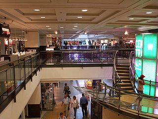
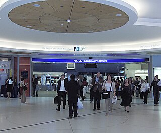
Hammersmith Broadway is a major transport node and shopping centre in Hammersmith, London.
| | |
| | |
| | |
| Location | Hammersmith, London, England |
|---|---|
| Opening date | 1994 |
| No. of stores and services | 47 |
| Public transit access | |
| Website | hammersmithbroadway |
Hammersmith Broadway is a major transport node and shopping centre in Hammersmith, London.
The shopping centre opened in 1994, on the site of many now-demolished buildings, including The Clarendon Hotel (a music venue) and Palmers Department Store. [1] The complex was designed by EPR Architects.
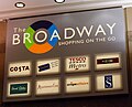
Current tenants include Auntie Anne's, Betfred, Boots, Cards Galore, Costa Coffee, Greggs, Hays plc, Hotel Chocolat, Krispy Kreme, Leon, McDonald's, Pret a Manger, Pure, Scribbler, Starbucks, Supercuts, Superdrug, Tesco, Timpson and Wasabi. [2] [3]
The complex includes a large, modern bus station, spread across two levels. The upper bus station is located directly above the shopping centre, whereas the lower bus station is located at ground level adjacent to the centre.
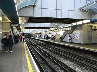
It is also served by two London Underground stations named Hammersmith: The District and Piccadilly lines station is located directly below the shopping centre, with entrances at either end of the centre, while the Circle and Hammersmith & City lines station is located a short distance north of the centre at Beadon Road.


The London Borough of Hammersmith and Fulham is a London borough in West London and which also forms part of Inner London. The borough was formed in 1965 from the merger of the former Metropolitan Boroughs of Hammersmith and Fulham. The borough borders Brent to the north, the Royal Borough of Kensington and Chelsea to the east, Wandsworth to the south, Richmond upon Thames to the south west, and Hounslow and Ealing to the west.

Shepherd's Bush is a district of West London, England, within the London Borough of Hammersmith and Fulham 4.9 miles (7.9 km) west of Charing Cross, and identified as a major metropolitan centre in the London Plan.

South Kensington is a London Underground station in the district of South Kensington, south west London. It is served by the District, Circle and Piccadilly lines. On the District and Circle lines it is between Gloucester Road and Sloane Square, and on the Piccadilly line between Gloucester Road and Knightsbridge. It is in Travelcard Zone 1. The main station entrance is located at the junction of Old Brompton Road (A3218), Thurloe Place, Harrington Road, Onslow Place and Pelham Street. Subsidiary entrances are located in Exhibition Road giving access by pedestrian tunnel to the Natural History, Science and Victoria and Albert Museums. Also close by are the Royal Albert Hall, Imperial College London, the Royal College of Music, the London branch of the Goethe-Institut and the Ismaili Centre.
Hammersmith is a London Underground station in Hammersmith. It is on the District line between Barons Court and Ravenscourt Park, and on the Piccadilly line between Barons Court and Acton Town or Turnham Green at very early morning and late evening hours. The station is in Travelcard Zone 2.

Ealing Common is a London Underground station on the Uxbridge branch of the Piccadilly line and on the Ealing Broadway branch of the District line. Eastbound, the next station is Acton Town; westbound, the next station is North Ealing on the Piccadilly line and Ealing Broadway on the District line. Here, the District and Piccadilly lines share the same pair of tracks through the station – the only other example where a deep level line and a sub surface line share the same pair of tracks is further up the Uxbridge branch, where the Piccadilly line shares tracks with the Metropolitan line from Rayners Lane to Uxbridge. It is the only station west of Acton Town to be served by both the Piccadilly and District lines.
RÉSO, commonly referred to as the Underground City, is the name applied to a series of interconnected office towers, hotels, shopping centres, residential and commercial complexes, convention halls, universities and performing arts venues that form the heart of Montreal's central business district, colloquially referred to as Downtown Montreal. The name refers to the underground connections between the buildings that compose the network, in addition to the network's complete integration with the city's entirely underground rapid transit system, the Montreal Metro. Moreover, the first iteration of the Underground City was developed out of the open pit at the southern entrance to the Mount Royal Tunnel, where Place Ville Marie and Central Station stand today.

Goldhawk Road is a London Underground station located in the London Borough of Hammersmith and Fulham, on the south side of Goldhawk Road, about 250 metres (820 ft) west of Shepherd's Bush Green. It is served by the Circle and Hammersmith & City lines in Travelcard Zone 2.

Shepherd's Bush is a London Underground station in the district of Shepherd's Bush in the London Borough of Hammersmith and Fulham. The station is on the Central line, between White City and Holland Park stations, and it lies in Travelcard Zone 2.
Fulham Broadway is a London Underground station on the Wimbledon branch of the District line. It is between West Brompton and Parsons Green stations and is in Travelcard Zone 2. The station is located on Fulham Broadway (A304). It is the nearest station to Stamford Bridge stadium, the home of Chelsea Football Club. The station is in a cutting that was originally open air until it was covered by the 'Fulham Broadway Shopping Centre' development. The line then resurfaces shortly before West Brompton station.

Hammersmith is a London Underground station in Hammersmith. It is the western terminus of the Circle and Hammersmith & City lines. The station is in Travelcard Zone 2.

Hull Paragon Interchange is a transport interchange providing rail, bus and coach services located in the city centre of Kingston upon Hull, England. The G. T. Andrews-designed station was originally named Paragon Station, and together with the adjoining Station Hotel, it opened in 1847 as the new Hull terminus for the growing traffic of the York and North Midland (Y&NMR) leased to the Hull and Selby Railway (H&S). As well as trains to the west, the station was the terminus of the Y&NMR and H&S railway's Hull to Scarborough Line. From the 1860s the station also became the terminus of the Hull and Holderness and Hull and Hornsea railways.

The A219, is a road in West London, England, which connects the A404 Harrow Road in Harlesden to the A24 in South Wimbledon. Running from North to South, it starts near Willesden Junction station, crosses the Grand Union Canal and runs through Shepherd's Bush, Hammersmith and Fulham, crossing the River Thames at Putney Bridge. It continues through Putney and passes Wimbledon Common, and goes through Wimbledon to terminate just after South Wimbledon Underground station at the A24.
Uxbridge Road is the name of the A4020 road in West London. The 12-mile (19 km) route starts at Shepherd's Bush Green and goes west towards Uxbridge. It passes through Acton, Ealing, Hanwell, Southall, Hayes, and Hillingdon.
Westfield London is a large shopping centre in White City, west London, England, developed by the Westfield Group at a cost of £1.6bn, on a brownfield site formerly the home of the 1908 Franco-British Exhibition. The site is bounded by the West Cross Route (A3220), the Westway (A40) and Wood Lane (A219). It opened on 30 October 2008 and became the largest covered shopping development in the capital; originally a retail floor area of 1,600,000 sq ft (150,000 m2), further investment and expansion led to it becoming the largest shopping centre in Europe by March 2018, an area of 2,600,000 sq ft (240,000 m2).

Commercial–Broadway is a rapid transit station complex in Metro Vancouver's SkyTrain system in Vancouver, British Columbia, Canada. It serves an elevated portion of the Expo Line and a below-grade portion of the Millennium Line. It is a major transit hub, with the third-highest number of boardings of any SkyTrain station, and a terminus of the region's busiest bus route, the 99 B-Line.

White City bus station serves the White City area of west London and Westfield London shopping centre.

Hammersmith bus station is located adjacent to the District & Piccadilly and Circle and Hammersmith & City lines London Underground stations in Hammersmith. It is owned and maintained by Transport for London.

Livat Hammersmith is a retail, residential and office complex located off King Street in Hammersmith in the London Borough of Hammersmith and Fulham. Along with the other Livat Centres, it is operated by the Ingka Centres division of INGKA Holding. It was formerly known as the Kings Mall.

The Bandar Utama station is a mass rapid transit (MRT) station serving the suburb of Bandar Utama in Petaling Jaya, Selangor, Malaysia as well as parts of Taman Tun Dr Ismail, Kuala Lumpur which lie across the Damansara–Puchong Expressway from the station.

King Street, Hammersmith is the main shopping street in Hammersmith, London. It runs west–east, and forms part of the A315, and is the eastern continuation of Chiswick High Road, where it meets Goldhawk Road, close to Stamford Brook tube station. At the eastern end it meets Hammersmith Broadway and continues east as Hammersmith Road where it forms a crossroads with the A219, the Shepherd's Bush Road running northwards, and the Fulham Palace Road running south.