Shoreditch

Last updated

Shoreditch
Shoreditch town hall3.jpg
Greater London UK location map 2.svg
Red pog.svg
Shoreditch
Location within Greater London
OS grid reference TQ325825
  Charing Cross 2.5 mi (4.0 km)  WSW
London borough
Ceremonial county Greater London
Region
Country England
Sovereign state United Kingdom
Post town LONDON
Postcode district EC1, EC2
Postcode district E1, E2
Dialling code 020
Police Metropolitan
Fire London
Ambulance London
UK Parliament
London Assembly
List of places
UK
England
London
51°31′34″N0°04′41″W / 51.526°N 0.078°W / 51.526; -0.078

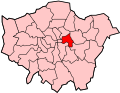
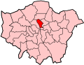
Shoreditch is an area in London, England and is located in the London Borough of Hackney alongside neighbouring parts of Tower Hamlets, which are also perceived as part of the area due to historic ecclesiastical links. Shoreditch lies just north-east of the border with the City of London and is considered to be a part of London's East End.

Contents

In the 16th century, Shoreditch was an important centre of the Elizabethan Theatre, and it has been an important entertainment centre since that time. Today, it hosts many pubs, bars and nightclubs. [1] [2] The most commercial areas lie closest to the city of London and along the A10 Road, with the rest mostly residential. [3]

Toponymy

Early spellings of the name include Soredich (c.1148), Soresdic (1183–4), Sordig (1204), Schoresdich (1220–21), and other variants. [4] [5] Toponymists are generally agreed that the name derives from Old English "scoradīc", i.e. "shore-ditch", the shore being a riverbank or prominent slope; [6] but there is disagreement as to the identity of the "shore" in question. A suggestion made by Eilert Ekwall in 1936 that the "ditch" might have been one leading to the "shore" of the Thames continues to enjoy widespread currency. [7] [8] [9] Other scholars, however, have challenged this interpretation on the grounds that the City of London lies between Shoreditch and the Thames. [5] [10] A variant spelling used by John Stow in 1598, Sewers Ditche, raises the possibility that the name might originally have referred to a drain or watercourse. [11] [12] Certainly the area was once boggy, and the name might bear some relation to the main branch of the Walbrook, which rose in Hoxton, ran along what is now Curtain Road, flowing past the former Curtain Theatre. The river was known in this area as the Deepditch, [13] Flood Ditch or just The Ditch.

Folk etymology holds that the place was originally named "Shore's Ditch", after Jane Shore, the mistress of Edward IV, who is supposed to have died or been buried in a ditch in the area. This legend is commemorated today by a large painting, at Haggerston Branch Library, of the body of Shore being retrieved from the ditch, and by a design on glazed tiles in a shop in Shoreditch High Street showing her meeting Edward IV. [14] However, the area was known as Shoreditch long before Jane Shore lived: the Survey of London , for example, lists some 26 deeds dating from between c.1148 and 1260 which use some version of the name. [4]

In another theory, also now discredited, antiquarian John Weever claimed that the name was derived from Sir John de Soerdich, who was lord of the manor during the reign of Edward III (132777). [15]

History

Origins

Shoreditch church Shoreditch church.jpg
Shoreditch church

Though now part of Inner London, Shoreditch was previously an extramural suburb of the City of London, centred on Shoreditch Church at the old crossroads where Shoreditch High Street and Kingsland Road are crossed by Old Street and Hackney Road.

Shoreditch High Street and Kingsland Road are a small sector of the Roman Ermine Street and modern A10. Known also as the Old North Road, it was a major coaching route to the north, exiting the City at Bishopsgate. The east–west course of Old Street–Hackney Road was also probably originally a Roman Road, connecting Silchester with Colchester, bypassing the City of London to the south. [16]

Shoreditch Church (officially known as St Leonard's, Shoreditch) is of ancient origin. It is featured in the famous line "when I grow rich say the bells of Shoreditch", from the English nursery rhyme "Oranges and Lemons".

Shoreditch was the site of a house of canonesses, the Augustinian Holywell Priory (named after a Holy Well on the site), from the 12th century until its dissolution in 1539. This priory was located between Shoreditch High Street and Curtain Road to east and west, and Batemans Row and Holywell Lane to north and south. Nothing remains of it today. [17]

Shakespeare and the Elizabethan theatre

Memorial to Elizabethan actors buried in Shoreditch church St Leonards Memorial.JPG
Memorial to Elizabethan actors buried in Shoreditch church

In 1574 the City authorities banned the building of playhouses in the City of London area, consequently theatres were built in the suburbs, beyond its jurisdiction. [18]

The first of these came in 1576, when James Burbage built the first playhouse in England, known as "The Theatre", on the site of the Priory (commemorated today by a plaque on Curtain Road, and excavated in 2008, by MoLAS). [19]

William Shakespeare lived nearby in a property overlooking St Helen's churchyard in the Bishopsgate Within area of the City. His early plays were first performed in Shoreditch, at The Theatre and at the nearby Curtain Theatre, built the following year [20] and 200 yards (183 m) to the south (marked by a commemorative plaque in Hewett Street off Curtain Road). Romeo and Juliet was first performed here, gaining "Curtain plaudits", Henry V was performed within "this wooden O" and an early version of Hamlet was also first staged in Shoreditch. [21]

Shakespeare's Company moved the timbers of "The Theatre" to Southwark at the expiration of the lease in 1599, in order to construct the Globe. The Curtain continued performing plays in Shoreditch until at least 1627. [22]

The suburb of Shoreditch was attractive as a location for these early theatres because, like Southwark, it was outside the jurisdiction of the somewhat puritanical City fathers. Even so, they drew the wrath of contemporary moralists, as did the local "base tenements and houses of unlawful and disorderly resort" and the "great number of dissolute, loose, and insolent people harboured in such and the like noisome and disorderly houses, as namely poor cottages, and habitations of beggars and people without trade, stables, inns, alehouses, taverns, garden-houses converted to dwellings, ordinaries, dicing houses, bowling alleys, and brothel houses". [23]

17th and 18th centuries

During the 17th century, wealthy traders and French Huguenot silkweavers moved to the area, establishing a textile industry centred to the south around Spitalfields. By the 19th century, Shoreditch was also the locus of the furniture industry, [24] now commemorated in the Geffrye Museum on Kingsland Road. These industries declined in the late 19th century.

Victorian entertainments

1867 poster from the National Standard Theatre 1867 NationalStandardTheatre.jpg
1867 poster from the National Standard Theatre
1907 Hetty King sheet music, expressing a concern of modern residents HettyKingDark.jpg
1907 Hetty King sheet music, expressing a concern of modern residents

In the 19th and early 20th centuries, Shoreditch was a centre of entertainment to rival the West End and had many theatres and music halls:

None of these places of entertainment survives today. Music hall was revived for a brief time in Curtain Road by the temporary home of the Brick Lane Music Hall. [28] This too has now moved on.

A number of playbills and posters from these music halls survive in the collections of both the Bishopsgate Institute and the Victoria and Albert Museum.

First World War

In the First World War, the Mayor and Borough of Shoreditch raised a pals battalion of volunteers from around the borough who would serve together as the 20th (Shoreditch) Battalion, Middlesex Regiment (Duke of Cambridge's Own). The Middlesex Regiment the battalion belonged to was nicknamed the "Die-hards".

For most of its time in the line, the unit was attached to 118th Brigade, part of the 39th Division. The battalion was involved in many actions on the Western Front in 1916–18. [29]

Inter-war years

Syd's coffee stall was established in Calvert Avenue in 1919 and operated continuously until 2019. [30]

In the 1930s, Shoreditch, Holy Trinity parish united with that of St Leonard. [31]

Second World War

Shoreditch was heavily bombed during the Second World War, with around 495 of its civilian residents killed. [32]

The area was hit by at least 279 high explosive bombs, 6 parachute mines 7 V-1 'doodlebugs', 2 V-2 rockets and many thousands of 1 kg incendiary devices. [33] The destruction of housing and industry caused by the two V-2s contributed to the opportunity to create Shoreditch Park and Haggerston Park.[ citation needed ]

Decline

Shoreditch post-war declined in conditions, as did both textile and furniture industries with competition elsewhere. This situation was exacerbated by the extensive devastation of the housing stock in the Blitz during the Second World War, and by insensitive redevelopment in the post-war period.[ citation needed ]

A south-west to north-east tube line called the Chelsea-Hackney line was proposed in 1970 by the then London Transport Board's London Rail Study as the next project after the completion of the Victoria line and the Fleet line (now the Jubilee line) but was not carried forward, it would have had a new tube station near Shoreditch Church if it was built. [34]

Contemporary

A coffee shop in Boxpark Shoreditch Guardiancoffee-boxpark.jpg
A coffee shop in Boxpark Shoreditch

Formerly a predominantly working-class area, since around 1996 Shoreditch has become a popular and fashionable part of London, particularly associated with the creative industries. Often conflated with its neighbouring sub-district of Hoxton, the area has been subject to considerable gentrification, with accompanying rises in land and property prices.[ citation needed ]

Former industrial buildings have been converted to offices and flats, while Curtain Road and Old Street are notable for their clubs and pubs which offer a variety of venues to rival those of the West End. Art galleries, bars, restaurants, media businesses and the building of the Hackney Community College campus are features of this transformation.[ citation needed ]

In the mid-1960s, the main streets of Shoreditch (Old Street, Shoreditch High Street and Curtain Road, Great Eastern Street) were formed into a one-mile-long (1.5-kilometre) one-way system, which became associated with traffic congestion, poor conditions for walking and cycling, high speeds, high collision rates, and delays for bus services. The gyratory system came to be seen as "the main factor holding back the cultural regeneration of South Shoreditch" [35] and "a block to economic recovery". [36] Following a lengthy campaign, [37] the then newly formed Transport for London agreed to revert most of the streets to two-way working, a project which was completed in late 2002.

Shoreditch High Street railway station, built as part of the East London Line extension. Shoreditch High Street stn entrance2 April2010.jpg
Shoreditch High Street railway station, built as part of the East London Line extension.

In 2005, funding was announced for the East London Line Extension, to extend the existing tube line from Whitechapel tube station bypassing Shoreditch tube station, and to create a new station named Shoreditch High Street closer to central Shoreditch. This is now served by London Overground services on part of the site of the old Bishopsgate Goods Yard, which was demolished in 2004. [38] [39] The station was built on a viaduct and is fully enclosed in a concrete box structure. This is so future building works on the remainder of the Bishopsgate site can be undertaken keeping the station operational. [38] [39]

Tower Hamlets Council made proposals to transfer the Boundary Estate to a housing association and upgrade the accommodation in 2006. A full refurbishment of one of the blocks, Iffley House was carried out by Sprunt Architects to demonstrate how this might be achieved but the proposal was rejected by a ballot of tenants in November of that year. [40]

More recently, during the second "dot-com" boom, both the area and Old Street have become popular with London-based web technology companies who base their head offices around the East London Tech City district. These include Last.fm, Dopplr, Songkick, SocialGO and 7digital. These companies have tended to gravitate towards Old Street Roundabout, giving rise to the term "Silicon Roundabout" to describe the area, as used by Prime Minister David Cameron in a speech in November 2010. [41]

As a result, the name of Shoreditch has become synonymous with the concept of contemporary "hipsterfication" of regenerated urban areas. As a pioneer among similar transformations across the UK, various phrases have been coined, from "Shoreditchification" to "Very Shoreditch". [42]

In 2014, the Boundary Estate and the nearby area came under the East Shoreditch Neighbourhood Forum. Forum status ceased to have effect on 5 February 2019 but the Neighbourhood Area designation is unaffected by the expiry. [43]

The Stag's Head public house was Grade II listed in 2015 by Historic England. [44]

South Shoreditch undergoing reconstruction in 2015 SouthShoreditch.JPG
South Shoreditch undergoing reconstruction in 2015

South Shoreditch has undergone an enormous transformation. Several five- or six-storey buildings have been knocked down in the area of Shoreditch that borders the City of London. In their place will be erected a variety of very tall buildings, mirroring the architectural styles in the City. [45] The developments will result in more residential units being available for sale in Shoreditch than were produced by the Olympics athletes' village. [45]

One landmark development is the Principal Tower in Worship Street, designed by the architects Foster and Partners, [46] and next to it is Principal Place, also designed by Foster and Partners. In July 2014, it was reported that the internet retailer Amazon.com was close to signing a lease to move its UK headquarters there. The project had been on hold since January 2012, when the anchor tenant, the law firm CMS Cameron McKenna pulled out. Soon after, the developer Hammerson sold its interest in the scheme to Brookfield. [47]

There has been some consideration of creating an interchange with the Central line between Liverpool Street and Bethnal Green at Shoreditch High Street, where the line runs almost underneath the station. However, this could not be seriously contemplated before the completion of the Crossrail project, owing to extreme crowding on the Central line during peak hours. [48] [49]

London Overground began running 24-hour trains on Friday and Saturday nights between Dalston Junction and New Cross Gate which called at Shoreditch High Street from 15 December 2017. [50] but bypasses Whitechapel and continues on to Shadwell due to ongoing Crossrail construction work for (Elizabeth line) until 2019. [51]

Two Huguenot workers' houses on Club Row on the corner of Redchurch Street, which developers had wished to knock down, were saved from demolition. They were deemed of special historic interest, giving the houses protection from destruction from 2019. [52]

Geography

Shoreditch and surrounding area, 1755. The north-eastern part of the map is part of the parish of Shoreditch 1755 Stow Shoreditch.jpg
Shoreditch and surrounding area, 1755. The north-eastern part of the map is part of the parish of Shoreditch

Shoreditch covers a wide area, but its historic heart lies south of Old Street, around Shoreditch High Street and Shoreditch Church. The districts of Hoxton and Haggerston have been historically part of Shoreditch since the medieval period and occupy the north-west and north-east of Shoreditch respectively; however, their extent has never been formally defined.

Although Shoreditch has been consistently defined, perceptions have blurred in recent years; something that became possible after the Metropolitan Borough of Shoreditch amalgamated with some of its neighbours to become the southern part of the London Borough of Hackney in 1965.

The location of the former Shoreditch tube station (closed 2006), 400 metres outside Shoreditch proper, in nearby Bethnal Green, Tower Hamlets, influenced this shift. Its replacement, Shoreditch High Street station, straddles the borough boundary.

More significant has been the gentrification of the Shoreditch area since the millennium, leading to a marked increase in the area's prestige, which has led businesses in the Bethnal Green and Spitalfields areas of Tower Hamlets to include the name Shoreditch in their company's name and marketing material. This is also seen to a lesser extent in the St Luke's area of the London Borough of Islington.

Administration

A map showing the wards of Shoreditch Metropolitan Borough as they appeared in 1916. Shoreditch Met. B Ward Map 1916.svg
A map showing the wards of Shoreditch Metropolitan Borough as they appeared in 1916.

Shoreditch was an administrative unit with consistent boundaries from the Middle Ages until its merger into the London Borough of Hackney in 1965. Shoreditch was based for many centuries on the Ancient Parish of Shoreditch (St Leonard's), part of the county of Middlesex.

Parishes in Middlesex were grouped into Hundreds, with Shoreditch part of Ossulstone Hundred. Rapid Population growth around London saw the Hundred split into several 'Divisions' during the 1600s, with Shoreditch part of the Tower Division (aka Tower Hamlets). The Tower Division was noteworthy in that the men of the area owed military service to the Tower of London – and had done even before the creation of the Division [53] – an arrangement which continued until 1899.

The Ancient Parishes provided a framework for both civil (administrative) and ecclesiastical (church) functions, but during the nineteenth century there was a divergence into distinct civil and ecclesiastical parish systems. In London the Ecclesiastical Parishes sub-divided to better serve the needs of a growing population, while the Civil Parishes continued to be based on the same Ancient Parish areas.

For civil purposes, the Metropolis Management Act 1855 turned the parish area into a new Shoreditch District of the Metropolis, with the same boundaries as the parish. The London Government Act 1899 converted these areas into Metropolitan Boroughs, again based on the same boundaries, sometimes with minor rationalisations. The Borough's areas of modern Shoreditch, Hoxton and Haggerston were administered from Shoreditch Town Hall, which can still be seen on Old Street. It has been restored and is now run by the Shoreditch Town Hall Trust.

Holy Trinity, Shoreditch in the Old Nichol was for ecclesiastical purposes in Shoreditch from 1866 but was administratively part of Bethnal Green. [54]

In 1965, Shoreditch was merged with Hackney and Stoke Newington to form the new London Borough of Hackney.

Governance

Shoreditch is home to the Baron Wei of Shoreditch, who lives in the area and sits as a Conservative life peer and Lords Temporal as part of the House of Lords. [55] He was introduced on 3 June 2010. [56] [57]

Official portrait of Meg Hillier (MP) of Hackney South and Shoreditch. Official portrait of Meg Hillier crop 2.jpg
Official portrait of Meg Hillier (MP) of Hackney South and Shoreditch.

The Hackney borough part of Shoreditch is part of the Hackney South and Shoreditch constituency, represented in the House of Commons of the UK Parliament since 2005 by Meg Hillier of the Labour Party and of the Co-operative Party

The eastern part of Shoreditch, in Tower Hamlets, lies within the constituency of Bethnal Green and Bow, represented since 2010 by Rushanara Ali of the Labour Party.

Notable local residents

Education

Transport

Rail

Shoreditch High Street station is near Boxpark, on Bethnal Green Road. The station is served by London Overground ( Overground roundel (no text).svg ) trains on the East London line, and is in London fare zone 1. Trains link the area directly to Dalston and Highbury & Islington to the northwest, whilst to the south, trains travel directly to major destinations like Canada Water, Clapham Junction, West Croydon, Crystal Palace, New Cross, Peckham and Whitechapel. Hoxton station is to the north of Shoreditch, on the same line. [60]

There is a nearby Overground ( Overground roundel (no text).svg ) station at Bethnal Green, with services towards Hackney Downs, Seven Sisters, Chingford, Enfield, and Cheshunt. [60]

Liverpool Street ( Central line roundel (no text).svg Circle line roundel (no text).svg H&c line roundel (no text).svg Metropolitan line roundel (no text).svg ) and Old Street ( Northern line roundel (no text).svg ) tube stations are also nearby. Both stations are also on the National Rail network.

Until 2006, Shoreditch tube station was served by London Underground East London line trains. The line and station closed to make way for the London Overground.

Buses

London Buses provides all local bus services across the district: routes 8, 135, 205, 388, N8 and N205 on Great Eastern Street and Bishopsgate; routes 26, 35, 47, 48, 67, 78 and N26 on Shoreditch High Street; and routes 55, 149, 242, 243 and N55 on Old Street. [61] [62] [63]

Cycling

Two Transport for London (TfL) Cycleways pass through Shoreditch.

Cycle Superhighway 1 runs north-south along the western perimeter of the area, through the Old Street junction. The route is signposted, and links the area to Moorgate and Finsbury southbound, and to Dalston, Stoke Newington, and Seven Sisters to the north.

Quietway 13 runs east-west through Shoreditch, primarily on quiet streets. The route is signposted, and runs from Finsbury in the City to the Regent's Canal near Cambridge Heath.

The Regent's Canal towpath runs along the northernmost edge of the district, close to Shoreditch Park. The towpath is a shared-use path for pedestrians and cyclists and runs unbroken from Angel in Islington to Limehouse near Canary Wharf. Eastbound, the path links the area to Victoria Park and Mile End. [64] [65]

The London Cycle Hire Scheme operates in Shoreditch.

See also

Related Research Articles

<span class="mw-page-title-main">Bethnal Green</span> Human settlement in England

Bethnal Green is an area in London, England and is located in the London Borough of Tower Hamlets. It is in East London and part of the East End. The area emerged from the small settlement which developed around the Green, much of which survives today as Bethnal Green Gardens, beside Cambridge Heath Road. By the 16th century the term applied to a wider rural area, the Hamlet of Bethnal Green, which subsequently became a Parish, then a Metropolitan Borough before merging with neighbouring areas to become the north-western part of the new Tower Hamlets.

<span class="mw-page-title-main">London Borough of Hackney</span> London borough in United Kingdom

The London Borough of Hackney is a London borough in Inner London, England. The historical and administrative heart of Hackney is Mare Street, which lies 5 miles (8 km) north-east of Charing Cross. The borough is named after Hackney, its principal district. Southern and eastern parts of the borough are popularly regarded as being part of east London that spans some of the traditional East End of London with the northwest belonging to north London. Its population is 281,120 inhabitants.

<span class="mw-page-title-main">Dalston</span> Area of East London, England

Dalston is an area in London, England and is located in the London Borough of Hackney. It lies in North East London and is four miles northeast of Charing Cross. Dalston began as a hamlet on either side of Dalston Lane, and as the area urbanised the term also came to apply to surrounding areas including Kingsland and Shacklewell, all three of which being part of the Ancient Parish of Hackney.

<span class="mw-page-title-main">Hoxton</span> Neighbourhood in the East End of London, England

Hoxton is an area in the London Borough of Hackney, England, and on the north-western fringes of the East End, the historic core of wider East London. It was historically in the county of Middlesex until 1889. It lies immediately north of the City of London financial district, and was once part of the civil parish and subsequent Metropolitan Borough of Shoreditch, prior to its incorporation into the London Borough of Hackney.

<span class="mw-page-title-main">Stamford Hill</span> Area of Hackney, London

Stamford Hill is an area in Inner London, England, about 5.5 miles north-east of Charing Cross. The neighbourhood is a sub-district of Hackney, the major component of the London Borough of Hackney, and is known for its Hasidic community, the largest concentration of Hasidic Jews in Europe.

<span class="mw-page-title-main">Stepney</span> Human settlement in England

Stepney is an area in London, England and is located in the London Borough of Tower Hamlets. It is in East London and part of the East End. Stepney is no longer officially defined, and is usually used to refer to a relatively small area. However, for much of its history the place name applied to a much larger manor and parish. Stepney Green is a remnant of a larger area of Common Land formerly known as Mile End Green.

<span class="mw-page-title-main">London Borough of Tower Hamlets</span> Borough in London, England

The London Borough of Tower Hamlets is a borough of London, England. Situated on the north bank of the River Thames and immediately east of the City of London, the borough spans much of the traditional East End of London and includes much of the regenerated London Docklands area. The 2019 mid-year population for the borough is estimated at 324,745.

<span class="mw-page-title-main">Bishopsgate</span> Ward of the City of London

Bishopsgate was one of the eastern gates in London's former defensive wall. The gate's name is traditionally attributed to Earconwald, who was Bishop of London in the 7th century. It was first built in Roman times and marked the beginning of Ermine Street, the ancient road running from London to York (Eboracum). The gate was rebuilt twice in the 15th and 18th centuries, but was permanently demolished in 1760.

<span class="mw-page-title-main">Bishopsgate railway station</span> Disused railway station in London, England

Bishopsgate was a railway station located on the eastern side of Shoreditch High Street in the parish of Bethnal Green on the western edge of the East End of London and just outside the City of London.

<span class="mw-page-title-main">Cambridge Heath</span> Human settlement in England

Cambridge Heath is an area in the London Borough of Tower Hamlets, approximately 5.7 km (3.5 mi) north east of Charing Cross. It is named after a former heath in the East End of London. The northern boundary is formed by the Regent's Canal and the area includes Vyner Street, best known for its street art and galleries.

<span class="mw-page-title-main">Hackney Central</span> Human settlement in England

Hackney Central is a sub-district of Hackney in the London Borough of Hackney in London, England and is four miles (6.4 km) northeast of Charing Cross.

<span class="mw-page-title-main">St Leonard's, Shoreditch</span> Church in London Borough of Hackney, United Kingdom

St Leonard's, Shoreditch, is the ancient parish church of Shoreditch, often known simply as Shoreditch Church. It is located at the intersection of Shoreditch High Street with Hackney Road, within the London Borough of Hackney in East London. The current building dates from about 1740 and is Grade I listed. The church is mentioned in the line ""When I grow rich", say the bells of Shoreditch" from the nursery rhyme Oranges and Lemons.

Shoreditch (St Leonard) was an ancient parish in the county of Middlesex. It was both a civil parish, used for administrative purposes, and an ecclesiastical parish of the Church of England. The parish church is St Leonard's, Shoreditch, often simply called "Shoreditch Church".

<span class="mw-page-title-main">Hackney Road</span> London arterial route in the London Boroughs of Hackney and Tower Hamlets

Hackney Road is a London arterial route running from Shoreditch Church in London Borough of Hackney to Cambridge Heath in the London Borough of Tower Hamlets. The route runs along the northern edge of Bethnal Green and southern edge of Haggerston. It lies close to the border between the boroughs of London Boroughs of Hackney and Tower Hamlets.

<span class="mw-page-title-main">Shoreditch High Street railway station</span> London Overground station

Shoreditch High Street is a London Overground station located on Bethnal Green Road in Shoreditch in East London. It is served by the East London Line between Whitechapel and Hoxton with services running either to Dalston Junction, Highbury & Islington or New Cross, New Cross Gate, West Croydon, Crystal Palace, and is in Travelcard Zone 1.

<span class="mw-page-title-main">Shoreditch High Street</span> Street in Shoreditch

Shoreditch High Street is the old main street of Shoreditch, London. It is part of the A10 road and connects Norton Folgate to the south with Kingsland Road to the north. It constitutes a segment of the Roman Ermine Street, which ran directly north from London to Lincoln and York. The parish church of St Leonard's, Shoreditch is situated at the north-east end of the road, at the crossroads where it meets with Hackney Road.

<span class="mw-page-title-main">East End of London</span> Area of London, England

The East End of London, often referred to within the London area simply as the East End, is the historic core of wider East London, east of the Roman and medieval walls of the City of London and north of the River Thames. It does not have universally accepted boundaries to the north and east, though the River Lea is sometimes seen as the eastern boundary. Parts of it may be regarded as lying within Central London. The term "East of Aldgate Pump" is sometimes used as a synonym for the area.

<span class="mw-page-title-main">Columbia Road Flower Market</span> Street market in London

Columbia Road Flower Market is a street market in Bethnal Green in London, England. Columbia Road is a road of Victorian shops situated off Hackney Road in the London Borough of Tower Hamlets. The market is open on Sundays only.

<span class="mw-page-title-main">Liberty of Norton Folgate</span>

Norton Folgate was a liberty in Middlesex, England; adjacent to the City of London in what would become the East End of London.

<span class="mw-page-title-main">Hackney, London</span> Human settlement in England

Hackney is a district in East London, England, forming around two-thirds of the area of the modern London Borough of Hackney, to which it gives its name. It is 4 miles (6.4 km) northeast of Charing Cross and includes part of the Queen Elizabeth Olympic Park. Historically it was within the county of Middlesex.

References

  1. "9: Annex – Delivering Placemaking" (PDF). Local Development Framework (Report). Tower Hamlets. 2009. pp. 99–103. Archived (PDF) from the original on 6 August 2018.
  2. "London's Places" (PDF). London Plan . Greater London Authority. 2011. p. 46. Archived from the original (PDF) on 6 September 2015. Retrieved 27 May 2014.
  3. "Urban Structure and Characterisation Study pages 52-63" (PDF). Archived (PDF) from the original on 28 July 2019. Retrieved 3 May 2020.
  4. 1 2 Bird, James, ed. (1922). "Historical introduction: General". Survey of London: Volume 8, Shoreditch. London: London County Council. pp. 1–5. Retrieved 17 June 2019.
  5. 1 2 Gover, J. E. B.; Mawer, Allen; Stenton, F. M. (1942). The Place-Names of Middlesex apart from the City of London. English Place-Name Society. Vol. 18. Cambridge: Cambridge University Press. pp. 145–46.
  6. "Key to English Place-names". Archived from the original on 7 January 2018. Retrieved 9 January 2019.
  7. Ekwall, Eilert (1936). The Concise Oxford Dictionary of English Place-Names. Oxford: Clarendon Press. p. 399.
  8. Watts, Victor, ed. (2004). The Cambridge Dictionary of English Place-Names. Cambridge: Cambridge University Press. p. 547. ISBN   9780521362092.
  9. Mander 1996, p. 13.
  10. Field, John (1980). Place-Names of Greater London. London: Batsford. p. 85. ISBN   0713425385.
  11. Stow, John (1598). A Survay of London. London. pp. 349–50.
  12. Stow, John (1908) [1603]. Kingsford, Charles Lethbridge (ed.). A Survey of London. Vol. 2. Oxford: Clarendon Press. pp. 73–75.
  13. BHO covers Moorfields and surrounding area https://www.british-history.ac.uk/survey-london/vol8/pp88-90
  14. Clunn, H. P. (1970) The Face of London. Spring Books: London. pp. 312, 493
  15. Timbs, John (1855). Curiosities of London: Exhibiting the Most Rare and Remarkable Objects of Interest in the Metropolis. D. Bogue. p. 729.
  16. Sugden n.d.
  17. Wood 2003.
  18. Clout, Hugh, ed. (1999). The Times History of London. London: Times Books. p. 146. ISBN   9780723010302.
  19. Shakespeare's Shoreditch theatre unearthed Maev Kennedy, The Guardian , Thursday, 7 August 2008
  20. "The Shoreditch You Never Knew – Made in Shoreditch Magazine". 15 September 2014.
  21. "At Shakespeare's Theatre In Shoreditch – Spitalfields Life". spitalfieldslife.com. Retrieved 13 June 2019.
  22. Shapiro 2005.
  23. Middlesex Justices in 1596; cited in Schoenbaum 1987, p. 126.
  24. Cleaver, Naomi (5 August 2005). "Roving eye: Shoreditch" . The Daily Telegraph. Archived from the original on 12 January 2022.
  25. "Shoreditch Theatres and Halls". Arthur Lloyd. Retrieved 4 November 2016.
  26. "Shoreditch Empire" (PDF). Over the Footlights. Archived (PDF) from the original on 19 October 2013. Retrieved 4 November 2016.
  27. Satisfactory turnover The Guardian, London, 28 Feb 1935, p. 14
  28. "Brick Lane Music Hall".
  29. Memorial to the battalion, recorded by IWM https://www.iwm.org.uk/memorials/item/memorial/53140
  30. "New life brewed for 100-year-old coffee stall". BBC News. 19 December 2019. Retrieved 6 January 2020.
  31. https://search.lma.gov.uk/scripts/mwimain.dll/144/LMA_OPAC/web_detail/REFD+P72~2FTRI?SESSIONSEARCH
  32. Commonwealth war graves site https://www.cwgc.org/visit-us/find-cemeteries-memorials/cemetery-details/4004488/SHOREDITCH,%20METROPOLITAN%20BOROUGH/
  33. Detailed Unexploded Ordnance Risk Assessment, by 1st Line Defence, to support the Shoreditch Village planning application
  34. "London Transport plans third new Tube Line". The Times. UK. 2 January 1970.
  35. Teo Greenstraat of The Circus Space, quoted in More Light, More Power, No. 6, Autumn 2000.
  36. Michael Pyner of Shoreditch New Deal Trust, quoted in More Light, More Power, No. 6, Autumn 2000.
  37. The long road back to a two-way Shoreditch Archived 27 July 2011 at the Wayback Machine Hackney Cyclists, 2002.
  38. 1 2 "New era of rail travel as London Overground's east London route opens to the public" (Press release). Transport for London. 27 April 2010. Retrieved 27 May 2010.
  39. 1 2 "Full service begins on newly extended East London Line". BBC News Online. London. 23 May 2010. Retrieved 27 May 2010.
  40. Battle of the Boundary, The Guardian, 21 June 2006.
  41. Duncan Geere. "Transcript: David Cameron sets out Britain's hi-tech future". Wired. Archived from the original on 23 March 2016. Retrieved 9 January 2019.
  42. Proud, Alex (9 November 2015). "Why this 'Shoreditchification' of London must stop" . The Daily Telegraph. Archived from the original on 12 January 2022.
  43. "East Shoreditch". Towerhamlets.gov.uk. Retrieved 3 May 2020.
  44. Historic England. "The Stag's Head public house, Hoxton (1427212)". National Heritage List for England . Retrieved 30 August 2015.
  45. 1 2 "Three More Shoreditch Skyscraper Proposals". Londonist. 16 June 2015. Retrieved 11 December 2015.
  46. Principal Tower, Worship Street, London EC2A 2BA: New Developments - Principal Tower, Worship Street, London EC2A 2BA, accessdate: 29/08/2014
  47. Building: Amazon interest could revive Principal Place tower | Online News | Building, accessdate: 29/08/2014
  48. "Central Line interchange for ELL could come as part of new Shoreditch terminus". brockleycentral.Blogspot.com. Retrieved 13 June 2019.
  49. Hawkins, John. "Meeting Reports: The East London Line Extension" (PDF). London Underground Railway Society. Archived (PDF) from the original on 16 September 2012.
  50. Busby, Mattha (15 December 2017). "London Overground goes 24-hour, joining night tube". The Guardian. Retrieved 29 December 2017.
  51. "London Overground to run a 24-hour service just like the Night Tube" (Press release). Metro. 3 June 2017. Retrieved 4 June 2017.
  52. Burford, Rachael. "Pair of 18th century Huguenot silk workers houses are saved from demolition". East London Advertiser.
  53. The London Encyclopaedia, 4th Edition, 1983, Weinreb and Hibbert
  54. https://www.churchtimes.co.uk/articles/2008/4-july/news/uk/inside-the-skin-of-a-slum
  55. BBC 中文网 (17 June 2010). "視頻:英國華裔男爵韋鳴恩專訪一" [Video: British Chinese baron Nat Wei Exclusive Interview 1]. BBC 中文网. BBC. Retrieved 30 September 2011.
  56. "No. 59437". The London Gazette . 3 June 2010. p. 10273.
  57. "House of Lords debates (3 June 2010, 11:00 am): Introduction: Lord Wei". Hansard : House of Lords : 3 June 2010 : Column 365. Retrieved 6 February 2011.
  58. "Shoreditch". Barry Hugman's Footballers. Retrieved 14 May 2019.
  59. "Index entry". FreeBMD. ONS. Retrieved 2 February 2022.
  60. 1 2 "London Overground network map" (PDF). Transport for London . Archived (PDF) from the original on 10 November 2019. Retrieved 14 April 2020.
  61. "Shoreditch High Street Station". Transport for London.
  62. "Shoreditch High Street Station". Transport for London.
  63. "Shoreditch Town Hall". Transport for London.
  64. "Cycle". Transport for London . Retrieved 14 April 2020.
  65. "Canal Cycle Routes". Canal and River Trust . Retrieved 14 April 2020.

Bibliography