The London Borough of Islington is a London borough which forms part of Inner London. Islington has an estimated population of 215,667. It was formed in 1965 under the London Government Act 1963, which simultaneously abolished the metropolitan boroughs of Islington and Finsbury.
Canonbury is a residential area of Islington in the London Borough of Islington, North London. It is roughly in the area between Essex Road, Upper Street and Cross Street and either side of St Paul's Road.

Clerkenwell is an area of central London, England.

Kings Cross is a district on either side of Euston Road, in north London, England, 1.5 miles (2.4 km) north of Charing Cross. It is bordered by Barnsbury to the north, Clerkenwell and Islington to the east, Holborn to the south and Euston to the west. It is served by two major rail termini, St Pancras and King's Cross. King's Cross station is the terminus of one of the major rail routes between London and the North.

Islington is a district in the north of Greater London, England, and part of the London Borough of Islington. It is a mainly residential district of Inner London, extending from Islington's High Street to Highbury Fields, encompassing the area around the busy High Street, Upper Street, Essex Road, and Southgate Road to the east.

Harlow is a large town and local government district located in the west of Essex, England. Founded as a new town, it is situated on the border with Hertfordshire and London, Harlow occupies a large area of land on the south bank of the upper Stort Valley, which has been made navigable through other towns and features a canal section near its watermill. Old Harlow is a historic village founded by the early medieval age and most of its high street buildings are early Victorian and residential, mostly protected by one of the Conservation Areas in the district. In Old Harlow is a field named Harlowbury, a de-settled monastic area which has the remains of a chapel, a scheduled ancient monument.

The Angel, Islington, is a historic landmark and a series of buildings that have stood on the corner of Islington High Street and Pentonville Road in Islington, London, England. The land originally belonged to the Clerkenwell Priory and has had various properties built on it since the 16th century. An inn on the site was called the "Angel Inn" by 1614, and the crossing became generally known as "the Angel". The site was bisected by the New Road, which opened in 1756, and properties on the site have been rebuilt several times up to the 20th century. The corner site gave its name to Angel tube station, opened in 1901, and the surrounding Angel area of London.

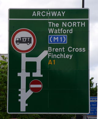
Archway is an area of north London, England, in the London Borough of Islington 3.8 miles (6 km) north of Charing Cross. It straddles the A1 and is named after a local landmark, the high, single-arched Archway Bridge which crossed the road in a cutting to the north. It has a modern commercial hub around Vantage Point and Archway tube station.

Liverpool Road is a street in Islington, North London. It covers a distance of 1+1⁄4 miles (2.0 km) between Islington High Street and Holloway Road, running roughly parallel to Upper Street through the area of Barnsbury. It contains several attractive terraces of Georgian houses and Victorian villas, many of which are listed buildings. There are a number of pubs, small businesses and restaurants along its route, as well as some secluded garden squares. The vast majority of the street is residential, with a bustling shopping and business area at the southern, Angel, end.

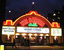
Upper Street is the main street of the Islington district of inner north London, and carries the A1 road. It begins at the junction of the A1 and Liverpool Road, continuing on from Islington High Street which runs from the crossroads at Pentonville Road/City Road and runs roughly northwards from outside the main entrance to Angel Underground station, then past the Business Design Centre, then splits at Islington Green, then past The Screen On The Green cinema, past Islington Town Hall, ending at Highbury & Islington tube station on Highbury corner, where the A1 carries on as Holloway Road.

Edmonton is a town in north London, England within the London Borough of Enfield, a local government district of Greater London. The northern part of the town is known as Lower Edmonton or Edmonton Green, and the southern part as Upper Edmonton. Situated 8.4 miles (13.5 km) north-northeast of Charing Cross, it borders Enfield to the north, Chingford to the east, and Tottenham to the south, with Palmers Green and Winchmore Hill to the west. The population of Edmonton was 82,472 as of 2011.

Essex Road is a main road in Islington, London. It is part of the A104 and connects Islington High Street with Balls Pond Road via Essex Road railway station.

The London Borough of Islington is short of large parks and open spaces, given its status in recent decades as a desirable place of residence. In fact, Islington has the lowest ratio of open space to built-up areas of any London borough. The largest continuous open space in the borough, at 11.75 hectares, is Highbury Fields.

The A104 is an A road which runs from Islington Green in London to Epping in Essex, England.
The A1 in London is the southern part of the A1 road. It starts at Aldersgate in the City of London, passing through the capital to Borehamwood on the northern fringe of Greater London, before continuing to Edinburgh. The road travels through the City and three London boroughs: Islington, Haringey and Barnet, which include the districts of Islington, Holloway, Highgate, Hendon and Mill Hill, and travels along Upper Street and Holloway Road, crossing the North Circular Road in Hendon, a district in the London Borough of Barnet.

Southgate Road is a street in London, England, that runs from Baring Street in the south to the junction with Mildmay Park and Ball's Pond Road in the north. The street forms a part of the B102 road, leading from Newington Green to The City. The west side of Southgate Road is in the London Borough of Islington; and the east side is in the London Borough of Hackney. Southgate Road lies north of the Regent's Canal, west of De Beauvoir Town and east of Essex Road.

Woodford is a town in East London, within the London Borough of Redbridge. It is located 9.5 miles (15.3 km) north-east of Charing Cross. Woodford historically formed an ancient parish in the county of Essex. It contained a string of agrarian villages and was part of Epping Forest. From about 1700 onwards, it became a place of residence for affluent people who had business in London; this wealth, together with its elevated position, has led to it being called the Geographical and social high point of East London. Woodford was suburban to London and after being combined with Wanstead in 1934 it was incorporated as a municipal borough in 1937. It has formed part of Greater London since 1965 and comprises the neighbourhoods of Woodford Green, Woodford Bridge, Woodford Wells and South Woodford. The area is served by two stations on the Central line of the London Underground: Woodford and South Woodford.

The New River Path is a long-distance footpath which follows the course of the 17th-century aqueduct, the New River, for 28 miles (45 km) from its source in Hertfordshire to its original end in Islington, London. The path is waymarked and all signs display the words "New River Path" on a green background.

Angel is an area on the northern fringes of Central London within the London Borough of Islington. It is 2 miles (3.2 km) north-northeast of Charing Cross on the Inner Ring Road at a busy transport intersection. The area is identified in the London Plan as one of 35 major centres in London. It is a significant commercial and retail centre, and a business improvement district. Angel straddles the ancient boundary of the parishes of Clerkenwell and Islington that later became the metropolitan boroughs of Finsbury and Islington. It is named from the former Angel Inn which stood on the corner of Islington High Street and Pentonville Road. Since 1965 the whole area has formed part of the London Borough of Islington in Greater London.