Bushy Park in the London Borough of Richmond upon Thames is the second largest of London's Royal Parks, at 445 hectares in area, after Richmond Park. The park, most of which is open to the public, is immediately north of Hampton Court Palace and Hampton Court Park and is a few minutes' walk from the west side of Kingston Bridge. It is surrounded by Teddington, Hampton, Hampton Hill and Hampton Wick and is mainly within the post towns of Hampton and Teddington, those of East Molesey and Kingston upon Thames taking the remainder.

The A316, known in parts as the Great Chertsey Road, is a major road in England, which runs from the A315 Chiswick High Road, Turnham Green, Chiswick to join head-on the M3 motorway at Sunbury-on-Thames. Its initial London section Chiswick Lane heads south — following this it is a mostly straight dual carriageway aligned WSW.

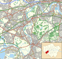
Hampton Hill is a district in the London Borough of Richmond upon Thames to the south of Twickenham, bounded by Fulwell and Twickenham Golf Course to the northwest; the road bridge over the railway line; a line southward just east of Wellington Road; Bushy Park to the southeast; and the artificial Longford River to the south and west. It is served by Fulwell railway station and Hampton railway station on the Shepperton to Waterloo line. It is part of what is collectively known as The Hamptons. Much of Hampton Hill High Street, and some neighbouring residential areas are designated as a conservation area.

Garrick's Villa is a Grade I listed country house located on Hampton Court Road in Hampton in the London Borough of Richmond upon Thames. Its park and gardens are listed at Grade II by Historic England in the Register of Historic Parks and Gardens of special historic interest in England.
The Painters Arms is a Grade II listed pub in Luton, England.

The Flora, also known as The Flora Hotel, is a pub at 525 Harrow Road, Kensal Green, London W10. It backs onto the Grand Union Canal. It is a Taylor Walker pub.
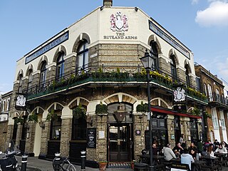
The Rutland Arms is a public house at 15 Lower Mall, Hammersmith, London, England. It was also called the Rutland Hotel.

The Tally Ho is a landmark public house in north Finchley, north London, under the management of the Stonegate Pub Company.

The Queen's is a pub and former hotel in Regent's Park Road, Primrose Hill, London.

The Railway Hotel is a former pub and hotel in Station Road, Edgware and a Grade II listed building with Historic England.

The Castle is a Grade II listed public house at 34-35 Cowcross Street, Smithfield, London.

On Thursday 9 October 1975, a bomb attack just outside Green Park Underground station in the City of Westminster, London, left one man dead and injured 20 others. The attack was carried out by volunteers from the Provisional IRA's Balcombe Street Gang. The attack occurred during a period of heightened activity by the IRA in England and in particular London and surrounding areas, since the Caterham Arms pub bombing two months earlier in August 1975.

The Lord Tredegar is a pub at 50 Lichfield Road, Bow, London E3.

The Mason's Arms is a pub on Battersea Park Road, Battersea, London SW8, situated opposite Battersea Park Railway Station.

The Denbigh Arms is a former pub at 3 Denbigh Place, Pimlico, London SW1.

The Knave of Clubs is a former pub at 25 Bethnal Green Road, Shoreditch, London E1. It closed in July 1994, and since 2001 has been Les Trois Garçons, a restaurant.
The Markham Arms is a former pub at 138 King's Road, London SW3. It closed as a pub in the early 1990s, and is now a branch of the Santander bank.

The Raven Inn is a former pub at 140 Westbridge Road, Battersea, London SW11. It was a pub until at least 2009, but is now Melanzana, an Italian restaurant.

The Commercial is a public house at 210-212 Railton Road, Herne Hill, London. It is cited in 'The CAMRA Regional Inventory for London' as being one of only 133 pubs in Greater London with a pub interior of special historic interest, most notably for its, "Original counters, bar-back, fireplaces and much fielded wall panelling" dating from the 1930s. In July 2016, Lambeth Council designated The Commercial as a locally-listed heritage asset of architectural or historic interest, being described as a, "Two-storey Neo Georgian style inter-war pub with a three-part convex façade which follows the curve of the building line".

Norfolk Buildings is a terrace of grade II listed houses at 73-91 Bristol Road, Gloucester, on the east side between Theresa Street and Alma Place.