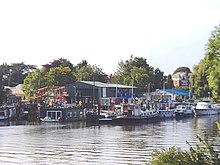
Eel Pie Island is an 8.935-acre (3.6 ha) island in the River Thames at Twickenham in the London Borough of Richmond upon Thames. It is on the maintained minimum head of water above the only lock on the Tideway and is accessible by boat or from the left bank by footbridge. The island had a club that was a major venue for jazz and blues in the 1960s.
This article lists the islands in the River Thames, or at the mouth of a tributary, in England. It excludes human-made islands built as part of the building of forty-five two-gate locks which each accompany a weir, and islets subordinate to and forming part of the overall shape of another. The suffix -ey is common across England and Scotland and cognate with ait and meaning island, a term – as ait or eyot – unusually well-preserved on the Thames. A small minority of list entries are referred to as Island, Ait or Eyot and are vestiges, separated by a depression in the land or high-water-level gully.

Pipers Island, or Piper's Island, is the third-smallest map-named island in the River Thames, in England. It is on the Reading, Berkshire reach. It is toward the edge of the central urban area of the town of Reading and connected by a gangway to Caversham Bridge, a road and pedestrian bridge that links that town to its left bank suburb of Caversham.
Trowlock Island is a residential island in the River Thames 450 metres (490 yd) upstream of Teddington Lock on the non-tidal Kingston reach less than 10 metres from the northern bank, in the London Borough of Richmond upon Thames, England.

The River Evenlode is a tributary of the Thames in Oxfordshire. It rises near Moreton-in-Marsh, Gloucestershire, in the Cotswold Hills and flows south-east to the Thames, its valley providing the route of the southern part of the Cotswold Line. The river flows for 45 miles (72 km) from source to the River Thames.
Lower Horse is a 31.1-acre (12.6 ha) uninhabited island off the English coast, lying in the Thames Estuary between Canvey Island and Stanford-le-Hope, close to grid reference TQ760828.

Chiswick Eyot is a 3.266-acre (1.3 ha) narrow, uninhabited ait of the Thames. It is a tree- and reed-covered rise on the Tideway by Chiswick, in London, England and is overlooked by Chiswick Mall and by some of the Barnes riverside on the far bank.

Desborough Island is a 112-acre (0.45 km2) manmade island in the River Thames on the reach above Sunbury Lock in Surrey, England. It was formed in the 1930s by the digging of a channel – the Desborough Cut – by the Thames Conservancy as a meander cutoff of narrow width on the right bank. The island and cut are named after Lord Desborough, a chairman of the Thames Conservancy.

Glover's Island is in a tree-lined section of river, formerly known as Horse Reach on the tidal Thames, between Richmond Lock and Teddington Lock in the Borough of Richmond upon Thames, London, England.

St John's Bridge is a two-section road bridge across the channel of the upper Thames near Lechlade, England, then across the lock cut to the south, the highest lock on the Thames. It is a Grade II listed building.

Tagg's Island, in the London Borough of Richmond upon Thames and part of Hampton, is an ait (island) on the River Thames on the reach above Molesey Lock and just above Ash Island. The island is roughly 400 metres long by 90 metres wide at its widest point, covering 6 acres. Although close to the Surrey bank near East Molesey, Surrey, the island is connected to the further Middlesex bank by a single track road bridge, being the only island on the non-tidal Thames accessible by car.

Hammerton's Ferry is a pedestrian and cycle ferry service across the River Thames in the London Borough of Richmond upon Thames, London, England. The ferry links the river's northern bank near Marble Hill House in Twickenham with its southern bank near Ham House in Ham. It is one of only four remaining ferry routes in London not to be replaced by a bridge or tunnel.

Hollyhock Island is an inhabited island in the River Thames in England on the reach between Bell Weir Lock and Penton Hook Lock.

Deadwater Ait is an island in the River Thames in England on the reach above Romney Lock, near Windsor, Berkshire.

Andersey Island is a 273-acre (110.5 ha) area of flood-meadow and former flood-meadow south-east of Abingdon Bridge, Abingdon, Oxfordshire on the reach above Culham Lock in which parish it lies however maintaining close links with Abingdon by virtue of its current amenities. It is the second-largest island of the non-tidal course of the River Thames in England upstream of the Tideway — if disqualifying the villages of Dorney and Eton, Berkshire enclosed by the engineered Jubilee River. Andersey means Andrew's island after its chapel to St Andrew, demolished, built about 1050 CE.

Brentford Ait is a long 4.572-acre (1.9 ha) uninhabited ait in the River Thames, without buildings, on the Tideway near Brentford in London, England.

Lot's Ait is a 1.724-acre (0.7 ha) ait in the Thames. It is on the Tideway near Brentford, in the London Borough of Hounslow, England.

Isleworth Ait, also known as Isleworth Eyot, is a between 3.5-hectare (8.6-acre) and 9.370-acre (3.792 ha) teardrop-shaped island in the River Thames in England. The long ait is on the Tideway facing Old Isleworth and the towpath alongside the Royal Mid-Surrey Golf Club. These places are in the London Boroughs of Hounslow and Richmond upon Thames. The island faces Heron's Place and a number of commercial buildings.

The River Wey is a main tributary of the River Thames in south east England. Its two branches, one of which rises near Alton in Hampshire and the other in West Sussex to the south of Haslemere, join at Tilford in Surrey. Once combined the flow is eastwards then northwards via Godalming and Guildford to meet the Thames at Weybridge. Downstream the river forms the backdrop to Newark Priory and Brooklands. The Wey and Godalming Navigations were built in the 17th and 18th centuries, to create a navigable route from Godalming to the Thames.