Barnes is a district in south London, England, part of the London Borough of Richmond upon Thames. It takes up the extreme north-east of the borough, and as such is the closest part of the borough to central London. It is centred 5.8 miles (9.3 km) west south-west of Charing Cross in a bend of the River Thames.

Mortlake is a suburban district of the London Borough of Richmond upon Thames on the south bank of the River Thames between Kew and Barnes. Historically it was part of Surrey and until 1965 was in the Municipal Borough of Barnes. For many centuries it had village status and extended far to the south, to include East Sheen and part of what is now Richmond Park. Its Stuart and Georgian history was economically one of malting, brewing, farming, watermen and the Mortlake Tapestry Works (1617–1704), Britain's most important producer. A London landmark, the former Mortlake Brewery or Stag Brewery, is on the edge of Mortlake.

East Sheen, also known as Sheen, is a suburb in south-west London in the London Borough of Richmond upon Thames.

Barnes railway station is a Grade II listed station in the London Borough of Richmond upon Thames, in southwest London, and is in Travelcard Zone 3. It is 7 miles 7 chains (11.4 km) down the line from London Waterloo. The station and all trains serving it are operated by South Western Railway.

Richmond Green is a recreation area near the centre of Richmond, a town of about 20,000 inhabitants situated in south-west London. Owned by the Crown Estate, it is leased to the London Borough of Richmond upon Thames. The Green, which has been described as "one of the most beautiful urban greens surviving anywhere in England", is roughly square in shape and its open grassland, framed with broadleaf trees, extends to roughly twelve acres. On the north-east side there is also a smaller open space called Little Green. Richmond Green and Little Green are overlooked by a mixture of period townhouses, historic buildings and municipal and commercial establishments including the Richmond Lending Library and Richmond Theatre.

Hampton Hill is a district in the London Borough of Richmond upon Thames to the south of Twickenham. It is bounded by Fulwell and Twickenham Golf Courses to the northwest; a railway line road bridge at the junction of Wellington Road and Clonmel Road; a line southward just east of Wellington Road; Bushy Park to the southeast; and the artificial Longford River to the south and west. Hampton Hill is served by Fulwell railway station and Hampton railway station on the Shepperton to Waterloo line. It is part of what is collectively known as The Hamptons. Much of Hampton Hill High Street, and some neighbouring residential areas are designated as a conservation area.

St Mary the Virgin, Mortlake, is a parish church in Mortlake, in the London Borough of Richmond upon Thames. It is part of the Church of England and the Anglican Communion. The rector is The Revd Canon Dr Ann Nickson.

St Mary Magdalen Roman Catholic Church, Mortlake, is a Roman Catholic church in North Worple Way, Mortlake, in the London Borough of Richmond upon Thames. The church is dedicated to Jesus' companion Mary Magdalene. It is located just south of Mortlake High Street and the Anglican St Mary the Virgin Church. St Mary Magdalen's Catholic Primary School is just north of the churchyard.

123 Mortlake High Street, also known as The Limes or Limes House and previously referred to as Mortlake Terrace, is a Grade II* listed 18th-century property on Mortlake High Street in Mortlake in the London Borough of Richmond upon Thames. The building is now used as commercial office space. It was originally a private house and in the 20th century it functioned as the local town hall. It is featured in two paintings by J. M. W. Turner.

St Michael and All Angels Church is a Grade II listed Church of England church in Barnes in the London Borough of Richmond upon Thames. It is located at 39 Elm Bank Gardens, London SW13 0NX.

All Saints Church, East Sheen, is a church in the London Borough of Richmond upon Thames, located at the junction of East Sheen Avenue and Park Avenue in East Sheen. All Saints Church is a member of the Anglican Communion and the Church of England and the style of worship is Modern Catholic. There are three regular Sunday services at 8:00am, 10:00am and at midday.
Christ Church, East Sheen, is a Church of England church in East Sheen in the London Borough of Richmond upon Thames.

The Mausoleum of Sir Richard and Lady Burton is a Grade II* listed tent-shaped mausoleum of Carrara marble and Forest of Dean stone in the churchyard of St Mary Magdalen Roman Catholic Church Mortlake in the London Borough of Richmond upon Thames. It contains the tombs of the Victorian explorer Sir Richard Burton (1821–90), who took part in the search for the source of the River Nile and translated The Arabian Nights, and his wife Isabel, Lady Burton (1831–96), who designed it. The coffins of Sir Richard and Lady Burton can be seen through a glass panel at the rear of the tent, which can be accessed via a short fixed ladder. The inscription includes a commemorative sonnet by Justin Huntly McCarthy (1859–1936), who lived in Putney.

St Leonard's Court is a four-storey block of flats on Palmers Road, off St Leonard's Road in East Sheen, London SW14 in the London Borough of Richmond upon Thames, 0.2 miles from Mortlake railway station. It was constructed between 1934 and 1938 and is remarkable for its surviving underground air raid shelter, built in anticipation of the Second World War and now Grade II listed.

18 Station Road, also known as Milbourne House, is a Grade II* listed house at Station Road, Barnes, London SW13, in the London Borough of Richmond upon Thames. It has an early 18th-century facade, and earlier features internally.

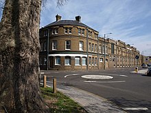
The Terrace is a street in Barnes in the London Borough of Richmond upon Thames. It forms part of the A3003, and runs west from its junction with Barnes High Street and Lonsdale Road to the east, where it becomes Mortlake High Street. Only one side of the street has houses; they all overlook the River Thames.

Barnes High Street is a road running through the centre of Barnes in England. It is located in the London Borough of Richmond upon Thames and is the high street of the suburb of Barnes featuring a number of commercial properties including shops and pubs. It is located a short distance from Barnes Bridge railway station.

Church Road, Barnes is a street in Barnes in the London Borough of Richmond upon Thames. It runs from the junction between Rocks Lane and Castlenau by the Red Lion pub, westwards to the end of Barnes High Street. It takes its name from the St Mary's Church, a Church of England building dating back to the twelfth century. Also located on the street are the Sun Inn and the early eighteenth century The Homestead, both Grade II listed. Barnes Green runs on the south side of the street. The Olympic Studios were located in the street, notable for the records that Jimi Hendrix made there.