
Barnes is a district in south London, England, part of the London Borough of Richmond upon Thames. It takes up the extreme north-east of the borough, and as such is the closest part of the borough to central London. It is centred 5.8 miles (9.3 km) west south-west of Charing Cross in a bend of the River Thames.

The A316, known in parts as the Great Chertsey Road, is a major road in England, which runs from the A315 Chiswick High Road, Turnham Green, Chiswick to join head-on the M3 motorway at Sunbury-on-Thames. Its initial London section Chiswick Lane heads south – following this it is a mostly straight dual carriageway aligned WSW.

Hampton Hill is a district in the London Borough of Richmond upon Thames to the south of Twickenham. It is bounded by Fulwell and Twickenham Golf Courses to the northwest; a railway line road bridge at the junction of Wellington Road and Clonmel Road; a line southward just east of Wellington Road; Bushy Park to the southeast; and the artificial Longford River to the south and west. Hampton Hill is served by Fulwell railway station and Hampton railway station on the Shepperton to Waterloo line. It is part of what is collectively known as The Hamptons. Much of Hampton Hill High Street, and some neighbouring residential areas are designated as a conservation area.

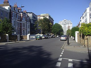
Castelnau is a road in Barnes, in the London Borough of Richmond upon Thames, south west London, approximately 5.1 miles (8.2 km) west from Charing Cross on the south side of the River Thames. About 1.1 miles (1.8 km) long, it is the main road south from Hammersmith Bridge and forms part of the A306 road. It was originally named Upper Bridge Road. The name Castelnau is also used informally for Castelnau Estate and the area surrounding the road. It joins Church Road at is southern end, which then runs westwards beside Barnes Green until it meets Barnes High Street.
Christ's School is a Church of England secondary school, located in Richmond, London. It has the distinction of being the only Church of England secondary school in Richmond upon Thames. Around 670 pupils, between the ages of 11 and 19, attend the school.

There are 72 Grade II* listed buildings in the city of Brighton and Hove, England. The city, on the English Channel coast approximately 52 miles (84 km) south of London, was formed as a unitary authority in 1997 by the merger of the neighbouring towns of Brighton and Hove. Queen Elizabeth II granted city status in 2000.

Belsize Park Gardens is a street in the Belsize Park area of Hampstead in London. Located in the London Borough of Camden, it is residential street featuring white stucco Victorian era buildings. It runs roughly southeastwards from Belsize Avenue in Belsize Village before terminating at a junction with Eton Avenue, England's Lane and Primrose Hill Road. The Grade II listed pub The Washington, dating from around 1865, is located at its eastern end.
Abercorn Place is a street in St John's Wood in London. Located in the City of Westminster, it runs west to east from the Edgware Road at Maida Vale until it joins Abbey Road not far from the Abbey Road Studios to the south. It is crossed by Hamilton Terrace. The street is named after the Duke of Abercorn, an Anglo-Irish aristocrat. It was part of an estate originally owned by Harrow School of which Abercorn was a governor with other nearby streets similarly named. The street contains a mixture of housing from the 1820s onwards. Several buildings in the street are listed today. The Anglican St Mark's Church was built in 1847 at the intersection with Hamilton Terrace. It was designed in the Gothic style by the architect Thomas Cundy.

Carlton Vale is a street that runs through Kilburn and Maida Vale in London. Some of its route forms the boundary between the City of Westminster to the south and the London Borough of Brent to the north. To the west the street continues as Kilburn Lane through Queen's Park, while to the east it becomes Carlton Hill running into St. John's Wood. Carlton Vale crosses or meets several roads including Kilburn Park Road, Cambridge Road and Randolph Avenue.

Gloucester Avenue is a street in the Primrose Hill area of London, England. Located in the London Borough of Camden, it is a residential road featuring many nineteenth century properties including several pubs as well as the neo-Georgian Cecil Sharp House. For much of its route it runs adjacent to the West Coast Main Line out of Euston Station.

Mortlake High Street is a street running through Mortlake in west London in England, United Kingdom. Located in the London Borough of Richmond, it is the historic high street of Mortlake dating back several centuries. It runs from east to west, beginning at The Terrace, Barnes and running parallel to the southern bank of the River Thames and finishing at Mortlake Green close to Mortlake railway station and the site of the former Mortlake Brewery. It forms part of the A3003 road.

Norland Square is a garden square in the Notting Hill area of London. Located in the Royal Borough of Kensington and Chelsea, runs northward from Holland Park Avenue to Queensdale Road. The mews street Norland Place runs eastwards of the Square.

Connaught Street is a street in Central London. Located in the City of Westminster, it is part of the Tyburnia area of Paddington north of Hyde Park. It runs west to east from Hyde Park Square to the Edgware Road. It continues eastwards becoming Upper Berkeley Street in Marylebone. The street contains a mixture of commercial and residential properties, forming part of Connaught Village. Connaught Square and Albion Street are located on its southern side. The Duke of Kendal public house sits at the junction between Connaught Street and Kendal Street.

Eton Avenue is a street in the Belsize Park area of Hampstead in North London. Located in the London Borough of Camden, it runs eastward from Swiss Cottage tube station to a junction with England's Lane, Primrose Hill Road and Belsize Park Gardens by The Washington pub. Fellows Road and Adelaide Road run parallel to the south of Eton Avenue.

Well Road is a street in Hampstead, England in the London Borough of Camden. It runs westwards from Hampstead Heath to New End Square. Well Walk runs parallel to its south and the two are linked by Wells Passage. When the Hampstead Wells were in existence, a large pump room and assembly room were located on Well Walk, with the water supplied from the headspring on Well Road.

New End Square is a square in Hampstead, in the London Borough of Camden. It dates back to the early eighteenth century when it was located close to the Hampstead Wells spa on the adjacent Well Walk. Despite its name it is not rectangular. At its northern end is the Old White Bear pub dating back to 1704, on the corner with Well Road. Its southern end is at the junction between Flask Walk and Well Walk. New End street curls off from one corner of the square, eventually heading west to Heath Street.

Pond Street is located in Hampstead in the London Borough of Camden. It runs eastwards from Rosslyn Hill to South End Green, located in the old "South End" of the settlement. The street takes its name from an ancient pond at South End Green, a source of the River Fleet, and has been known by this name since at least 1678. The pond survived into the Victorian era.
Hampstead Way is a street at the northern edge of Hampstead. It is located primarily in the London Borough of Barnet although its southern end forms a border with the London Borough of Camden in which the rest of Hampstead is located. In the south it is part of the old hamlet of North End, which marked the northern boundary of Hampstead, but then curves northwards and follows the edge of Hampstead Heath into Golders Green and Hampstead Garden Suburb. The southern end leads off North End Way.

Barnes High Street is a road running through the centre of Barnes in England. It is located in the London Borough of Richmond upon Thames and is the high street of the suburb of Barnes featuring a number of commercial properties including shops and pubs. It is located a short distance from Barnes Bridge railway station.

Loudoun Road is a street in the St John's Wood area of London. Most of its route is in the City of Westminster, but it crosses into the London Borough of Camden at its northern end in South Hampstead. It runs roughly parallel to Finchley Road to its east while Abbey Road, London is to the west. It runs north from Grove End Road, not far from St John's Wood tube station, and crosses or is joined by a number of streets including Marlborough Place, Carlton Hill and Boundary Road. It finishes at a roundabout junction with several streets including Belsize Road and Fairhazel Gardens. South Hampstead railway station is at the northern end of the street.


