Barnes High Street

Last updated
Northern end of the street where it meets The Terrace by the River Thames. Roundabout at the end of Barnes High St - geograph.org.uk - 2112811.jpg
Northern end of the street where it meets The Terrace by the River Thames.
Entrance to The Bull's Head. Bull's Head, Barnes, October 2014 04.jpg
Entrance to The Bull's Head.
The Grade II listed Rose House at 70 Barnes High Street, located close to the southern end of the street by Barnes Green. 70 Barnes High Street, March 2014 02.jpg
The Grade II listed Rose House at 70 Barnes High Street, located close to the southern end of the street by Barnes Green.

Barnes High Street is a road running through the centre of Barnes in England. [1] It is located in the London Borough of Richmond upon Thames and is the high street of the suburb of Barnes featuring a number of commercial properties including shops and pubs. It is located a short distance from Barnes Bridge railway station.

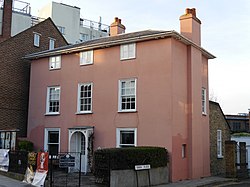
It runs from The Terrace in the north by the River Thames to Barnes Green where it forks with one route Station Road heading on south towards Barnes railway station and on the other Church Road curving eastwards towards St Mary's Church and onwards in the general direction of Putney. Notable buildings include the Grade II listed Rose House, dating back to the seventeenth century [2] and The Bull's Head pub, which gained fame as a music venue in the twentieth century. Another pub, the Coach and Horses, is located nearby. [3] Old Essex House is located just to the south of the junction with Station Road. The street is referred to in the 1907 novel The City of Pleasure by Arnold Bennett.

Related Research Articles

<span class="mw-page-title-main">Kingston upon Thames</span> Town in South West London

Kingston upon Thames is a town in the Royal Borough of Kingston upon Thames, southwest London, England. It is situated on the River Thames and 10 miles (16 km) southwest of Charing Cross. It is notable as the ancient market town in which Saxon kings were crowned and today is the administrative centre of the Royal Borough of Kingston upon Thames.

<span class="mw-page-title-main">Barnes, London</span> Area of south-west London, England

Barnes is a district in south London, England, part of the London Borough of Richmond upon Thames. It takes up the extreme north-east of the borough, and as such is the closest part of the borough to central London. It is centred 5.8 miles (9.3 km) west south-west of Charing Cross in a bend of the River Thames.

<span class="mw-page-title-main">Royal Borough of Kingston upon Thames</span> Royal borough in London, England

The Royal Borough of Kingston upon Thames is a borough in southwest London. The main town is Kingston upon Thames and it includes Chessington, Malden Rushett, New Malden, Surbiton and Tolworth. It is the oldest of the four royal boroughs in England. The others are the London boroughs of Greenwich and Kensington and Chelsea and Windsor and Maidenhead, the site of Windsor Castle. The local authority is Kingston upon Thames London Borough Council.

<span class="mw-page-title-main">Mortlake</span> Human settlement in England

Mortlake is a suburban district of the London Borough of Richmond upon Thames on the south bank of the River Thames between Kew and Barnes. Historically it was part of Surrey and until 1965 was in the Municipal Borough of Barnes. For many centuries it had village status and extended far to the south, to include East Sheen and part of what is now Richmond Park. Its Stuart and Georgian history was economically one of malting, brewing, farming, watermen and the Mortlake Tapestry Works (1617–1704), Britain's most important producer. A London landmark, the former Mortlake Brewery or Stag Brewery, is on the edge of Mortlake.

<span class="mw-page-title-main">London Borough of Richmond upon Thames</span> London borough in United Kingdom

The London Borough of Richmond upon Thames in southwest London, England, forms part of Outer London and is the only London borough on both sides of the River Thames. It was created in 1965 when three smaller council areas amalgamated under the London Government Act 1963. It is governed by Richmond upon Thames London Borough Council and is divided into nineteen wards. The population is 198,019 and the major settlements are Barnes, East Sheen, Mortlake, Kew, Richmond, Twickenham, Teddington and Hampton.

Richmond is a town in south-west London, 8.2 miles (13.2 km) west-southwest of Charing Cross. It stands on the River Thames, and features many parks and open spaces, including Richmond Park, and many protected conservation areas, which include much of Richmond Hill. A specific Act of Parliament protects the scenic view of the River Thames from Richmond.

<span class="mw-page-title-main">East Sheen</span> Suburb of London in the London Borough of Richmond upon Thames

East Sheen, also known as Sheen, is a suburb in south-west London in the London Borough of Richmond upon Thames.

<span class="mw-page-title-main">Whitton, London</span> Human settlement in England

Whitton is an area of the London Borough of Richmond upon Thames, England. Historically, it was the north-western part of Twickenham manor, bounded by the River Crane and the Duke of Northumberland's River.

<span class="mw-page-title-main">Richmond Green</span> Park in Richmond, London, England

Richmond Green is a recreation area near the centre of Richmond, a town of about 20,000 inhabitants situated in south-west London. Owned by the Crown Estate, it is leased to the London Borough of Richmond upon Thames. The Green, which has been described as "one of the most beautiful urban greens surviving anywhere in England", is roughly square in shape and its open grassland, framed with broadleaf trees, extends to roughly twelve acres. On the north-east side there is also a smaller open space called Little Green. Richmond Green and Little Green are overlooked by a mixture of period townhouses, historic buildings and municipal and commercial establishments including the Richmond Lending Library and Richmond Theatre.

<span class="mw-page-title-main">Kingston Railway Bridge</span> Bridge in Kingston upon Thames

Kingston Railway Bridge in Kingston upon Thames, London, crosses the River Thames on the reach above Teddington Lock. It carries the Kingston Loop Line train service from London Waterloo station, where the majority of services begin and end and which line includes a maintenance depot. The loop diverges from main lines at New Malden and Richmond. East and west of the bridge along the line are Kingston and Hampton Wick stations. The loop returns to the south bank of its terminus via Richmond Railway Bridge. The loop feeds a branch line, a further incentive for the 1863 construction of the bridge, Shepperton Branch Line.

<span class="mw-page-title-main">Barnes Railway Bridge</span> Bridge in London, England

Barnes Railway Bridge is a Grade II listed railway bridge in the London Borough of Richmond upon Thames and the London Borough of Hounslow. It crosses the River Thames in London in a northwest to southeast direction at Barnes. It carries the South Western Railway's Hounslow Loop Line, and lies between Barnes Bridge and Chiswick stations. It can also be crossed on foot, and is one of only three bridges in London to combine pedestrian and rail use; the others being Hungerford Bridge and Golden Jubilee Bridges and Fulham Railway Bridge.

<span class="mw-page-title-main">A316 road</span> Road in England

The A316, known in parts as the Great Chertsey Road, is a major road in England, which runs from the A315 Chiswick High Road, Turnham Green, Chiswick to join head-on the M3 motorway at Sunbury-on-Thames. Its initial London section Chiswick Lane heads south – following this it is a mostly straight dual carriageway aligned WSW.

<span class="mw-page-title-main">Hampton Hill</span> Suburb of south west London

Hampton Hill is a district in the London Borough of Richmond upon Thames to the south of Twickenham. It is bounded by Fulwell and Twickenham Golf Courses to the northwest; a railway line road bridge at the junction of Wellington Road and Clonmel Road; a line southward just east of Wellington Road; Bushy Park to the southeast; and the artificial Longford River to the south and west. Hampton Hill is served by Fulwell railway station and Hampton railway station on the Shepperton to Waterloo line. It is part of what is collectively known as The Hamptons. Much of Hampton Hill High Street, and some neighbouring residential areas are designated as a conservation area.

<span class="mw-page-title-main">Castelnau, London</span> Human settlement in England

Castelnau is a road in Barnes, in the London Borough of Richmond upon Thames, south west London, approximately 5.1 miles (8.2 km) west from Charing Cross on the south side of the River Thames. About 1.1 miles (1.8 km) long, it is the main road south from Hammersmith Bridge and forms part of the A306 road. It was originally named Upper Bridge Road. The name Castelnau is also used informally for Castelnau Estate and the area surrounding the road. It joins Church Road at is southern end, which then runs westwards beside Barnes Green until it meets Barnes High Street.

<span class="mw-page-title-main">Barnes Common</span> Organization and common land in London

Barnes Common is a local nature reserve on common land in the south east of Barnes, London, England, adjoining Putney Lower Common to the east and bounded to the south by the Upper Richmond Road. Along with Barnes Green, it is one of the largest zones of common land in London with 49.55 hectares of protected commons. It is also a Local Nature Reserve. Facilities include a full-size football pitch and a nature trail.

<span class="mw-page-title-main">St Mary the Virgin, Mortlake</span> Church in London

St Mary the Virgin, Mortlake, is a parish church in Mortlake, in the London Borough of Richmond upon Thames. It is part of the Church of England and the Anglican Communion. The rector is The Revd Canon Dr Ann Nickson.

<span class="mw-page-title-main">St Michael and All Angels Church, Barnes</span> Church in Barnes in the London Borough of Richmond upon Thames, United Kingdom

St Michael and All Angels Church is a Grade II listed Church of England church in Barnes in the London Borough of Richmond upon Thames. It is located at 39 Elm Bank Gardens, London SW13 0NX.

<span class="mw-page-title-main">The Terrace, Barnes</span> Street in Barnes, London, England

The Terrace is a street in Barnes in the London Borough of Richmond upon Thames. It forms part of the A3003, and runs west from its junction with Barnes High Street and Lonsdale Road to the east, where it becomes Mortlake High Street. Only one side of the street has houses; they all overlook the River Thames.

<span class="mw-page-title-main">Mortlake High Street</span> Street in London, England

Mortlake High Street is a street running through Mortlake in west London in England, United Kingdom. Located in the London Borough of Richmond, it is the historic high street of Mortlake dating back several centuries. It runs from east to west, beginning at The Terrace, Barnes and running parallel to the southern bank of the River Thames and finishing at Mortlake Green close to Mortlake railway station and the site of the former Mortlake Brewery. It forms part of the A3003 road.

<span class="mw-page-title-main">Church Road, Barnes</span> Street in London, England

Church Road, Barnes is a street in Barnes in the London Borough of Richmond upon Thames. It runs from the junction between Rocks Lane and Castlenau by the Red Lion pub, westwards to the end of Barnes High Street. It takes its name from the St Mary's Church, a Church of England building dating back to the twelfth century. Also located on the street are the Sun Inn and the early eighteenth century The Homestead, both Grade II listed. Barnes Green runs on the south side of the street. The Olympic Studios were located in the street, notable for the records that Jimi Hendrix made there.

References

  1. Pevsner p.73
  2. https://historicengland.org.uk/listing/the-list/list-entry/1193550
  3. Time Out Guide Pubs & Bars. Time Out Guides, 2003. p.232

Bibliography

Commons-logo.svg Media related to Barnes High Street at Wikimedia Commons

51°28′31″N0°14′56″W / 51.4754°N 0.2489°W / 51.4754; -0.2489